|
In Designing a Liveable City - Part 1, students designed a town In Designing a Liveable City - Part 2, students completed a self-assessment of their town. In Designing a Liveable City - Part 3, students gave and received peer feedback on their towns and responded to the feedback. In Designing a Liveable City - Part 4, students developed their towns working in a larger group, by applying the 5Cs of community building. When students arrive in the class all group tasks have been attached together to make one large city. Some additional land/building spaces has also been added (additional pieces of paper). Students are still responsible for their own area and ensuring the liveability of their residents, but they will now have a say in how the whole city develops. Students will be provided with a number of development proposals that will go before a combined council meeting involving the whole class. They are provided with 5 minutes in their original group to determine which of the developments they might like in/near their original development area. They will also need to assess how each of the developments will impact on liveability of residents.
Developments:
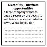
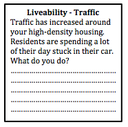
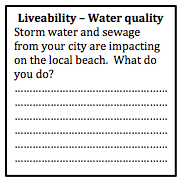
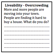
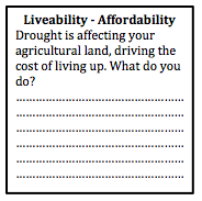
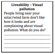
Highway A new highway has been built along the edge of the city. Parts of the city which are connected to the highway will have greater access to other parts of the city, other cities and regional areas. However, people around the area of the off-ramp will also be negatively affected by construction and possibly some demolition to make way for new roads. You will need to decide where the off-ramps for the highway will be located. You are allowed to have three off-ramps in total. (Off ramps - minimum 8 cm long) Resort Complex A large multination corporation wants to build a resort complex and marina. It will include several large hotels, a golf course, and specially designed harbour with moorings for yachts and pleasure craft (boats). It needs to be located on the coastline to take advantage of beach locations and provide an appropriate location for the marina. It also needs to be accessible by road. Choose an appropriate location. (Marina - 8cx8cm, resort complex 10cmx10cm). Recreational Complex The Federal government is going to provide substantial funding for a recreation and lifestyle complex and regional park. It will include a number of tennis courts, basketball/netball courts, soccer fields, football fields, as well as some open parkland with bike paths and foot paths. The complex will contribute positively to the quality of life of your residents. Choose an appropriate location. (Recreation complex 12 cmx12cm). National Park Lobbyists have proposed the creation of a national park. The park will protect environmental quality, provide opportunities for recreation (e.g. bushwalking, mountain climbing or snorkelling), and provide opportunities for tourism activities. Choose an appropriate location for the national park (12 cmx12cm). Technology hub A giant technology firm wants to set up a Tech Hub which will include a number of start-up businesses (new, small businesses) as well as several large technology businesses all in the one space. This will provide opportunities for employment in the city. (Tech Hub – 10cmx10cm) Assessing impact As individuals, students need to consider how each of these proposals will impact on liveability for residents, by determining the pros and cons of each proposal. Proposing a site In their original groups, students need to choose the proposal they are most interested in, propose an appropriate site and explain the impact on liveability. Council meeting As a whole class, the students will need to make decisions by consensus, debating and assessing the developments for Liveability. They will need to determine which developments will go ahead, and the best locations for each development proposal.
0 Comments
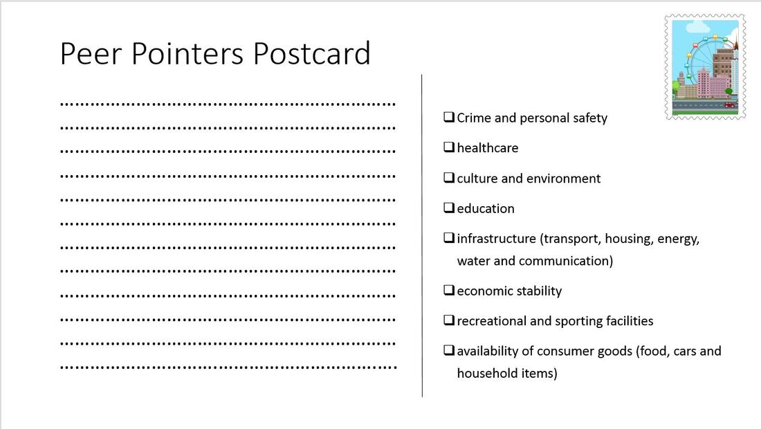
In Designing a Liveable City - Part 1, students designed a town In Designing a Liveable City - Part 2, students completed a self-assessment of their town. In Designing a Liveable City - Part 3, students gave and received peer feedback on their towns and responded to the feedback. When students arrive for this lesson, their towns have changed. The work of two groups has been joined together, so that two towns are now stuck together with some blank space in between. After working together with the one group for a while, at first students may be a little reluctant to work with others in a bigger group, but before long you will find that they will get on board knowing that they have more space to expand their town. Begin the lesson by revising content about Community and the characteristics that influence community identity. Discuss different suburbs or towns close to the school and how each of them have different identities and why. Discuss the culture of different places, and how the culture is expressed through public events and architecture. Revise the role of transport, technology, open spaces, meeting places and employment in building community. Read: The 5 "Cs" of community planning The students will be able to use the 5 "Cs" to guide the way they continue to develop their towns. Students move to their new, combined town and begin working with a larger group. They need to begin by explaining the different aspects of their initial town with the other half of the group and vice versa. Next they need to join the two towns together with roads and public transport and negotiate on how the land between the two towns will be used. Give them a set period of time (5-10 minutes depending on how much is left of the lesson) to work on each of the 5 'Cs'. At the end of the lesson they need to do a quick reassessment of the liveability of their new town based on the criteria provided in the previous lesson. 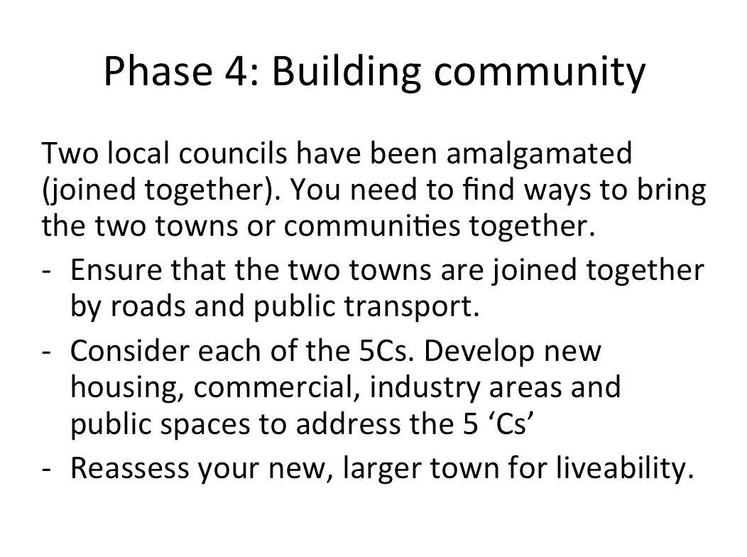 In Designing a Liveable City - Part 1, students designed a town. In Designing a Liveable City - Part 2, students completed a self-assessment of their town. Peer feedback provides an opportunity for students to assess liveability in a practical way, and also allows students to reflect on the feedback of others to make improvement in liveability. Hints on providing feedback. It is important to provide some guidance to students on how to provide effective feedback to their peers. If feedback is too harsh or personal it will not have the desired effect on progress. Provide the students with a brief criteria to base their judgements on, and go through the items listed to ensure the students know what all of the terms mean and the purpose of the task. In this case the criteria is a list of items that contribute to liveability. Students might just make simple suggestions such as "You need to build a high school" or "You need to build a hospital", but hopefully they will provide more detailed responses that indicate more knowledge of course content. In this lesson there were 6 groups of students, and each group rotated around to comment on the town plans of each other group. They were given "Peer Pointer Postcards" to write their comments on. They then returned to their own town map and had to reflect on the feedback given and consider changes to make to their plan. It is worth asking students to hand in their peer feedback to the teacher so you can check the comments that are made. This can then enable the teacher to ask the student to review any comments that are too personal or not detailed enough. Hints on receiving feedback Students who aren't used to peer feedback, may initially become defensive or upset about negative feedback. As the teacher it is important to prepare the students so they are ready and willing to accept ideas from others. A few tips for students:
 In Designing a Liveable City - Part 1, students designed a city. Once students have planned their city, they need to undertake a self assessment of their work. As a group they can sit and talk about the different aspects of their city and how they have addressed liveability. Provide them with a criteria to refer to. This might also be a good opportunity to provide students with a summary of the content that has been covered in class in relation to liveability, so that they can make connections between the activity they have been undertaking and course content.
The aim of this series of lessons is to allow students to apply their understanding of Liveability to a city design task. Students work in groups of 2-3 to design a small town, as the activity progresses they will reflect on what they have learnt in the Place and Liveability topic and apply it to their town. Phase 1: Design your town The first phase of this task involves designing the layout of the town. This will involve the initial road layout, agricultural land uses, some initial commercial land uses, power supply, and water storage. Provide some student choices so that you can provide a few variations in the first round of feedback. Provide students with a base page ( it may or may not have some geographical features on it such as mountains, coastline, rivers, etc). Also provide students with some blank, coloured pieces of paper, or you can copy the templates onto coloured paper - green (agricultural land), blue (water storage), pink (commercial), red (power supply), grey (roads). 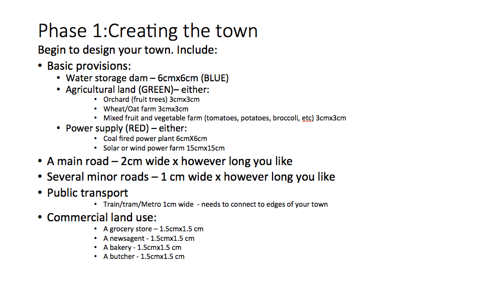
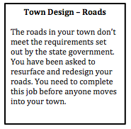
Design feedback This is an opportunity to provide some initial feedback to ensure the students get the basics right. Design the feedback so that it refers to the students as though they are members of the local council. For example, “The roads in your town don’t meet the requirements set out by the state government. You have been asked to resurface and redesign your roads. You need to complete this job before anyone moves into your town.”
Phase 2: Moving in... In the second phase of the task, students design the residential layout and density of the town. By placing a relatively small limit on the number of dwellings students have to focus on the layout of the town in the initial phases. 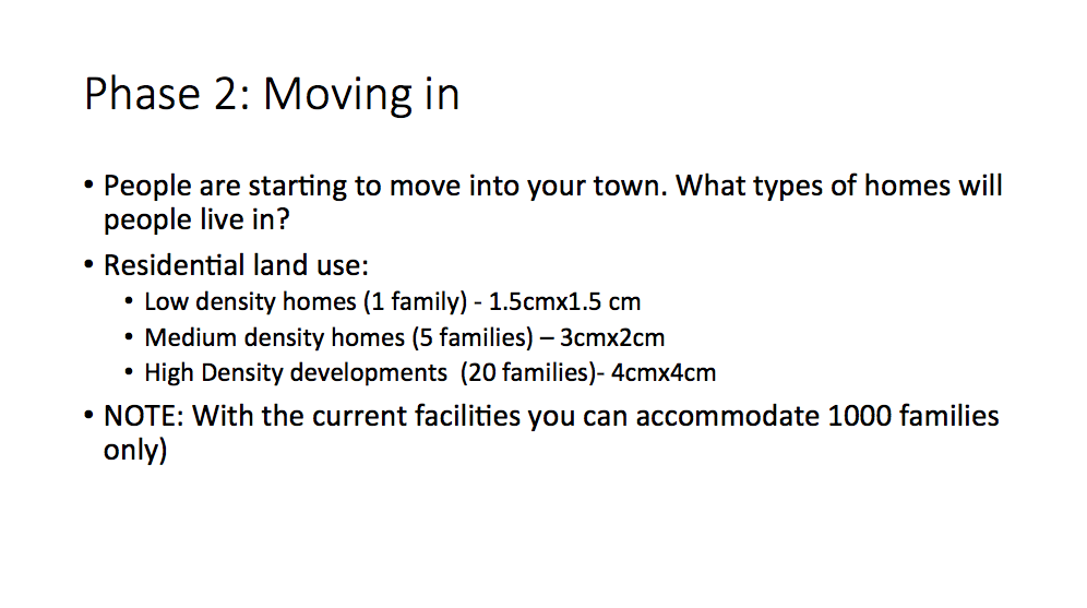
Town plan scenarios Provide students with some scenarios that will allow them to start to think about the liveability of their towns. By this stage some of the groups' conversations will have already addressed aspects of liveability, but they may not have actually considered in much depth. Students are required to write a brief description of how they addressed each scenario.
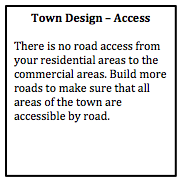
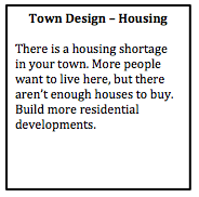
Phase 3: Enhancing liveability Students will need to respond to the scenarios above, and should have started to consider some of the additional needs of a community. As a class discuss the content related to liveability that you have already covered in class, and then provide students with time to make changes to their town plan. 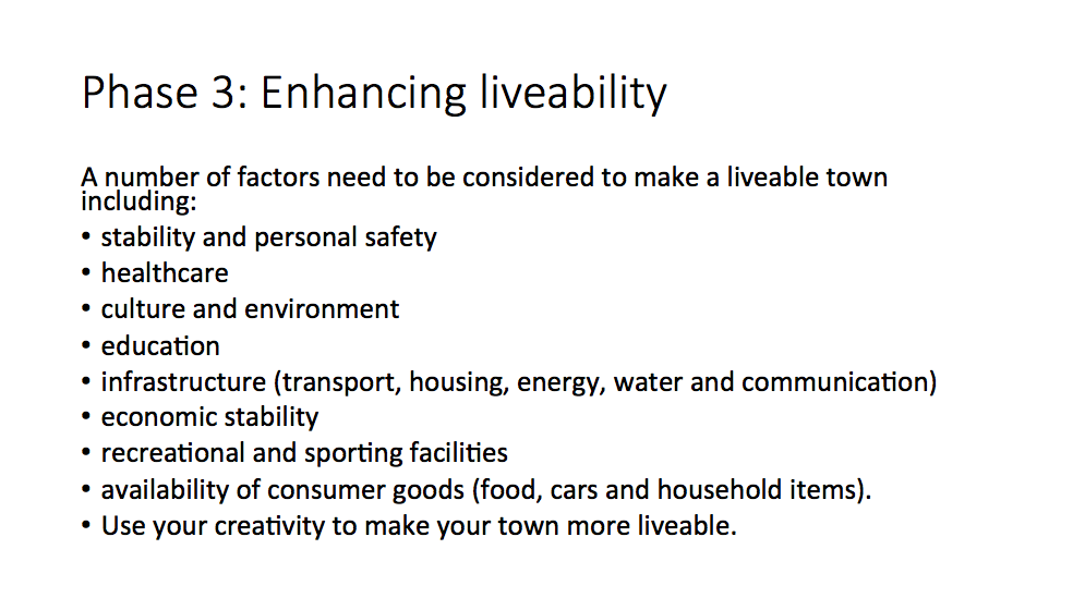 Phase 3: Liveability Students spend some time reviewing their towns and providing initiatives and strategies to make their town more liveable. They also need to address the scenarios provided by the teacher. Writing task Students need to write a description of how their town addresses different aspects of sustainability. Peer feedback Students rotate around to visit other groups' town. They provide feedback on the liveability of each town and make suggestion on how to improve liveability for each town. Next... refer to Designing a Liveable City - Part 2.
This is part of a unit of work for Changing Places - Australia's Urban Future. Lesson 1: Australia's Projected Population Growth Lesson 2: Implications for Future Growth and Sustainability Lesson 3: Sydenham to Bankstown Urban Renewal Precinct Lesson 4: WestConnex - Sydney, Sustainability and Transport Lesson 4: Sydney Sustainability and Transport (Teacher's Notes) Lesson 5: The GreenWay Lesson 5: Deindustrialisation Lesson 6: Create an infographic Lesson 7: Contributing to a Sustainable Urban Future Lesson 7: WestConnex - Protest Movements and Impacts Lesson 7: Conflict Over Dulwich Hill OR See the complete unit on the Changing Places website. Population forecasts for continued and accelerating growth or urban areas have a range of implications for sustainability. Sustainability is development that meets the needs of the present population without endangering the capacity of future generations to meet their needs. Indicators of sustainability in urban areas include air and water quality, biodiversity, integration of green building initiatives, health and well being measures, employment rates, transport infrastructure and access to employment. Implications of growth of urban areas include loss of agricultural land, habitat areas and open space, increased pressure on transport infrastructure resulting in heavy flows of commuter traffic and traffic congestion. Planning for the future growth of urban centres in Australia needs to address the provision of:
Priority Precincts and increased density An increase in density of urban areas creates more compact, “efficient” urban areas. This allows for services and infrastructure to be provided for a greater number of people and can allow residents to access public transport more easily and become less reliant on cars. The State Government’s Priority Precinct Program encourages population growth and increased density in specified areas. The Sydenham to Bankstown Urban Renewal Corridor includes the Inner West suburbs of St Peters, Sydenham, Tempe, Marrickville, Dulwich Hill and Hurlstone Park. For further reading click: http://www.urbangrowth.nsw.gov.au/assets/Living-Cities/CfS-Discussion-Paper-Making-Great-Places-Density-Done-Well.pdf Connectivity and Infrastructure Public infrastructure such as hospital, police centres, schools, trains, buses and roads is required for cities to function effectively. Upgrades of schools include Ashfield Boys, Ashbury Public, Croydon Public, and the construction of NSW School of Languages at Petersham. An ambulance super centre is being built at Haberfield. Transport infrastructure includes the construction of the Metroline and the M4 East extension, M5 extension and the M4-5 link.
This post was originally written in January 2017, and edited in March 2018. This is part of a unit of work for Changing Places - Australia's Urban Future. Lesson 1: Australia's Projected Population Growth Lesson 2: Implications for Future Growth and Sustainability Lesson 3: Sydenham to Bankstown Urban Renewal Precinct Lesson 4: WestConnex - Sydney, Sustainability and Transport Lesson 4: Sydney Sustainability and Transport (Teacher's Notes) Lesson 5: The GreenWay Lesson 5: Deindustrialisation Lesson 6: Create an infographic Lesson 7: Contributing to a Sustainable Urban Future Lesson 7: WestConnex - Protest Movements and Impacts Lesson 7: Conflict Over Dulwich Hill OR See the complete unit on the Changing Places website. Changing Places (Year 9) The Changing Places topic requires students to explain processes and influences that form and transform places and environments (GE5-2) and to assess management strategies for places and environments for their sustainability (GE5-5). The topic requires students to examine urbanisation, the impact of migration and strategies to address change in urban places and how they enhance sustainability. As a part of examining the causes and consequences of urbanisation, students will have investigated spatial distribution patterns of urbanisation (for example the influence of transport corridors), and the social, economic and environmental consequences of urbanisation (this could include traffic congestion, costs of tolls or costs of constructing new infrastructure, average times people spend commuting to work, the impact of car exhaust on air quality). In examining urban settlement patterns students will specifically address the impact of transportation networks in Australian and another country to explain differences in urban concentrations. While there is scope to deal with a range of issues and influences related to urbanisation and urban settlement, there is certainly an opportunity to develop a unit of work that develops students’ understanding in car dependence, traffic congestion, public transport, road networks, etc. to lead them to be able to examine this issue of the WestConnex development from a range of perspectives and with detailed background knowledge. In the last part of the Changing Places topic students investigate the management and planning of Australia’s urban future, including Australia’s population projections, implications for growth and sustainability, strategies to create sustainable urban places and ways for individuals and groups to become involved. WestConnex provides a great case study to examine this. Obviously you need to address the points at the national scale, but the WestConnex project impacts on such a large are of Sydney that you might find that many of your students are already engaged with (or at least aware of) the project in some way. Urban Places/ Urban Dynamics (Year 12) If you choose to do Sydney as a large city case study for Urban Places the WestConnex project could also tie into the - growth, development, future trends and ecological sustainability dot point.  This is part of a unit of work for Changing Places - Australia's Urban Future. Lesson 1: Australia's Projected Population Growth Lesson 2: Implications for Future Growth and Sustainability Lesson 3: Sydenham to Bankstown Urban Renewal Precinct Lesson 4: WestConnex - Sydney, Sustainability and Transport Lesson 4: Sydney Sustainability and Transport (Teacher's Notes) Lesson 5: The GreenWay Lesson 5: Deindustrialisation Lesson 6: Create an infographic Lesson 7: Contributing to a Sustainable Urban Future Lesson 7: WestConnex - Protest Movements and Impacts Lesson 7: Conflict Over Dulwich Hill OR See the complete unit on the Changing Places website. Lesson Activity: Create an infographic Below is an infographic about the WestConnex. Create your own infographic using picktochart or a similar program. Your infographic should be on the topic of change in Sydney's Inner West. It should include themes such as transport, green space, housing, and land uses. 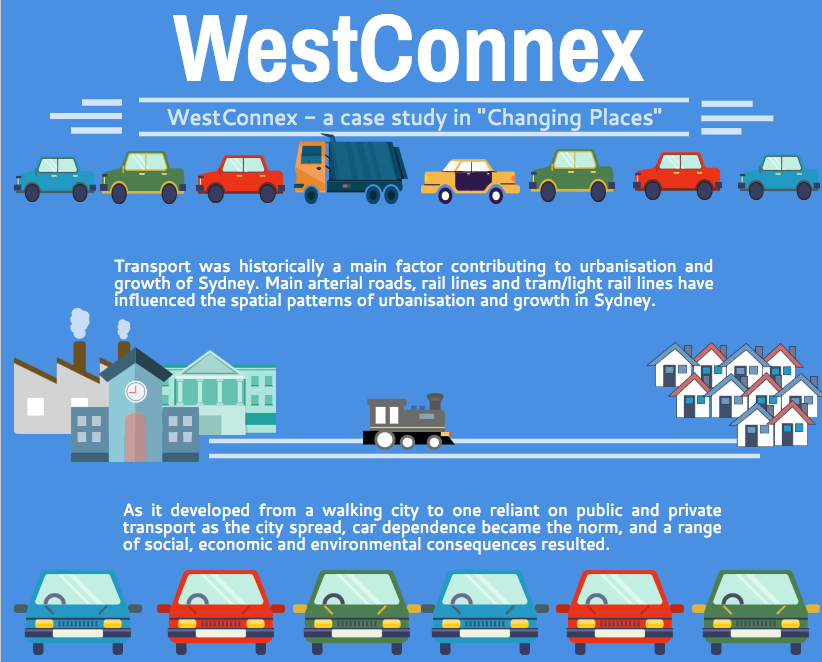 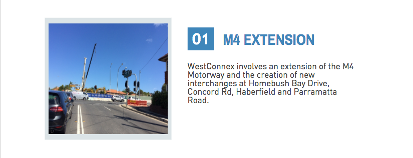  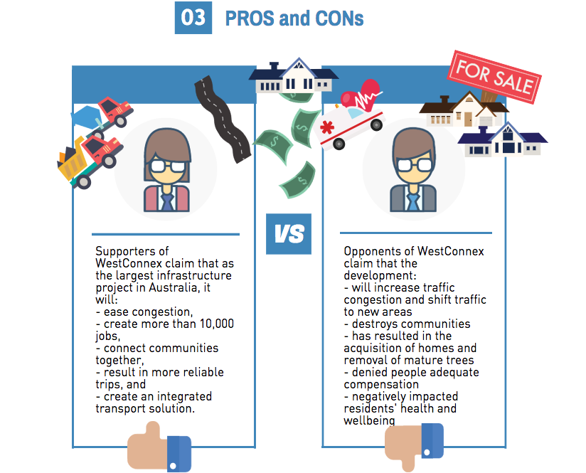 You have been given the job of designing a new city. It will be located at Warnervale on the Central Coast between the M1 and the Pacific Highway. The aim of your city design is to plan the most liveable city possible. Task 1: Brainstorm your ideas and begin planning. Create a list or mind map of all the features that your city will need. At this stage you are just coming up with ideas. You may change your mind as your city design develops.
Task 2: Design your city plan You have been provided with an outline map. Use your mapping rules to begin designing your city. Include border, orientation (north point), a legend, a map title and scale. On your map label the M1 motorway, Sparks Road and the railway line. Draw and label all the key features of your city.  Task 3: Draw your CBD and a residential area.
Construct sketches of how you imagine your city will look like. Annotate your images with important features of your city (style of building, tree-lined streets, community spaces, retail spaces, etc). Task 4: Create a prospectus Write a report that addresses how you have created a "liveable" city. Refer to the questions outlined in Task 1 to help you structure your response. Scan your city plan and CBD and residential area drawings and include them in your prospectus. In 1989, Maxis (later purchased by Electronic Arts) released the first version of SimCity. In junior high school, playing computer games on my dad's computer, I was hooked. I think this is the game that turned me into a lifelong geographer and tech enthusiast. I loved designing cities, experimenting with the parameters of what would make a great city. Even early on I would try to add lots of parks and build the city around the appealing features of the natural environment like rivers, bushland, etc. I would be devastated if one of the natural disasters hit and wiped out parts of my city. As the game progressed over the years it really did get better and better. There were also variants of SimCity released such as SimFarm SimCopter and my favourite spin-off Sim Safari. Unlike a lot of games at the time of its original release (and I would argue even now) SimCity encouraged players to consider multiple interconnecting concepts and ideas, and plan strategically for a result with positive (if virtual) social outcomes. While many "shoot 'em up" games common now do involve strategic planning, for most of them the end result is killing something or someone. This game was a real stand out. Sim CitySim City is a computer game which allows you to build your own city. Sim City requires players to make decisions about both the built and physical environment, and consider the interplay between the different aspects. Through SimCity, players automatically begin to learn the metalanguage of urban planning and urban dynamics - using terms like residential zone, commercial zone, industry, transport infrastructure at the very basic level of the game. After repeated playing, the player begins to learn about the basic needs of a functioning city and its population, about how urban places grow and decline, human behaviour patterns and how even the best laid urban plans can go awry with an unexpected disaster. I will admit the Godzilla natural hazard does test the urban illusions - but it also adds a bit of humour. Natural hazards can be disabled. Lesson idea: Choose one of the following tasks, and outline the challenges that you faced in completing your task:
|
||||||||||||||||||||||||||||||||