HSIE Teachers
  • Home
  • Blog
  • 11 Geography
    • Earth's Natural Systems >
      • Key Terms
      • Processes, cycles and circulations >
        • Atmospheric systems
        • Hydrological systems >
          • Georges River Introduction
          • Georges River
          • Georges River Fieldwork
          • Water Management
          • Flow of Water Though Catchments
          • Catchments - Key Terms
          • Murray-Darling Catchment
          • Human impacts on hydrological processes
        • Geomorphic systems
        • Ecological systems
    • People, Patterns and Processes >
      • Population and resource consumption >
        • Demographic processes
        • Demographic processes - Mortality
        • Population pyramids
        • Challenges of changing population
    • Human-Environment Interactions >
      • A contemporary hazard >
        • Volcanic Eruptions
        • Floods 2022
        • COVID-19
        • Bushfire 2019-2020 >
          • Spatial distribution
          • Managing a contemporary hazard
  • 12 Geography (from 2025)
    • Global Sustainability >
      • Pillars of Sustainability
      • Evaluating Sustainability
      • Tourism - Nature and Spatial Patterns
      • Tourism - Influences >
        • Biophsical Influences
        • Ecological Influences
        • Economic Influences
        • Socio-Cultural Influences
        • Political Influences
        • Organisational Influences
        • Technological Influences
      • Tourism - Trends and Future Directions
      • Tourism - Sustainability >
        • Impacts of Tourism
        • Tourism in Venice
    • Urban and Rural Places >
      • One urban place - Ashbury (suburb) >
        • Ashbury - location and character
        • Ashbury - changes
        • Ashbury - responses to changes
    • Ecosystems and Global Biodiversity >
      • Coral Triangle
  • Geographical Tools
    • Tools Checklist
    • Maps >
      • Topo map basics
      • Area and Grid Reference
      • Sight Lines
      • Bearing
      • Gradient
      • Cross Section
      • Vertical Exaggeration
      • Sketch Maps
      • Synoptic Charts
      • Latitude and Longitude
    • Geographical Inquiry >
      • Soil characteristics
      • Vegetation Profile
      • Fieldsketch
      • Water Quality
      • Microclimate Fieldwork
    • Graphs and Statistics

Spatial distribution of bushfires


Stage 6 content:
Students study one natural hazard to investigate:
- the spatial distribution and nature of the contemporary natural hazard, for example magnitude, frequency, duration, temporal spacing.


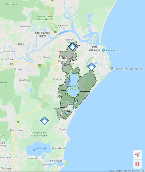
Australian Bushfires 2019-2020 - Lakes Innes and Port Macquarie

Fires around Port Macquarie, Lake Cathie and Lake Innes began in November 2019. As of 21 January the Crestwood Drive, Port Macquarie fire had burnt out 3572ha, while the connected Lindfield Park rd, Port Macquarie fire had burnt out 859ha.

The Lake Innes Nature Reserve  was home to a flourishing koala colony. Between 350 and 600 koalas are believed to have died in the fires around the Lake Innes area.

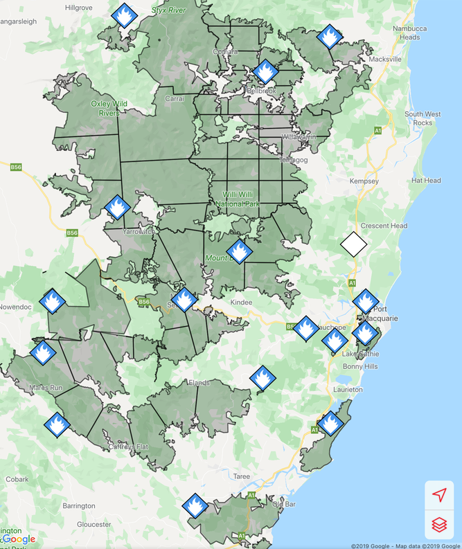
The image on the left is a screenshot of the RFS Fires Near Me app showing the location and extent of the Port Macquarie fires. The screenshot on the right shows the size of the Port Macquarie fires in relation to other fires in the mid-North Coast region.
Picture
Picture
Photos below show the aftermath of the fire - taken on 17 January, 2020.
The post below from NSW National Parks and Wildlife Services indicate that while the fire around Lake Innes was extinguished, there remains risk for future fires flaring even several months later. The post below was posted on January 21.
Powered by Create your own unique website with customizable templates.
  • Home
  • Blog
  • 11 Geography
    • Earth's Natural Systems >
      • Key Terms
      • Processes, cycles and circulations >
        • Atmospheric systems
        • Hydrological systems >
          • Georges River Introduction
          • Georges River
          • Georges River Fieldwork
          • Water Management
          • Flow of Water Though Catchments
          • Catchments - Key Terms
          • Murray-Darling Catchment
          • Human impacts on hydrological processes
        • Geomorphic systems
        • Ecological systems
    • People, Patterns and Processes >
      • Population and resource consumption >
        • Demographic processes
        • Demographic processes - Mortality
        • Population pyramids
        • Challenges of changing population
    • Human-Environment Interactions >
      • A contemporary hazard >
        • Volcanic Eruptions
        • Floods 2022
        • COVID-19
        • Bushfire 2019-2020 >
          • Spatial distribution
          • Managing a contemporary hazard
  • 12 Geography (from 2025)
    • Global Sustainability >
      • Pillars of Sustainability
      • Evaluating Sustainability
      • Tourism - Nature and Spatial Patterns
      • Tourism - Influences >
        • Biophsical Influences
        • Ecological Influences
        • Economic Influences
        • Socio-Cultural Influences
        • Political Influences
        • Organisational Influences
        • Technological Influences
      • Tourism - Trends and Future Directions
      • Tourism - Sustainability >
        • Impacts of Tourism
        • Tourism in Venice
    • Urban and Rural Places >
      • One urban place - Ashbury (suburb) >
        • Ashbury - location and character
        • Ashbury - changes
        • Ashbury - responses to changes
    • Ecosystems and Global Biodiversity >
      • Coral Triangle
  • Geographical Tools
    • Tools Checklist
    • Maps >
      • Topo map basics
      • Area and Grid Reference
      • Sight Lines
      • Bearing
      • Gradient
      • Cross Section
      • Vertical Exaggeration
      • Sketch Maps
      • Synoptic Charts
      • Latitude and Longitude
    • Geographical Inquiry >
      • Soil characteristics
      • Vegetation Profile
      • Fieldsketch
      • Water Quality
      • Microclimate Fieldwork
    • Graphs and Statistics