HSIE Teachers
  • Home
  • Blog
  • 11 Geography
    • Earth's Natural Systems >
      • Key Terms
      • Processes, cycles and circulations >
        • Atmospheric systems
        • Hydrological systems >
          • Georges River Introduction
          • Georges River
          • Georges River Fieldwork
          • Water Management
          • Flow of Water Though Catchments
          • Catchments - Key Terms
          • Murray-Darling Catchment
          • Human impacts on hydrological processes
        • Geomorphic systems
        • Ecological systems
    • People, Patterns and Processes >
      • Population and resource consumption >
        • Demographic processes
        • Demographic processes - Mortality
        • Population pyramids
        • Challenges of changing population
    • Human-Environment Interactions >
      • A contemporary hazard >
        • Volcanic Eruptions
        • Floods 2022
        • COVID-19
        • Bushfire 2019-2020 >
          • Spatial distribution
          • Managing a contemporary hazard
  • 12 Geography
    • Global Sustainability >
      • Pillars of Sustainability
      • Evaluating Sustainability
      • Tourism - Nature and Spatial Patterns
      • Tourism - Influences >
        • Biophsical Influences
        • Ecological Influences
        • Economic Influences
        • Socio-Cultural Influences
        • Political Influences
        • Organisational Influences
        • Technological Influences
      • Tourism - Trends and Future Directions
      • Tourism - Sustainability >
        • Impacts of Tourism
        • Tourism in Venice
    • Urban and Rural Places >
      • One urban place - Ashbury (suburb) >
        • Ashbury - location and character
        • Ashbury - changes
        • Ashbury - responses to changes
    • Ecosystems and Global Biodiversity >
      • Coral Triangle
      • Tundra >
        • McDonald and Heard Island
        • Churchill
  • Geographical Tools
    • Tools Checklist
    • Maps >
      • Topo map basics
      • Area and Grid Reference
      • Sight Lines
      • Bearing
      • Gradient
      • Cross Section
      • Vertical Exaggeration
      • Sketch Maps
      • Synoptic Charts
      • Latitude and Longitude
    • Geographical Inquiry >
      • Soil characteristics
      • Vegetation Profile
      • Fieldsketch
      • Water Quality
      • Microclimate Fieldwork
    • Graphs and Statistics

Ashbury - responses to changes


Stage 6 content:
Urban or rural place case study
- responses to change and strategies for sustainability

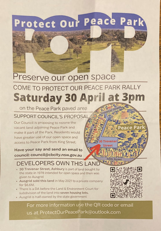
Peace Park development

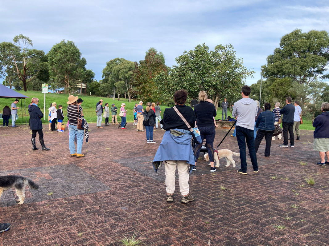
A community protest was held on 30 May 2022 to protest the development of a parcel of land adjacent to Peace Park. The event included guest speakers and was attended by local politicians.

30 Trevenar Street Ashbury is a rectangular parcel of land, of 6,688 sq metres located in the bottom south-west section of Peace Park. The parcel of land was originally owned by the state government, but was given to Ausgrid. When Ausgrid decided to sell the parcel of land Canterbury Council made recommendations that the land be rezoned to open space. 

The land is currently zoned R2 Residential, but both the former owners and real estate agent had been informed that the local council intended to rezone it to RE1 Public Recreation. 

The land was sold to a property developer. ​
Picture
Click to view the Protect Our Peace Park website
Picture
Picture
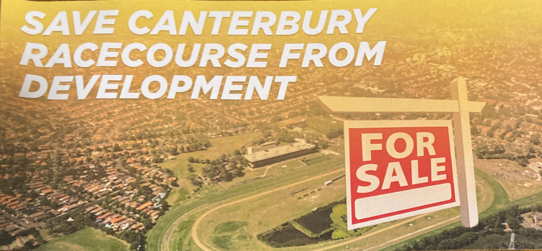
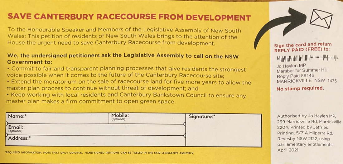
Canterbury racecourse redevelopment

A number of community groups have emerged to communicate community concerns regarding the development of Canterbury Racecourse. These include:

Canterbury Racecourse Action Group
​

Canterbury Racecourse Action Group - submission to Parliament

SydbankAlliance - The battle to save Canterbury Racecourse as open space
​

Canterbury Park Racecourse - Jo Haylen MP
Picture
Picture
Chubb and Tyres4U redevelopment

The Ashbury Community Group was formed in 2015 as a way for local residents to engage with council regarding the Chubb and Tyres4U site rezoning. The group conducted door knocking, hosted regular community meetings, met with council and disseminated information to the community.

​Click to view the Ashbury Community Group website.
​
Powered by Create your own unique website with customizable templates.
  • Home
  • Blog
  • 11 Geography
    • Earth's Natural Systems >
      • Key Terms
      • Processes, cycles and circulations >
        • Atmospheric systems
        • Hydrological systems >
          • Georges River Introduction
          • Georges River
          • Georges River Fieldwork
          • Water Management
          • Flow of Water Though Catchments
          • Catchments - Key Terms
          • Murray-Darling Catchment
          • Human impacts on hydrological processes
        • Geomorphic systems
        • Ecological systems
    • People, Patterns and Processes >
      • Population and resource consumption >
        • Demographic processes
        • Demographic processes - Mortality
        • Population pyramids
        • Challenges of changing population
    • Human-Environment Interactions >
      • A contemporary hazard >
        • Volcanic Eruptions
        • Floods 2022
        • COVID-19
        • Bushfire 2019-2020 >
          • Spatial distribution
          • Managing a contemporary hazard
  • 12 Geography
    • Global Sustainability >
      • Pillars of Sustainability
      • Evaluating Sustainability
      • Tourism - Nature and Spatial Patterns
      • Tourism - Influences >
        • Biophsical Influences
        • Ecological Influences
        • Economic Influences
        • Socio-Cultural Influences
        • Political Influences
        • Organisational Influences
        • Technological Influences
      • Tourism - Trends and Future Directions
      • Tourism - Sustainability >
        • Impacts of Tourism
        • Tourism in Venice
    • Urban and Rural Places >
      • One urban place - Ashbury (suburb) >
        • Ashbury - location and character
        • Ashbury - changes
        • Ashbury - responses to changes
    • Ecosystems and Global Biodiversity >
      • Coral Triangle
      • Tundra >
        • McDonald and Heard Island
        • Churchill
  • Geographical Tools
    • Tools Checklist
    • Maps >
      • Topo map basics
      • Area and Grid Reference
      • Sight Lines
      • Bearing
      • Gradient
      • Cross Section
      • Vertical Exaggeration
      • Sketch Maps
      • Synoptic Charts
      • Latitude and Longitude
    • Geographical Inquiry >
      • Soil characteristics
      • Vegetation Profile
      • Fieldsketch
      • Water Quality
      • Microclimate Fieldwork
    • Graphs and Statistics