HSIE Teachers
  • Home
  • Blog
  • 11 Geography
    • Earth's Natural Systems >
      • Key Terms
      • Processes, cycles and circulations >
        • Atmospheric systems
        • Hydrological systems >
          • Georges River Introduction
          • Georges River
          • Georges River Fieldwork
          • Water Management
          • Flow of Water Though Catchments
          • Catchments - Key Terms
          • Murray-Darling Catchment
          • Human impacts on hydrological processes
        • Geomorphic systems
        • Ecological systems
    • People, Patterns and Processes >
      • Population and resource consumption >
        • Demographic processes
        • Demographic processes - Mortality
        • Population pyramids
        • Challenges of changing population
    • Human-Environment Interactions >
      • A contemporary hazard >
        • Volcanic Eruptions
        • Floods 2022
        • COVID-19
        • Bushfire 2019-2020 >
          • Spatial distribution
          • Managing a contemporary hazard
  • 12 Geography (from 2025)
    • Global Sustainability >
      • Pillars of Sustainability
      • Evaluating Sustainability
      • Tourism - Nature and Spatial Patterns
      • Tourism - Influences >
        • Biophsical Influences
        • Ecological Influences
        • Economic Influences
        • Socio-Cultural Influences
        • Political Influences
        • Organisational Influences
        • Technological Influences
      • Tourism - Trends and Future Directions
      • Tourism - Sustainability >
        • Impacts of Tourism
        • Tourism in Venice
    • Urban and Rural Places >
      • One urban place - Ashbury (suburb) >
        • Ashbury - location and character
        • Ashbury - changes
        • Ashbury - responses to changes
    • Ecosystems and Global Biodiversity >
      • Coral Triangle
  • Geographical Tools
    • Tools Checklist
    • Maps >
      • Topo map basics
      • Area and Grid Reference
      • Sight Lines
      • Bearing
      • Gradient
      • Cross Section
      • Vertical Exaggeration
      • Sketch Maps
      • Synoptic Charts
      • Latitude and Longitude
    • Geographical Inquiry >
      • Soil characteristics
      • Vegetation Profile
      • Fieldsketch
      • Water Quality
      • Microclimate Fieldwork
    • Graphs and Statistics

HSIETeachers.com

Ideas, resources, inspiration

Lesson 7: Contributing to a sustainable future

7/27/2017

0 Comments

 
This is part of a unit of work for Changing Places - Australia's Urban Future.

Lesson 1: Australia's Projected Population Growth
Lesson 2: Implications for Future Growth and Sustainability
Lesson 3: Sydenham to Bankstown Urban Renewal Precinct
Lesson 4: WestConnex - Sydney, Sustainability and Transport
Lesson 4: Sydney Sustainability and Transport (Teacher's Notes)
​Lesson 5: The GreenWay
​
Lesson 5: Deindustrialisation
Lesson 6: Create an infographic
Lesson 7: Contributing to a Sustainable Urban Future
Lesson 7: WestConnex - Protest Movements and Impacts
Lesson 7: Conflict Over Dulwich Hill

OR See the ​complete unit on the Changing Places website.
​

Social Movements
​

Social movements can provide residents of a community with a means of influencing their local environment. They provide a way for residents to communicate opinions on planning and other matters to the formal planning structures and organisations, and to intervene in the formal political system. Activities of social movements can include letter-writing campaigns, protest meetings, and media campaigns.
Social movements can be important agents of urban change and can empower local communities. An example of a social movement is the urban cycling movement which aims to reduce car dependence and improve sustainability of transport, increase safety on roads for cyclists and encourage a collective increase in personal health and wellbeing through exercise. 
Picture

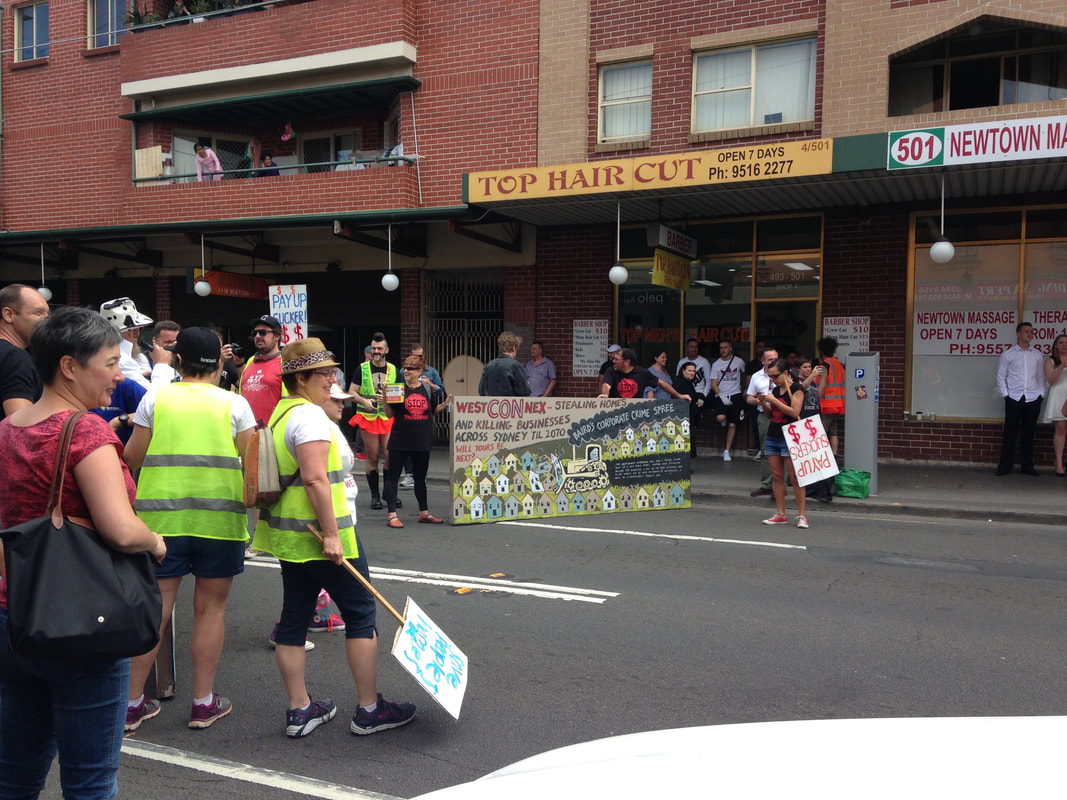
​Resident Action Groups

 
Resident Action Groups are a form of social movement at a smaller scale, and usually involve issues of a short term nature. RAGs often tend to be localized and single-focused. Although these groups are usually designed to force significant changes in society as a whole, they can at times bring about change at a smaller scale. Unlike social movements more generally, RAGs are more obviously limited and can be interpreted as having NIMBY (not in my backyard) motives. Recent transport infrastructure development and proposals for high density throughout the Inner West of Sydney have created an increase in the number of RAGs and concentrated the patterns of RAGs around development sites.  There are currently a large number of Resident Action Groups in the Inner West of Sydney protesting and lobbying against WestConnex and increased development. Examples include Rozelle Against WestConnex, Save Dully, and Newtown WestConnex Action Group.
​Rozelle Against WestConnex
​The Rozelle Against WestConnex group lobbies against WestConnex in general, but more specifically the Rozelle Interchange in the vicinity of the Rozelle Goods Yard, as well as the tunnels running below Denison and Darling Streets. This will involve acquisition and demolition of homes and businesses and creation of 12-metre high, unfiltered smoke stacks.
Save Dully
​The Save Dulwich Hill Community Group promotes issues related to the redevelopment of the suburbs and lobbies the government to preserve the heritage of suburb. Visit the Save Dully website to read more about their actions. Dulwich Hill experienced growth in the late 1800s following the introduction of the tram line, and as a result contains buildings with heritage architecture, particularly Federation architecture. The Sydenham to Bankstown Urban Renewal Strategy, encompasses the suburb of Dulwich Hill, rezoning for higher density and redevelopment of older buildings. Save Dully is lobbying to ensure that the historic and diverse nature of Dulwich Hill is preserved.
​Newtown WestConnex Action Group
The M4-M5 link tunnels will run underneath Newtown. Many Newtown business owners have begun protesting the development, worried that congestion and bottlenecks will negatively impact retail businesses, or alternatively that clearways along King St will kill business. The Newtown WestConnex Action Group has been formed. In Alexandria a new bridge is being constructed over the canal to allow movement of traffic from the St Peters interchange.
Lesson Idea: Individual and community action
​

Examine the ways that individuals and communities have contributed to the political process and discussions about the WestConnex project. Write a paragraph about 5 actions taken by individuals and communities. Do you think these have been effective? Do you think these actions are justified? What other actions could individuals or communities take?

Examine a video of a council meeting about West Connex (try a simple search on Youtube). Consider how the different groups and individuals perceive how WestConnex impacts their community and/or environment. Choose a persona from one of the following: local resident, local councilor, construction worker, urban planner. Write a series of tweets that you might compose to tell your feelings and opinions about the issue.
 
Take photographs of a site that will be or has been affected by WestConnex. You may use Google Street View if you are not close by to a relevant site. Annotate the photographs showing how features of the environment have changed or will change as a result of the WestConnex development.
Assess how the changes to the site will impact on its environmental quality.
 
Obtain aerial photographs of the Inner West of Sydney (these may be screen shots from Google Maps). Visually represent the changes that are taking place in the area. Annotate the aerial photographs showing locations affected by Planned Precincts, WestConnex and the Metroline. Include detail about the types of changes that are going to take place. 

Fieldwork: Questionnaire
​

Conduct a questionnaire on residents that live in the Inner West of Sydney. Design 8-10 questions to ask. Some examples:
  • Do you have concerns about the WestConnex development?
  • What might be the benefits of WestConnex?
Tabulate and analyse the results of your survey. What do the findings tell you about perceptions of WestConnex in the Inner West.
0 Comments

Lesson 7: Conflict over development of Dulwich Hill

7/16/2017

0 Comments

 
This is part of a unit of work for Changing Places - Australia's Urban Future.

Lesson 1: Australia's Projected Population Growth
Lesson 2: Implications for Future Growth and Sustainability
Lesson 3: Sydenham to Bankstown Urban Renewal Precinct
Lesson 4: WestConnex - Sydney, Sustainability and Transport
Lesson 4: Sydney Sustainability and Transport (Teacher's Notes)
​Lesson 5: The GreenWay
​
Lesson 5: Deindustrialisation
Lesson 6: Create an infographic
Lesson 7: Contributing to a Sustainable Urban Future
Lesson 7: WestConnex - Protest Movements and Impacts
Lesson 7: Conflict Over Dulwich Hill

​
OR See the ​complete unit on the Changing Places website.
​
​
Dulwich Hill is a suburb located in Sydney's Inner West, surrounded by Summer Hill, Hurlstone Park, Marrickville, Petersham, Lewisham and Earlwood. It experienced growth in the late 1800s following the introduction of the tram line, and as a result contains buildings with heritage architecture, particularly Federation architecture.

The tram line through Dulwich Hill was not in use as public transport from the 1950s. The Inner West light rail extension in 2013 reconnected Dulwich Hill by rail with nearby suburbs and the city. For more details see my previous post Inner West Light Rail Extension. 

For more information about the history and development of Dulwich Hill, visit the Dulwich Hill section of the Marrickville historical society - Dulwich Hill - a history.

The Sydenham to Bankstown Urban Renewal Strategy, encompasses the suburb of Dulwich Hill, rezoning for higher density and redevelopment of older buildings. Changes to zoning as part of this strategy can be seen on the Planning NSW website - Dulwich Hill Landuse Plan. The plan for Dulwich Hill includes 2000 more dwellings, with 3 storey development along Wardell Road, and unit developments from 3-5 storeys near the Dulwich Hill station. Higher density housing developments are zoned for around the Dulwich Hill light rail station (between 3-7 storeys). 8 storey developments will be allowed around Arlington Grove Light Rail station.

View the Changing Places - Sydenham to Bankstown Urban Renewal Precinct post.

The Save Dulwich Hill Community Group promotes issues related to the redevelopment of the suburbs and lobbies the government to preserve the heritage of suburb. Visit the Save Dully website to read more about their actions.

0 Comments

Changing Places - Redevelopment of Canterbury Racecourse

7/16/2017

0 Comments

 
Recent new indicates that Canterbury Racecourse is likely to be sold to make way for a large housing development. 
​
Sydney's Canterbury racecourse could be the city's next major apartment development.

High-rise apartments on the cards for Canterbury racecourse.

Australian Turf Club confirms plans to redevelop parcel of land at Canterbury Racecourse, but racing to continue.

Canterbury racecourse rezoning a "one-off opportunity" turf club chairman says. 

​The future of Canterbury Racecourse - Turfmate

Mirvac wins right to develop Australian Turf Club's Canterbury Park racecourse land.

Sydney's Canterbury racecourse could be the city's next major apartment development.

"It's like a DMZ": Car park DA prompts development fears for Canterbury racecourse.

Fears as developers eye-up Canterbury Park racecourse.

​
High rise apartments on the cards for Canterbury Racecourse.
0 Comments

Liveability - Design a city

7/1/2017

1 Comment

 
You have been given the job of designing a new city. It will be located at Warnervale on the Central Coast between the M1 and the Pacific Highway. The aim of your city design is to plan the most liveable city possible.

Task 1: Brainstorm your ideas and begin planning.
Create a list or mind map of all the features that your city will need. At this stage you are just coming up with ideas. You may change your mind as your city design develops.
  1. What transport infrastructure will you provide? What main roads will you have? Will the roads be in a grid structure to facilitate movement, or will you direct traffic by having irregular patterns? What public transport will your city have? Will it have light rail, heavy trail, buses, etc? How will you encourage people to walk or use bicycles? What areas of your city need to be connected by public transport? How will you connect your city with surrounding areas, regional cities and Sydney?
  2. What electricity, water, sewerage and telecommunications infrastructure will you provide? How will the services be laid out? Will/does the city have its own sources of water (dams, water tanks, rivers, etc). How will you provide power (e.g power plant, solar panels, wind turbines, etc)?
  3. What type of housing will your city have? What have we learnt about how density impacts on services, transport, etc? Will your city have low density, medium density or high density housing (the mix/combination)? What will the buildings look like (style of architecture)? Will you have regulations in place to ensure that the buildings are both liveable and sustainable (e.g. minimum/maximum size backyards, minimum/maximum sized houses, rules about mature trees and gardens, etc)?
  4. What will the main commercial centre of the city be like? Where will it be located? Will most retail areas be located in a shopping centre, in malls or on a main street? What types of commercial/ retail outlets will be there (what types of shops)? What will the main street look like? What other types of businesses will you try to attract to the Central Business District (CBD)?
  5. What types of community facilities will be provided in your city (e.g. health, education, aged care, etc)? How will you make sure that the facilities and services provided are of a high quality? How will you ensure that people can access them? How will you make sure that they are affordable?
  6. What public spaces will you provide, (e.g. parks, monuments, Nature Reserves, etc)? How can you make sure that they are safe, well kept, clean and useable? How will you encourage people to use these spaces? Can you use any of these spaces to conserve the environment and provide public access?

Task 2: Design your city plan
You have been provided with an outline map. Use your mapping rules to begin designing your city. Include border, orientation (north point), a legend, a map title and scale. On your map label the M1 motorway, Sparks Road and the railway line. Draw and label all the key features of your city.

Picture

Task 3: Draw your CBD and a residential area. 
Construct sketches of how you imagine your city will look like. Annotate your images with important features of your city (style of building, tree-lined streets, community spaces, retail spaces, etc).

Task 4: Create a prospectus
Write a report that addresses how you have created a "liveable" city. Refer to the questions outlined in Task 1 to help you structure your response. Scan your city plan and CBD and residential area drawings and include them in your prospectus.
1 Comment
    12 Geography
    11 Geography
    Geography Skills
    Legal Studies
    Studies of Religion
    Commerce
    History
    Changing Places
    Environmental Change

    Categories

    All
    10 Geography
    11 Geo
    11 Geography
    12 Geography
    12 Legal Studies
    6 Geography
    7 Geography
    8 Geography
    9 Geography
    Aboriginal Culture
    Aboriginal Education
    Accreditation
    Adani
    Affordability
    AGTA2017
    AGTA 2022
    AGTA 2024
    AI
    Ancient History
    ANZAC
    App
    Arctic
    Ashbury
    Asia
    Augmented Reality
    Australian Curriculum
    Australians At War
    Balmain Foreshore Project
    Biomes
    Biophysical Interactions
    Biosphere
    Both Ways
    Buddhism
    Bush Care
    Bushfires
    Business Studies
    BYOD
    Cabramatta
    Case Studies
    Catchment
    Catchment Functioning
    Change
    Changing Places
    ChatGPT
    Citizenship
    Climate Change
    Coastal Geography
    Cold War
    Collaboration
    Commerce
    Consumer Choice
    Contemporary Hazard
    Coral Reefs
    Cross Curriculum Priorities
    Cross Curriculum Project
    Cultural Integration
    Curriculum Reform
    Deputy Principal
    Differentiation
    Discrimination
    Economic Activity
    Ecosystem Restoration
    Ecosystems At Risk
    Elearning
    Elective Geography
    Environmental Change
    Excursion
    Faculty
    Fertility
    Fieldwork
    Fluvial
    Forest
    Gaming
    General Capabilities
    Geographical Investigation
    Geography
    Geomorphic Hazards
    Georges River
    Global
    Google
    Great Barrier Reef
    GTAConference2024
    GTANSW2017
    GTA NSW Conference 2018
    Herculanuem
    Historiography
    History
    Homelessness
    Housing
    HSC
    Human Environment Interactions
    Human Rights
    India
    Insurance
    Kakadu
    Leadership
    Learning Across The Curriculum
    Learning And Support
    Legal Studies
    Legal Studies Association
    Life Skills
    Light Rail
    Literacy
    Liveability
    Management
    Mekong
    Metroline
    Mining
    Modern History
    Modifications
    Natural Hazards
    Natural Resources
    Natural Systems
    New Nsw Syllabus
    New Syllabus
    Online Learning
    Outcomes
    Papua New Guinea
    PBL
    Personal Finance
    Picture Books
    Place And Liveability
    Population
    Population Pyramids
    Precis
    Preliminary
    Primary
    Principal
    Problem Based Learning
    Professional Associations
    Professional Learning
    Program
    Project Based Learning
    Purpose
    Refugees
    Reporting
    Revision
    Rivers
    Rock Art
    Sea Level Rise
    Senior Geography Project
    SGP
    Shelter
    Sia
    Skills
    Social Media
    Solutions
    Stage 3
    Stage 4
    Stage 5
    Stage 6
    Studies Of Religion
    Sustainability
    Sydenham To Bankstown
    Sydney
    Teacher Visioning
    Teacher Wellbeing
    Tech
    Technology
    Tourism
    Transport
    Travel
    Urbanisation
    Urban Places
    Venice
    Video
    Virtual Reality
    Visible Leadership
    Vision
    Volcanoes
    WestConnex
    World
    World Cities
    World Heritage Sites
    Writing
    WWI
    WWII
    Year 10
    Year 9

    Archives

    December 2024
    October 2024
    September 2024
    May 2024
    April 2024
    December 2023
    October 2023
    September 2023
    August 2023
    June 2023
    May 2023
    April 2023
    March 2023
    February 2023
    January 2023
    December 2022
    September 2022
    August 2022
    July 2022
    May 2022
    April 2022
    June 2021
    March 2021
    April 2020
    February 2020
    January 2020
    July 2019
    June 2019
    May 2019
    April 2019
    March 2019
    February 2019
    June 2018
    March 2018
    February 2018
    October 2017
    August 2017
    July 2017
    May 2017
    April 2017
    March 2017
    February 2017
    January 2017
    December 2016
    November 2016
    September 2016
    August 2016
    July 2016
    June 2016
    May 2016
    April 2016
    December 2015
    August 2015
    July 2015
    June 2015
    May 2015
    February 2015
    December 2014
    October 2014
    August 2014
    July 2014
    June 2014
    May 2014
    March 2014
    February 2014
    December 2013
    November 2013
    October 2013
    September 2013
    August 2013
    July 2013
    June 2013
    May 2013
    April 2013

Powered by Create your own unique website with customizable templates.
  • Home
  • Blog
  • 11 Geography
    • Earth's Natural Systems >
      • Key Terms
      • Processes, cycles and circulations >
        • Atmospheric systems
        • Hydrological systems >
          • Georges River Introduction
          • Georges River
          • Georges River Fieldwork
          • Water Management
          • Flow of Water Though Catchments
          • Catchments - Key Terms
          • Murray-Darling Catchment
          • Human impacts on hydrological processes
        • Geomorphic systems
        • Ecological systems
    • People, Patterns and Processes >
      • Population and resource consumption >
        • Demographic processes
        • Demographic processes - Mortality
        • Population pyramids
        • Challenges of changing population
    • Human-Environment Interactions >
      • A contemporary hazard >
        • Volcanic Eruptions
        • Floods 2022
        • COVID-19
        • Bushfire 2019-2020 >
          • Spatial distribution
          • Managing a contemporary hazard
  • 12 Geography (from 2025)
    • Global Sustainability >
      • Pillars of Sustainability
      • Evaluating Sustainability
      • Tourism - Nature and Spatial Patterns
      • Tourism - Influences >
        • Biophsical Influences
        • Ecological Influences
        • Economic Influences
        • Socio-Cultural Influences
        • Political Influences
        • Organisational Influences
        • Technological Influences
      • Tourism - Trends and Future Directions
      • Tourism - Sustainability >
        • Impacts of Tourism
        • Tourism in Venice
    • Urban and Rural Places >
      • One urban place - Ashbury (suburb) >
        • Ashbury - location and character
        • Ashbury - changes
        • Ashbury - responses to changes
    • Ecosystems and Global Biodiversity >
      • Coral Triangle
  • Geographical Tools
    • Tools Checklist
    • Maps >
      • Topo map basics
      • Area and Grid Reference
      • Sight Lines
      • Bearing
      • Gradient
      • Cross Section
      • Vertical Exaggeration
      • Sketch Maps
      • Synoptic Charts
      • Latitude and Longitude
    • Geographical Inquiry >
      • Soil characteristics
      • Vegetation Profile
      • Fieldsketch
      • Water Quality
      • Microclimate Fieldwork
    • Graphs and Statistics