HSIE Teachers
  • Home
  • Blog
  • 11 Geography
    • Earth's Natural Systems >
      • Key Terms
      • Processes, cycles and circulations >
        • Atmospheric systems
        • Hydrological systems >
          • Georges River Introduction
          • Georges River
          • Georges River Fieldwork
          • Water Management
          • Flow of Water Though Catchments
          • Catchments - Key Terms
          • Murray-Darling Catchment
          • Human impacts on hydrological processes
        • Geomorphic systems
        • Ecological systems
    • People, Patterns and Processes >
      • Population and resource consumption >
        • Demographic processes
        • Demographic processes - Mortality
        • Population pyramids
        • Challenges of changing population
    • Human-Environment Interactions >
      • A contemporary hazard >
        • Volcanic Eruptions
        • Floods 2022
        • COVID-19
        • Bushfire 2019-2020 >
          • Spatial distribution
          • Managing a contemporary hazard
  • 12 Geography (from 2025)
    • Global Sustainability >
      • Pillars of Sustainability
      • Evaluating Sustainability
      • Tourism - Nature and Spatial Patterns
      • Tourism - Influences >
        • Biophsical Influences
        • Ecological Influences
        • Economic Influences
        • Socio-Cultural Influences
        • Political Influences
        • Organisational Influences
        • Technological Influences
      • Tourism - Trends and Future Directions
      • Tourism - Sustainability >
        • Impacts of Tourism
        • Tourism in Venice
    • Urban and Rural Places >
      • One urban place - Ashbury (suburb) >
        • Ashbury - location and character
        • Ashbury - changes
        • Ashbury - responses to changes
    • Ecosystems and Global Biodiversity >
      • Coral Triangle
  • Geographical Tools
    • Tools Checklist
    • Maps >
      • Topo map basics
      • Area and Grid Reference
      • Sight Lines
      • Bearing
      • Gradient
      • Cross Section
      • Vertical Exaggeration
      • Sketch Maps
      • Synoptic Charts
      • Latitude and Longitude
    • Geographical Inquiry >
      • Soil characteristics
      • Vegetation Profile
      • Fieldsketch
      • Water Quality
      • Microclimate Fieldwork
    • Graphs and Statistics

HSIETeachers.com

Ideas, resources, inspiration

White Island

1/20/2020

0 Comments

 
Picture
The White Island disaster
On 9 December 2019, Whakaari, or White Island in New Zealand erupted while 47 people were on the island. It is located 48 km off the coast of New Zealand’s North Island. 47 people were on the island at the time of the eruption. 21 people were killed and 26 people suffered injuries including severe burns and inhalation burns.

Whakaari/White Island is one of New Zealand’s most active volcanoes, and is expected to have explosive eruptions every few decades. The island experienced its longest eruption episode between 1975 and 200, and has since erupted in 2012, 2013 and 2016. The island is privately owned, and was used as a unique site for adventure tourism, enabling visitors the opportunity to visit the caldera of an active volcano. 
Picture
Picture
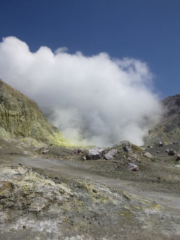
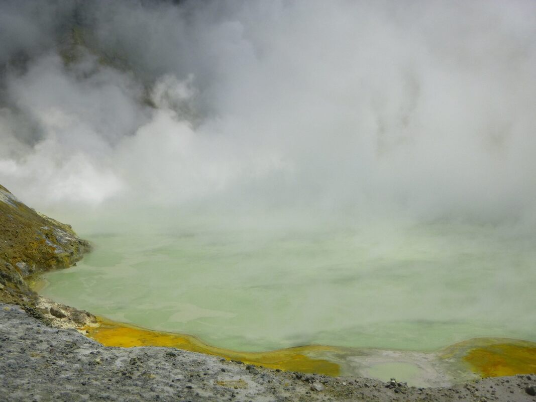
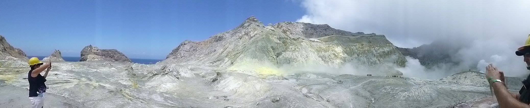
Tourists could fly to the island by helicopter or travel by boat, and were then required to wear a hard hat and gas mask to do the tour of the site on foot. The annual revenue generated by White Island Tours for the local Maori tribe, Ngati Awa was $NZ4.5 million.The nearby town of Whakatane in the Bay of Plenty is the gateway to Whakaari and is a town of approximately 34,000. During holiday season, the town becomes packed with caravans, and the motels, hotel, restaurants are full of tourists. Tourism is the lifeblood of the town.

Geomorphic processes that caused the disaster 

New Zealand is particularly tectonically active, and earthquakes and volcanoes are common. Whaakari/White Island is a typical open vent volcanic system with magma not too far below the surface. The volcano is extremely volatile. It has a crater system enclosed within the crater, it has a superheated crater lake, there are noxious gases escaping from the gas vents, and there have been previous explosive eruptions. The eruption that occurred is known as an hydrothermal eruption, with the volcano spewing gas at temperatures at a minimum of 200 degrees celcius.
Picture
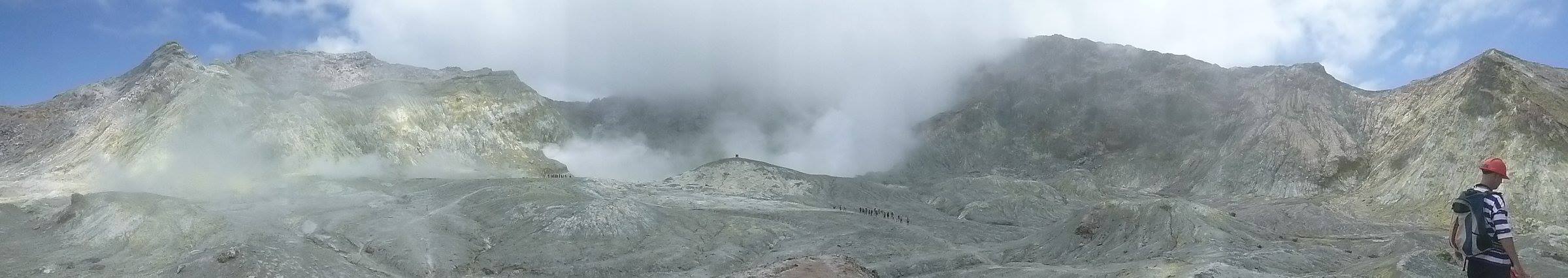
Responses to the disaster

Immediately following the disaster, the local tribes imposed a rahui, a cultural ban, on the waters along the coast following the explosion. In addition, a maritime exclusion zone of 5km around the island was imposed following the event, to provide exclusive access to police and the defence force. Tour boats were quarantined. A no-fly zone was also ordered after the eruption. Police and the Defence Force, including six bomb disposal specialists were involved in rescue and recovery operations. 
​
The island was heavily toxic following the eruption. Initial visits were very short, with teams using breathing equipment to allow them to search for up to 75 minutes at a time. They needed to wear three protective layers and wade through dense acidic mud. Recovery divers had to be washed clean following recovery dives due to the acidity of the water. 

Management strategies to reduce impacts of similar hazard events in the future

Tours which allow walking around the volcanic island no longer run. There are some scenic flights which allow a view of the island from a distance.
GNS Science undertake research on natural Earth system processes and resources, and are New Zealand’s geological hazards information authority. GNS Science and the Earthquake Commission work together to provide information through the GeoNet website. It monitors volcanic activity using seismometers, acoustic sensors and webcams. Samples are also collected from the island frequently. This ongoing monitoring and assessment provides the public with information about the changing risk level for the volcano. GeoNet uses Volcano Alert Bulletins to asses the rick of the volcano.

The Bay of Plenty Civil Defence Emergency Management group has overall responsibility for managing hazards and risks associated with Whakaari/White Island. They have developed a Whakaari/White Island Response Plan. This was developed in December 2019, and specified the roles and responsibility of different groups and agencies in the event of a similar disaster.

Tour operators are required to regularly communicate with each other to share knowledge of observations on the island, they need to directly communicate with GNS, and need to carry out their own individual risk assessment on each landing on the island. Information about the risks associated with walking around and active volcano is communicated to any visitors to the site.

1. Describe the location of Whakaari/White Island.
2. Describe how White Island was used by people.
3. Outline the impacts of the White Island disaster.
4. Examine figure 1. Explain the geomorphic processes that caused the disaster on White Island.
5. Explain the difficulties in the rescue and recovery mission on White Island following the eruption.
6. Propose the key points to be considered in developing a risk management plan for use of White Island in the future.
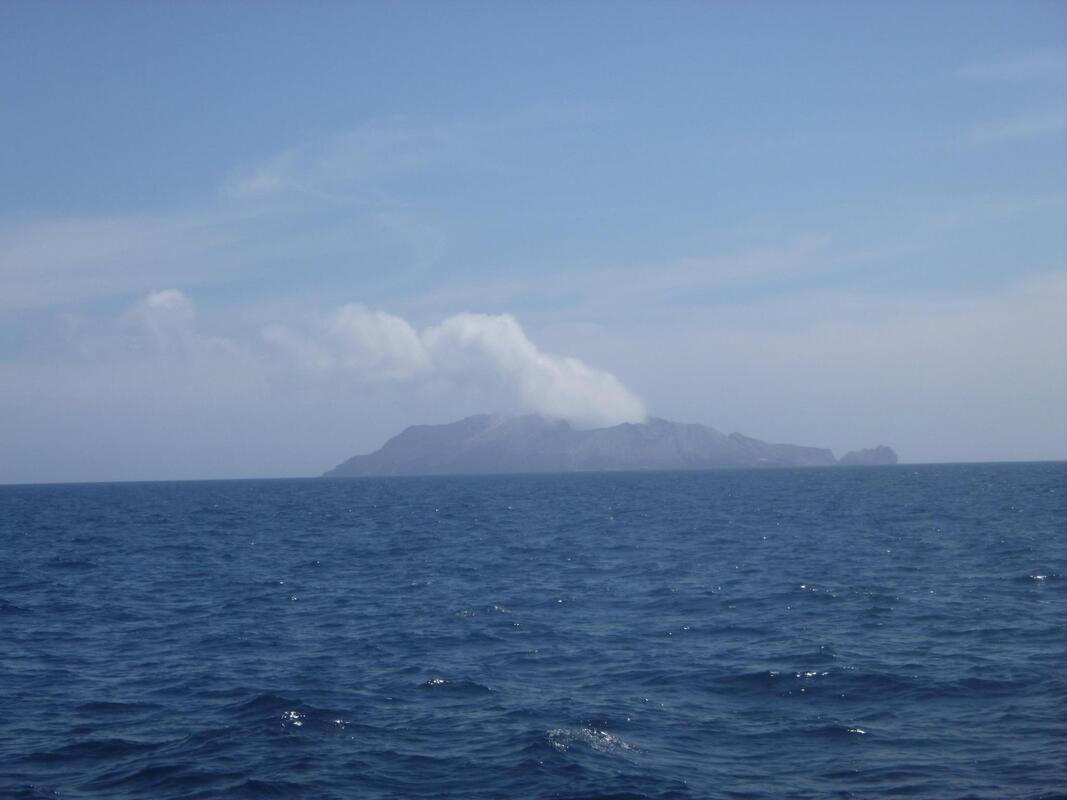
Picture
0 Comments

Geomorphic processes

10/10/2017

0 Comments

 
Geomorphology: the study of landforms, their origins, evolution, form and distribution.

The lithosphere is the outer shell of the earth, consisting of soil and geological formations. The earth is made up of different section: the core, the inner core, the outer core and the crust. Study of the lithosphere is primarily concerned with the crust.

The two sets of forces which shape the earth’s crust are tectonic forces (continental drift and plate movement at a smaller scale), and gradational forces (weathering, erosion, deposition and mass movement).

Landforms can be shaped in a number of ways:
  • By water – through the processes of hydraulic action, abrasion, and corrosion
  • By wind – through the processes of abrasion and deflation
  • By ice – through continual erosion and deposition, abrasion.
​
Click to read Mystery island in the Southern Pacific brimming with life.
​
Slip, Slide Colide
​Click to play Slip, Slide Collide
Picture
Picture
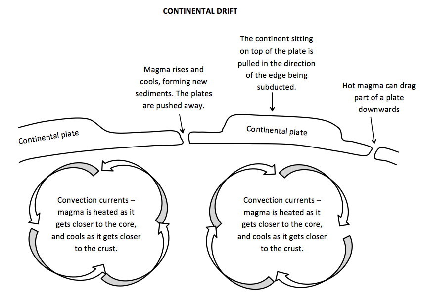
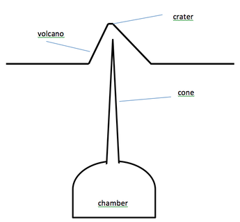
Volcanoes

Volcanoes involve the process of molten rock from the mantle being forced up onto the earth’s surface, building continents.

Folding

Fold mountains like the Himalayas, form when the Earth’s plates crunch into each other, and layers of the crust are pushed up into loops and bumps.
Picture
Earthquakes

When two plates come together, folding and faulting can occur which can cause earthquakes (see above). Earthquakes occur as a result of movement between sections of the earth’s crust. They commonly occur along fault lines and along plate boundaries. Sections of tectonic plates can be forced upwards exposing new sections.
Picture
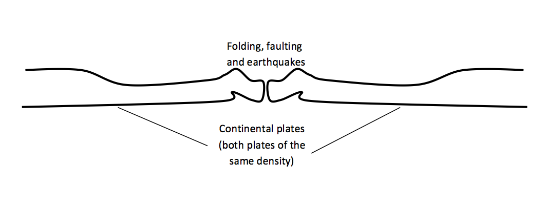
​Converging plates

When plates come together (or converge) underwater trenches and volcanoes can be formed.

Picture
Picture
Picture
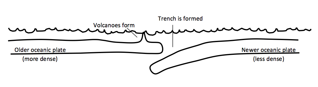
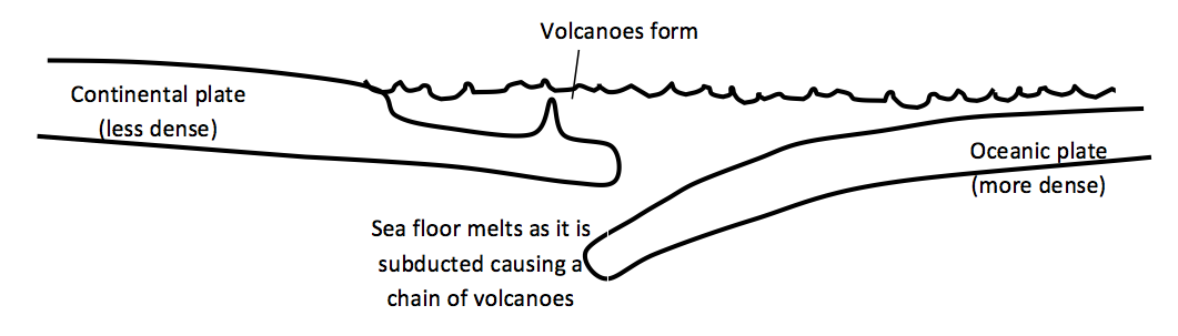
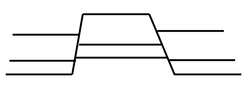
Faulting - Block mountains

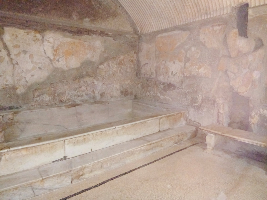
Block mountains are made when part of the crust is forced up between two cracks in a plate. These cracks are called faults. ​

0 Comments

Herculanuem

6/13/2014

0 Comments

 
We visited Herculaneum today. We were approached by a woman who introduced herself as an archaeologist working on the site and asked if we would like a tour with her. Conchetta (Connie) was fantastic. The depth of knowledge added so much to the experience. She took us underground to an excavated pool, pointed out restoration efforts, showed us areas where items had been removed and so on. We loved every minute of it. Connie was really engaging and obviously enjoyed  presenting her work, and as a result she really passed on her enthusiasm to us.

When Mt Vesuvius erupted it threw out a gigantic cloud of volcanic ash 30 km into the sky. Herculaneum was also impact by earthquakes. Hot ash and gas rolled down the slope of the volcano burying Herculanuem underground, in some places as deep as 23 metres. Over time Herculaneum was looted with many pieces of marble and bronze statues taken.
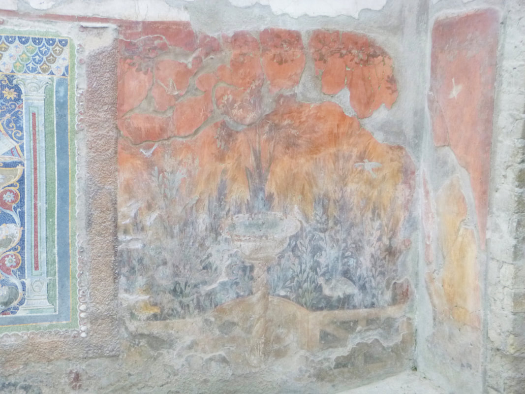
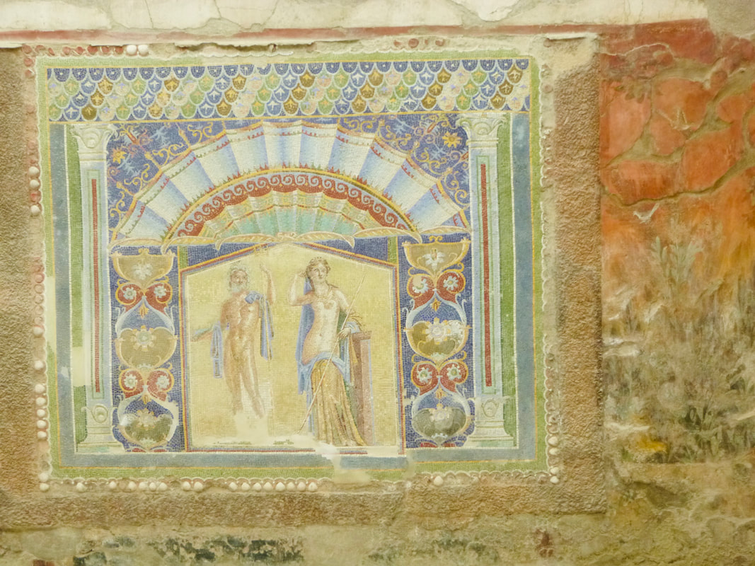
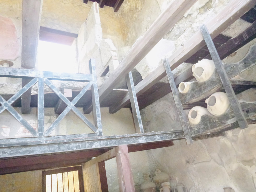
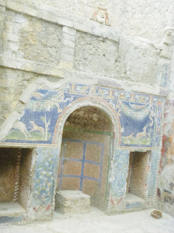
Picture
Picture
Picture
Picture
Picture
The hot room - caldarium

There is.a large marble bath for users to have a hot bath and then a podium for cold or tepid water. The walls contain smoke and heat vents. There are marble benches alongside the bath. Ceilings and wall were stucco.

The central baths - apodyterium

​Black and white mosaic tiles on the floor in the changing room or apodyterium of the women's central baths depict Triton, the son of Neptune surrounded by marine creatures including an octopus, leaping dolphins, polyps and eels. The baths have recessed seating and a shelf around the edges for clothing and small items. Walls were stucco.


​See a plan of Herculaneum.

See more photos of Herculanuem.


Picture
0 Comments
    12 Geography
    11 Geography
    Geography Skills
    Legal Studies
    Studies of Religion
    Commerce
    History
    Changing Places
    Environmental Change

    Categories

    All
    10 Geography
    11 Geo
    11 Geography
    12 Geography
    12 Legal Studies
    6 Geography
    7 Geography
    8 Geography
    9 Geography
    Aboriginal Culture
    Aboriginal Education
    Accreditation
    Adani
    Affordability
    AGTA2017
    AGTA 2022
    AGTA 2024
    AI
    Ancient History
    ANZAC
    App
    Arctic
    Ashbury
    Asia
    Augmented Reality
    Australian Curriculum
    Australians At War
    Balmain Foreshore Project
    Biomes
    Biophysical Interactions
    Biosphere
    Both Ways
    Buddhism
    Bush Care
    Bushfires
    Business Studies
    BYOD
    Cabramatta
    Case Studies
    Catchment
    Catchment Functioning
    Change
    Changing Places
    ChatGPT
    Citizenship
    Climate Change
    Coastal Geography
    Cold War
    Collaboration
    Commerce
    Consumer Choice
    Contemporary Hazard
    Coral Reefs
    Cross Curriculum Priorities
    Cross Curriculum Project
    Cultural Integration
    Curriculum Reform
    Deputy Principal
    Differentiation
    Discrimination
    Economic Activity
    Ecosystem Restoration
    Ecosystems At Risk
    Elearning
    Elective Geography
    Environmental Change
    Excursion
    Faculty
    Fertility
    Fieldwork
    Fluvial
    Forest
    Gaming
    General Capabilities
    Geographical Investigation
    Geography
    Geomorphic Hazards
    Georges River
    Global
    Google
    Great Barrier Reef
    GTAConference2024
    GTANSW2017
    GTA NSW Conference 2018
    Herculanuem
    Historiography
    History
    Homelessness
    Housing
    HSC
    Human Environment Interactions
    Human Rights
    India
    Insurance
    Kakadu
    Leadership
    Learning Across The Curriculum
    Learning And Support
    Legal Studies
    Legal Studies Association
    Life Skills
    Light Rail
    Literacy
    Liveability
    Management
    Mekong
    Metroline
    Mining
    Modern History
    Modifications
    Natural Hazards
    Natural Resources
    Natural Systems
    New Nsw Syllabus
    New Syllabus
    Online Learning
    Outcomes
    Papua New Guinea
    PBL
    Personal Finance
    Picture Books
    Place And Liveability
    Population
    Population Pyramids
    Precis
    Preliminary
    Primary
    Principal
    Problem Based Learning
    Professional Associations
    Professional Learning
    Program
    Project Based Learning
    Purpose
    Refugees
    Reporting
    Revision
    Rivers
    Rock Art
    Sea Level Rise
    Senior Geography Project
    SGP
    Shelter
    Sia
    Skills
    Social Media
    Solutions
    Stage 3
    Stage 4
    Stage 5
    Stage 6
    Studies Of Religion
    Sustainability
    Sydenham To Bankstown
    Sydney
    Teacher Visioning
    Teacher Wellbeing
    Tech
    Technology
    Tourism
    Transport
    Travel
    Urbanisation
    Urban Places
    Venice
    Video
    Virtual Reality
    Visible Leadership
    Vision
    Volcanoes
    WestConnex
    World
    World Cities
    World Heritage Sites
    Writing
    WWI
    WWII
    Year 10
    Year 9

    Archives

    December 2024
    October 2024
    September 2024
    May 2024
    April 2024
    December 2023
    October 2023
    September 2023
    August 2023
    June 2023
    May 2023
    April 2023
    March 2023
    February 2023
    January 2023
    December 2022
    September 2022
    August 2022
    July 2022
    May 2022
    April 2022
    June 2021
    March 2021
    April 2020
    February 2020
    January 2020
    July 2019
    June 2019
    May 2019
    April 2019
    March 2019
    February 2019
    June 2018
    March 2018
    February 2018
    October 2017
    August 2017
    July 2017
    May 2017
    April 2017
    March 2017
    February 2017
    January 2017
    December 2016
    November 2016
    September 2016
    August 2016
    July 2016
    June 2016
    May 2016
    April 2016
    December 2015
    August 2015
    July 2015
    June 2015
    May 2015
    February 2015
    December 2014
    October 2014
    August 2014
    July 2014
    June 2014
    May 2014
    March 2014
    February 2014
    December 2013
    November 2013
    October 2013
    September 2013
    August 2013
    July 2013
    June 2013
    May 2013
    April 2013

Powered by Create your own unique website with customizable templates.
  • Home
  • Blog
  • 11 Geography
    • Earth's Natural Systems >
      • Key Terms
      • Processes, cycles and circulations >
        • Atmospheric systems
        • Hydrological systems >
          • Georges River Introduction
          • Georges River
          • Georges River Fieldwork
          • Water Management
          • Flow of Water Though Catchments
          • Catchments - Key Terms
          • Murray-Darling Catchment
          • Human impacts on hydrological processes
        • Geomorphic systems
        • Ecological systems
    • People, Patterns and Processes >
      • Population and resource consumption >
        • Demographic processes
        • Demographic processes - Mortality
        • Population pyramids
        • Challenges of changing population
    • Human-Environment Interactions >
      • A contemporary hazard >
        • Volcanic Eruptions
        • Floods 2022
        • COVID-19
        • Bushfire 2019-2020 >
          • Spatial distribution
          • Managing a contemporary hazard
  • 12 Geography (from 2025)
    • Global Sustainability >
      • Pillars of Sustainability
      • Evaluating Sustainability
      • Tourism - Nature and Spatial Patterns
      • Tourism - Influences >
        • Biophsical Influences
        • Ecological Influences
        • Economic Influences
        • Socio-Cultural Influences
        • Political Influences
        • Organisational Influences
        • Technological Influences
      • Tourism - Trends and Future Directions
      • Tourism - Sustainability >
        • Impacts of Tourism
        • Tourism in Venice
    • Urban and Rural Places >
      • One urban place - Ashbury (suburb) >
        • Ashbury - location and character
        • Ashbury - changes
        • Ashbury - responses to changes
    • Ecosystems and Global Biodiversity >
      • Coral Triangle
  • Geographical Tools
    • Tools Checklist
    • Maps >
      • Topo map basics
      • Area and Grid Reference
      • Sight Lines
      • Bearing
      • Gradient
      • Cross Section
      • Vertical Exaggeration
      • Sketch Maps
      • Synoptic Charts
      • Latitude and Longitude
    • Geographical Inquiry >
      • Soil characteristics
      • Vegetation Profile
      • Fieldsketch
      • Water Quality
      • Microclimate Fieldwork
    • Graphs and Statistics