|
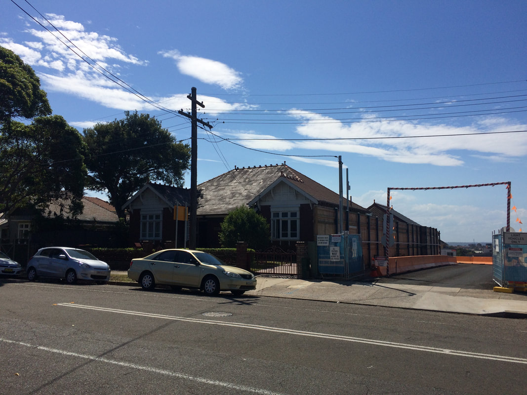
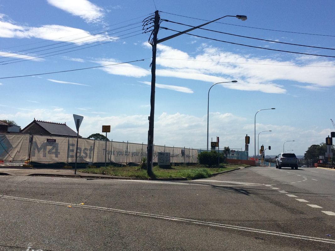
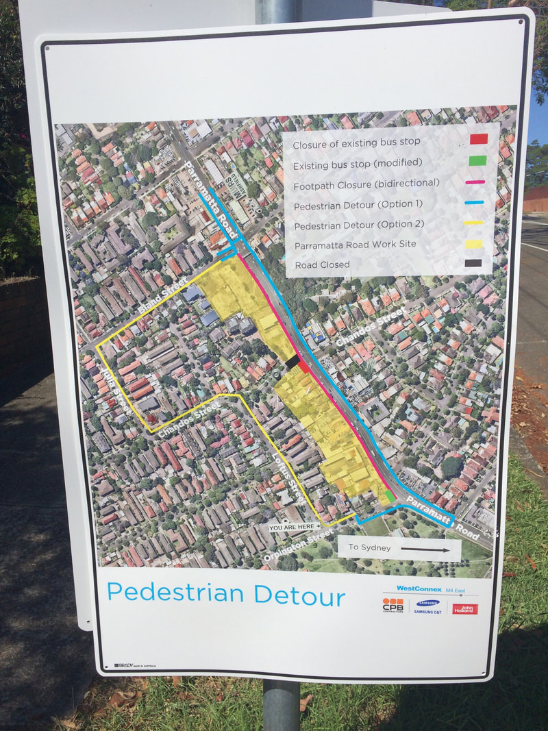
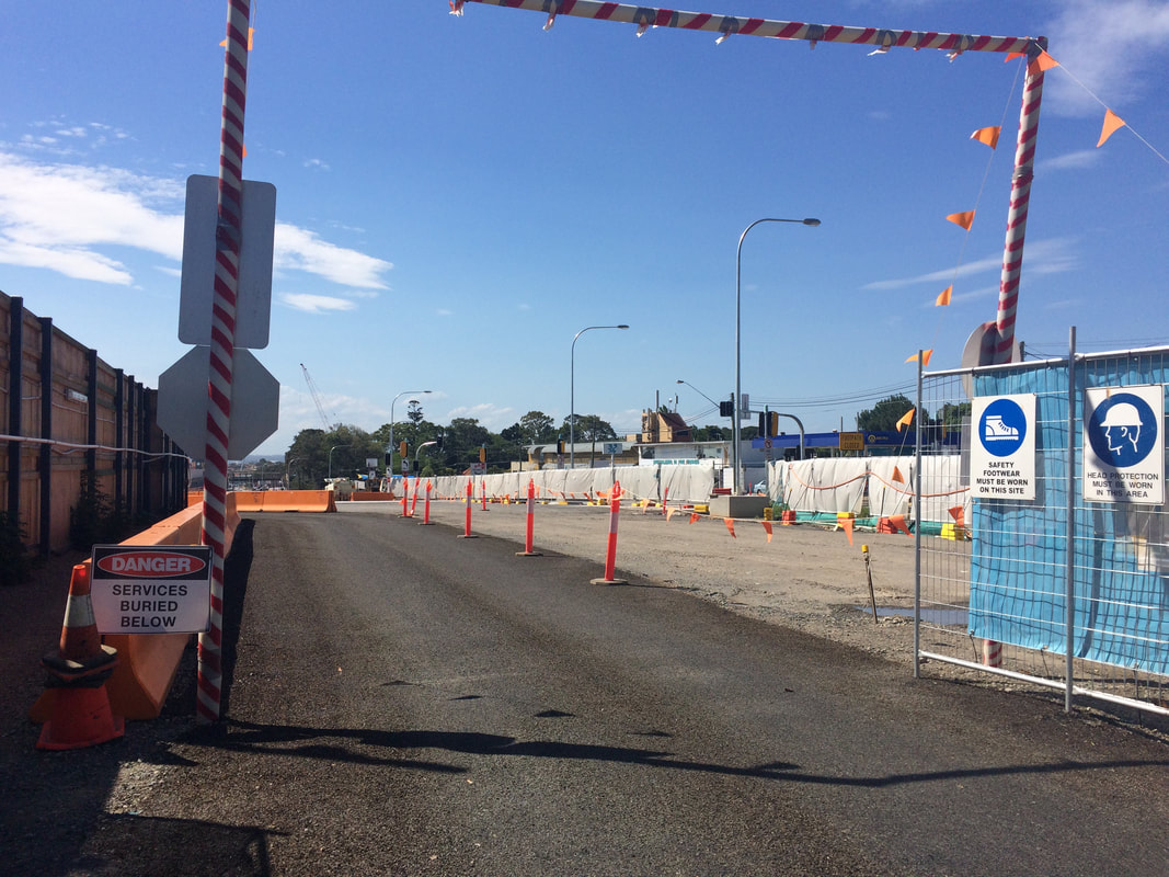
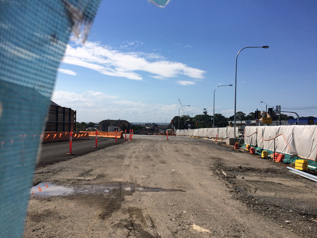
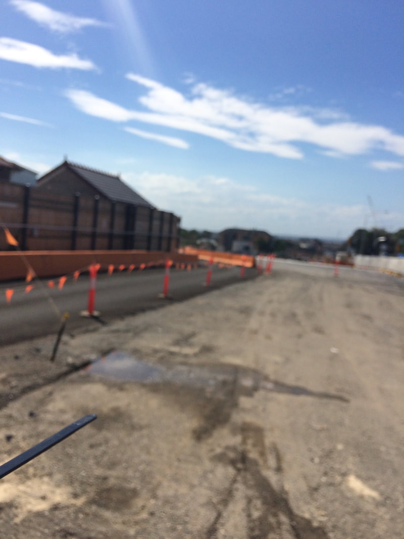
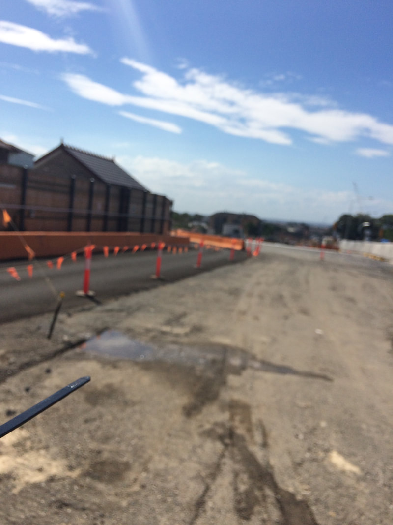
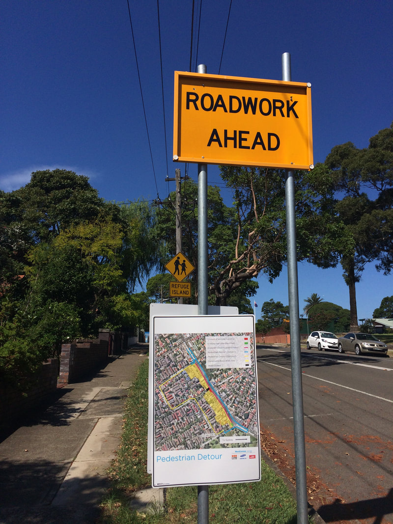
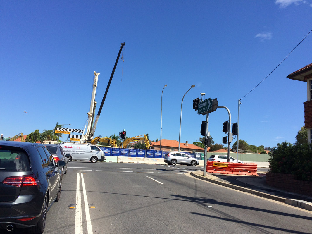
This is part of a unit of work for Changing Places - Australia's Urban Future. Lesson 1: Australia's Projected Population Growth Lesson 2: Implications for Future Growth and Sustainability Lesson 3: Sydenham to Bankstown Urban Renewal Precinct Lesson 4: WestConnex - Sydney, Sustainability and Transport Lesson 4: Sydney Sustainability and Transport (Teacher's Notes) Lesson 5: The GreenWay Lesson 5: Deindustrialisation Lesson 6: Create an infographic Lesson 7: Contributing to a Sustainable Urban Future Lesson 7: WestConnex - Protest Movements and Impacts Lesson 7: Conflict Over Dulwich Hill OR See the complete unit on the Changing Places website. Background: WestConnex overview M4-M5 Link Concept Design To bring Sydney together, WestConnex tears suburbs apart The development and construction of WestConnex has impacted and changed places. Large sections in the vicinity of Parramatta Rd in Ashfield and Concord and the western part of the suburb of Haberfield have been demolished to make way for the road development. You can read more about this here - West Connex's collision course into communities or in my previous posts. Impact at St Peters, Alexandria and Newtown Stage 2 of the WestConnex project involves the construction of a tunnel between St Peters and Kingsgrove. The King Street Gateway and the Campbell Road Green link are changing the nature of St Peters, Alexandria and Newtown. View the St Peters Overview. Links: Changes to St Peters can be seen in the link below. Sydney's WestConnex changes the face of St Peters - in pictures Information about the construction at St Peters can be found in the following article: WestConnex inflicts non-stop construction on St Peters for the next 3 weekends. 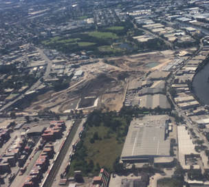 The M4-M5 link tunnels will run underneath Newtown. Many Newtown business owners have begun protesting the development, worried that congestion and bottlenecks will negatively impact retail businesses, or alternatively that clearways along King St will kill business. The Newtown WestConnex Action Group has been formed. In Alexandria a new bridge is being constructed over the canal to allow movement of traffic from the St Peters interchange.
Links: Six tunnels will be built under Andre's house in Lorde St Newtown. "Write an email": Sydney residents get no more answers as WestConnex hits Alexandria. Official: WestConnex allowed to flout environmental laws.
1 Comment
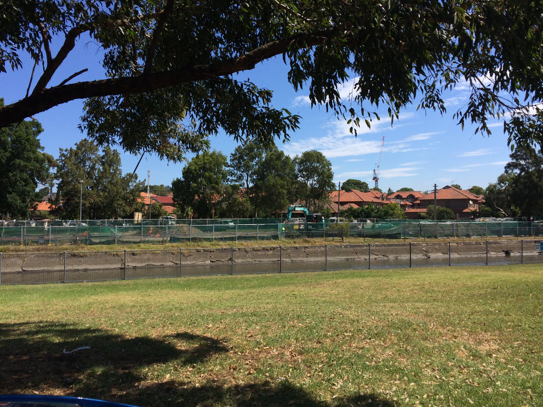
This is part of a unit of work for Changing Places - Australia's Urban Future. Lesson 1: Australia's Projected Population Growth Lesson 2: Implications for Future Growth and Sustainability Lesson 3: Sydenham to Bankstown Urban Renewal Precinct Lesson 4: WestConnex - Sydney, Sustainability and Transport Lesson 4: Sydney Sustainability and Transport (Teacher's Notes) Lesson 5: The GreenWay Lesson 5: Deindustrialisation Lesson 6: Create an infographic Lesson 7: Contributing to a Sustainable Urban Future Lesson 7: WestConnex - Protest Movements and Impacts Lesson 7: Conflict Over Dulwich Hill OR See the complete unit on the Changing Places website. Dulwich Hill is a suburb located in Sydney's Inner West, surrounded by Summer Hill, Hurlstone Park, Marrickville, Petersham, Lewisham and Earlwood. It experienced growth in the late 1800s following the introduction of the tram line, and as a result contains buildings with heritage architecture, particularly Federation architecture. The tram line through Dulwich Hill was not in use as public transport from the 1950s. The Inner West light rail extension in 2013 reconnected Dulwich Hill by rail with nearby suburbs and the city. For more details see my previous post Inner West Light Rail Extension. For more information about the history and development of Dulwich Hill, visit the Dulwich Hill section of the Marrickville historical society - Dulwich Hill - a history. The Sydenham to Bankstown Urban Renewal Strategy, encompasses the suburb of Dulwich Hill, rezoning for higher density and redevelopment of older buildings. Changes to zoning as part of this strategy can be seen on the Planning NSW website - Dulwich Hill Landuse Plan. The plan for Dulwich Hill includes 2000 more dwellings, with 3 storey development along Wardell Road, and unit developments from 3-5 storeys near the Dulwich Hill station. Higher density housing developments are zoned for around the Dulwich Hill light rail station (between 3-7 storeys). 8 storey developments will be allowed around Arlington Grove Light Rail station. View the Changing Places - Sydenham to Bankstown Urban Renewal Precinct post. The Save Dulwich Hill Community Group promotes issues related to the redevelopment of the suburbs and lobbies the government to preserve the heritage of suburb. Visit the Save Dully website to read more about their actions. This is part of a unit of work for Changing Places - Australia's Urban Future. Lesson 1: Australia's Projected Population Growth Lesson 2: Implications for Future Growth and Sustainability Lesson 3: Sydenham to Bankstown Urban Renewal Precinct Lesson 4: WestConnex - Sydney, Sustainability and Transport Lesson 4: Sydney Sustainability and Transport (Teacher's Notes) Lesson 5: The GreenWay Lesson 5: Deindustrialisation Lesson 6: Create an infographic Lesson 7: Contributing to a Sustainable Urban Future Lesson 7: WestConnex - Protest Movements and Impacts Lesson 7: Conflict Over Dulwich Hill OR See the complete unit on the Changing Places website. Stage 1 of the WestConnex project involves the widening of the M4, a connection between Parramatta Road and the City West Link and new connections at Concord Road. A tunnel will run from the end of the current M4 to the City West Link, M4 East concept design WestConnex Stage 1 WestConnex interactive map Ashfield A section of Ashfield along Parramatta Road was acquired and demolished for WestConnex. The exit to the M4 tunnel will be opposite Bunnings Warehouse near the crossroads of Frederick St/ City West Link and Parramatta Road. Link: WestConnex plan jeered by Ashfield residents Save Ashfield Park Rally Haberfield Some of the issues raised in relation to WestConnex in Haberfield include home acquisitions, destruction of heritage architecture, noise and vibrations for homes adjacent to construction sites, changes to traffic flows and the impact of all of these factors on the nature of the suburb. Links: Haberfield homes acquired for building of WestConnex Three month closure of Ramsay Street Haberfield Talking WestConnex and Mike Baird ignoring compulsory aquisition reforms WestConnex private contractors sell items from heritage homes ahead of demolition WestConnex unused land should be handed back say inner west residents. Residents in Haberfield and Beverley Hills claim WestConnex work is cracking walls of houses near motorway construction sites. What we are facing is the destruction of Haberfield
Guest blogger: Bruce BarclayThe recently released stage six draft modern history syllabus fails to clearly articulate a vision for the study of modern history in a globalised world. In its previous incarnation, the stage six syllabus at least paid lip service to areas of modern history which were not European in nature, i.e. India as one option. This final draft does not reflect the four options which were tabled to teachers who took the time to provide feedback to BOSTES previously. Teachers of this subject have been ignored with the release of the final draft.
The National Study and Peace and Conflict topic areas have been left relatively unscathed. However the inclusion of Iran into the national study topic area replaces India which is a lost opportunity. Similarly, the Peace and Conflict topic retains the main options, with the inclusion of Conflict in the Gulf 1991-2011, which replaces the UN as Peacekeeper. Essentially these two areas of study have escaped political influence. One of the real, if not the most problematic areas, is the core topic. Instead of utilising one of the options tabled at the consultation process, BOSTES has obviously bowed to political pressure and ignored the recommendations of the majority of teachers. World War One was a topic which although staid, at least had the advantage of being politically neutral and allowed teachers to engage in different national studies with no disadvantage to its students. For example a teacher of the USSR topic can build on students’ knowledge of the World War One topic. However as it stands, the core topic is Nazi Germany 1933-39 and teachers have to cover 9 detailed dot points taking up 60% of course time. To further compound the problem, teachers then need to teach another dictator, e.g. Pol Pot for 30% of the course. This begs the question: why is Nazi Germany deemed the most important topic for the core? Compounding the obvious bias, is that instead of removing Nazi Germany from the National Study it keeps Nazi Germany, but focuses on 1914-33. Clearly any teacher with half a brain will teach the German National Study first, then the Core/Nazi topic and if you haven’t got your fix of Nazi German history, you could finish with the European Conflict option for the Peace and Conflict topic. Already roughly 70% of the state teaches the Nazi option for the National Study so BOSTES wants the rest of the state to follow suit. As one person at the BOSTES consultation meeting at Hurstville remarked “That’s the end of the Soviet Union in every sense”. The USSR and for that matter the other options have been "relegated to the dustbin of history," to quote Goebbels, I mean Trotsky. It’s already working! Unlike the Ancient History course, BOSTES have removed the Personality topic from Modern History and replaced it with Change in The Modern World. I actually thought there has been a lot of change in the modern world in the twentieth century - that is why students love studying Modern History. BOSTES wants teachers to not only teach a personality, e.g. Gorbachev but link it to a time frame of nearly 70 years - The Changing World Order 1945-2011. This option has 19 dot points to cover, plus an evaluation of Gorbachev during the Cold War period. Furthermore, as a hat tip to the old UN as Peacekeeper topic, teachers have to assess the role and impact of the UN as international peacekeeper in relation to one trouble spot in the world, e.g. Somalia. Evidently the old inconsistencies of comparability between the ancient and modern course remain but are amplified, further alienating modern history teachers. If I was a student and had equal interest in modern and ancient history I would choose ancient for ease of content and variety. I hope that someone more technically adept than myself will be able to create a parody of the modern syllabus using snippets from The Downfall movie on youtube. I won’t even start on the exam specifications. This is a study planner for 2 unit Studies of Religion. You will need to download the file and customise it for your individual depth studies, significant person or school of thought, ethical issue and significant practice. It would also be useful to specify the religious traditions you have used in the Religion and Peace topic, so that there is no confusion for students. Perhaps give students a list of practice essays with this document so that they can choose some to complete as they work through each topic. If you like this planner, you may like to see the other planners for: Ancient History Legal Studies Geography; and Business Studies. 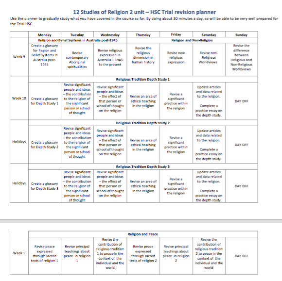 Download the file to modify it with your own depth studies.
Following the responses from similar, previous posts for Geography and Legal Studies, I have created a revision schedule for students in the lead up to HSC Trials for Ancient History. You will obviously need to modify it based on your options, but you can at least use it as a scaffold. Have a look at the previous posts regarding the study planner based on other subjects for more details. 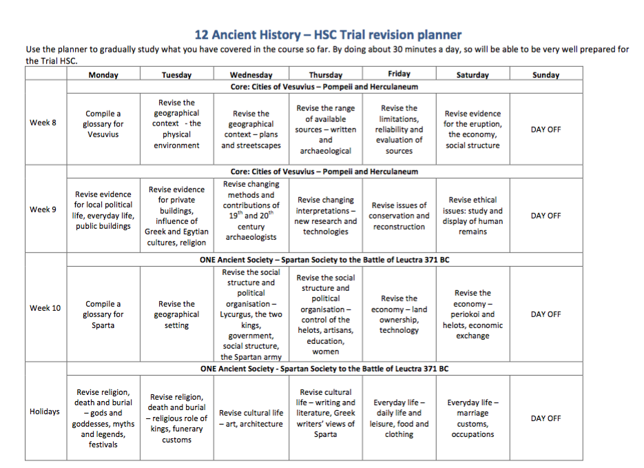 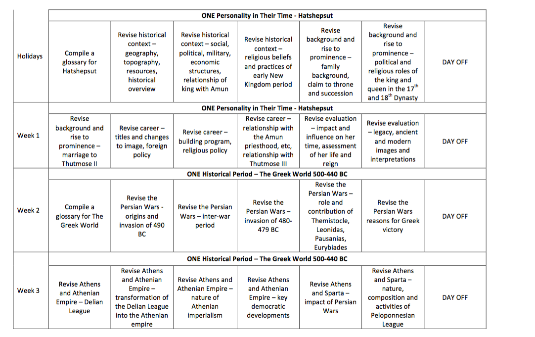
Following on from the Legal Studies revision planner is a Geography planner to guide student revision. For my class, I allocated Ecosystems At Risk and Urban Places two weeks each and only gave People and Economic Activity 1 week – this was because my class won't have done the the PEE case study by the time of the Trials. In this planner I have allocated 2 weeks revision for each topic and a week for skills revision. Depending on your students it is also a really good time to emphasise with students the importance of getting the balance right between study, their part-time job, socialising, eating right and exercising. If they can set up the right routines now, they will find it easier to cope when the Trials and HSC exams are on. 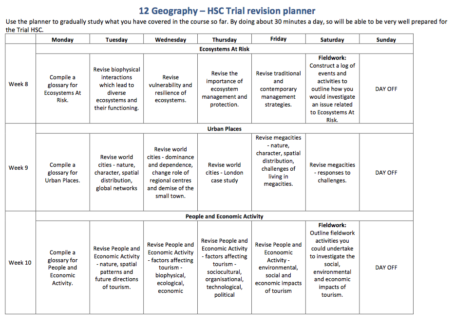 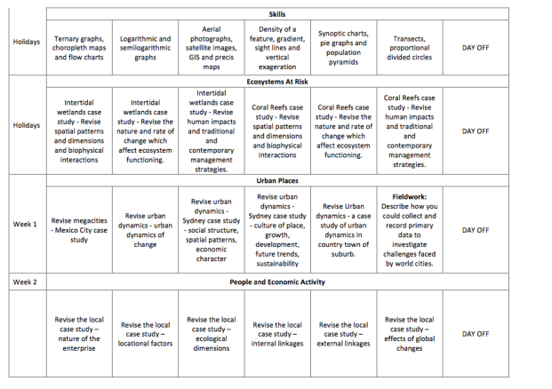
Your task is to create a presentation for your class which explains how one land use (residential, commercial or industrial) has changed over time. You must discuss each of the following: economic character, nature and location. Your presentation must include:
- statistics which support your key points - at least two maps (to show change over time) - an article which supports what you are stating You must prepare and distribute a two page handout. Your presentation should go for 8-10 minutes and should include a range of simulus (visual aids, etc). Articles: Paying huge Sydney prices for tiny places. Read more... 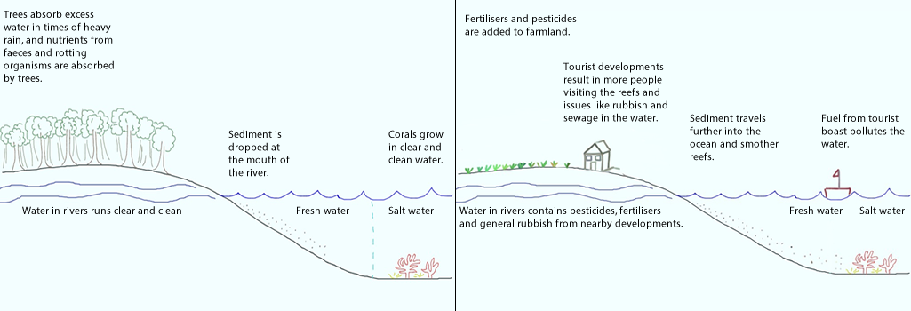 Population pressure
Increased population pressures on mainland North Queensland have resulted in increased levels of pollution and physical activities related to tourism on the reef area. Tourism The outstanding beauty of the reef attracts millions of tourists each year. The pressure placed on the reef as a result of tourism includes developments on the shoreline (and associated sewage, rubbish) increase boating activity (including oil spills, coral breakage as a result of boat propellers), and tourist activities (breaking corals while snorkelling, walking on reefs, accessing sensitive areas). Agriculture (particularly Sugar cane farming) Agriculture, especially sugar cane farming on the mainland, has resulted in increased sediment and fertiliser run-off from cane farms. In recent years, a downturn in global prices for sugar cane has resulted in farmers using greater amounts of chemicals. These chemicals run off into coastal streams and result in algal blooms and eutrophication in some areas of fringing coral near the mainland. Sugar cane farmers apply fertilisers containing Nitrogen (N) and Phosphorous (P). Many put on extra fertiliser in case of heavy rain (so it is not all washed away). The introduction of bananas as a crop in the area further increased the use of fertilisers. Of all fertilisers applied, only a third is absorbed by the crops. The rest is either evaporated, enters groundwater or runs off into nearby rivers or canals. Sugar cane crops need water to be drained away quickly. If the crops are left in water the roots will rot. As a result canals were built to drain water away quickly from the crops in case of heavy rain. These canals, or drains, reverse the cycle of how wetlands are meant to function. Rather than regulate and slow the flow of water, the water is quickly moved away from the site and into main river systems. The water rushes off the land carry fertiliser, soil, pesticides, etc. Actually pinpointing the sources of sediment is difficult, but it is believed that most is coming from land which has been tilled and let lie fallow. Sediment is also coming from bank erosion. Since European settlement erosion has accelerated due to clearing of land (less tree to stabilise soil). Due to erosion the river can erode into paddocks. There is believed to be four times more sediment reaching the coast than prior to European settlement, and in some places it is closer to 40 times. Fishing Recreational and commercial fishing have had major impacts on the reef. Commercial prawn fishing accounts of a large proportion of Queensland's Fisheries output. Approximately 6 million kgs of prawns area harvested in a good year. Recreational fishing in the General Use zones of the Great Barrier Reef Marine Park (GBRMP) accounts for 75% of the fin fish taken from the reef each year. Commercial fishing includes fishing for crayfish, finfish, reef fish, barramundi and tuna. An examination of one net which washed ashore showed it contained 14 turtles, a shark and a dugong. Gamefishing has long been an important industry in North Queensland. Pisciculture is a trend involving raising fish in fish farms (e.g. tiger prawns and barrmundi). Dredging Dredging is removing sediment from the bottom of a river bed, harbour, etc and placing it elsewhere. Links: Abbot Point: Dredging dumping permitted within Great Barrier Reef waters Abbot Point approval: Tour operators disappointed by Great Barrier Reef dredge spoil decision Approval of Galilee mega mine leaves Reef strategy in tatters. Landuse impacts on Great Barrier Reef water quality and ecosystem condition Dredging set to swamp decades of Great Barrier Reef protection WWF - Queensland resources sector needs leadership If you are planning an excursion to the Great Barrier Reef you have a couple of options - base yourself at Cairns or Port Douglas and travel out to the reef and surrounds, or base yourself out on one of the islands. Your decision will be determined by cost, availability and also whether you are just focusing on coral reefs on your trip or a rainforest or wetland ecosystem as well. You might like to look into one of the research stations which are located nearby. Heron Island Research Station and Moreton Bay Research Station are run by The University of Queensland. These venues offer excellent facilities such as lecture theatres, computer rooms, laboratories, diving and snorkelling equipment, bunk room accommodation, the option of on-site catering. Lizard Island Research Station is run by the Australian Museum. The station offers accommodation, boats, laboratories, aquarium systems, diving and more. If you are based at Cairns or Port Douglas then you will probably use the tour operators operating such as Quicksilver or Sunlover Reef Cruises, where you can get a Guided Snorkelling Safari Tour where students learn about the basics of coral and fish identification, reef ecology and marine conservation. Small World Journeys offer a Student Trip: Ecosystems at Risk: Reefs and Rainforest, 6 day trip. This includes all accommodation, most meals and trips. There is also a 4 day Ecosystem at Risk: Coral Reefs Study available. |
|||||||||||||