|
There is a huge amount of information available about coral reef health and in particular the mass coral bleaching events that have occurred over the past two years. Two of my previous posts are linked below, but if you scroll to the bottom of the page there are a range of other articles, reports and websites regarding coral bleaching that you might find useful.
Previous posts: Mass coral bleaching events Coral bleaching - reef resilience Students should define the following key terms: - acclimatise - connectivity - recruit - adaptation - natural selection - symbiotic - zoozanthallae - parasite - photosynthesis Answer the questions below. Conduct internet research to find articles and reports which support your answers.
Resources: Coral bleaching - GBRMPA Coral bleaching and the Great Barrier Reef - ARC CoE Coral bleaching: Extreme heat pushes parts of the Great Barrier Reef beyond recovery - ABC Coral bleaching events - AIMS Great Barrier Reef: a "hopping hotspot" - Australian Geographic
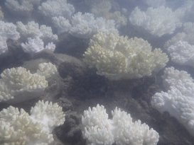
The changes in temperature and associated bleaching are resulting in a different mix of species on the reef. This will impact reefs in the long term. Loss of species Fish, whales, dolphins, sharks, rays and the many other organisms found in reefs rely on the complexity of the ecosystem for survival. Some fish rely on the colour of the corals for camoflauge and the structure of the coral for hiding. Many organisms are unable to carry out normal functions and processes as a result of the increased ocean acidification associated with climate change. Shellfish are less able to create their shells due to increased pH. Slow growing corals will take 100-200 years to recover, meaning that the reef will not exist in the form that we have known it in the past. Dispersal of spawn Ocean warming impacts on the dispersal or coral spawn (eggs). Increased ocean temperatures result in a decline in the dispersal distance of coral spawn from the origin (parent coral) to the destination site. This change in dispersal patterns can impact on species' distribution, abundance or corals in particular areas and genetic diversity across reefs. Changes to dispersal patterns can also impact on the connectivity (interconnections) between different areas of the reef by limiting the areas of reef that particular coral species are located. Poleward shift of species Ocean warming can also result in a poleward shift of species from tropical zones to more temperate zones. Warmer waters are found further from the tropics and species are able to take advantage by increasing their range. In Western Australia, a species of wrasse - cheorodon rebuscens has started to shift its range with displacement of recruits south of its usual habitat. There is evidence of high recruitment at the temperate edge and no recruitment at the tropical edge. The range shift provides limited expansion opportunities, reducing resilience of the species. Irukandji are migrating further south on the Great Barrier Reef as a result of warmer waters and are also having longer seasons in other areas. There have been anecdotal reports of increases in reports of stinging and hospitalisations on islands within the Great Barrier Reef (e.g Fitzroy Island) and snorkellers are being strongly advised to wear stinger suits outside of usual peak Irukandji seasons. Irukandji and associated stingings have also been reported on western side of the southern tip of Frazer Island where they haven't previously been found. Symbiotic relationships Following bleaching events or even natural disasters, corals can become overgrown with algae, making it difficult for coral recruits to settle and grow. The mix species on a reef can impact on how resilient that particular reefs is. For example in Moorea in French Polynesia experienced high coral mortality in the 1980s. Recovery of the reef was enabled in part as a result of grazing fish such as parrot fish removing some of the algae in the process of eating corals. In this way the biodiversity of the reef contributed to high levels of resilience on the reef in comparison to some other reefs globally. The scale of the bleaching on GBR make it unlikely that these types of natural processes will have much of an impact on recovery. Below: A parrot fish on the outer reef, 2015.   I had the pleasure of hearing Professor Terry Hughes present as part of the Sydney Ideas talks being run by the University of Sydney. Professor Hughes is Centre Director at the ARC Centre for Excellence for Coral Reef Studies at James Cook University. I use the term "pleasure" because I am a big fan of his work, and think that some of the visual representations that he has created have been incredibly powerful in explaining coral bleaching to students, but actually the information presented was really quite depressing. Image left: Photograph of bleached corals at Fitzroy Island April 2017. Hughes described some of the main drivers of degradation of coral reefs: pollution, overfishing and climate change. He explained how overfishing had resulted in the reduction of stock sizes for different species in the past century, how pollution from inland activities resulted in coral mortalities and encroachment of different ecosystems like mudflats in areas previously thriving with corals. He went on to say that the scale and extent of these changes were being dwarfed by the immediate and irreparable changes being wrought by back to back bleaching events. Below right: Bleached coral on Fitzroy Island April 2017.
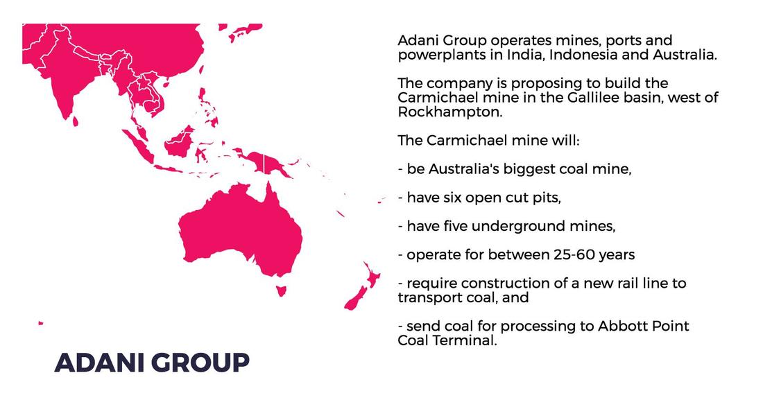
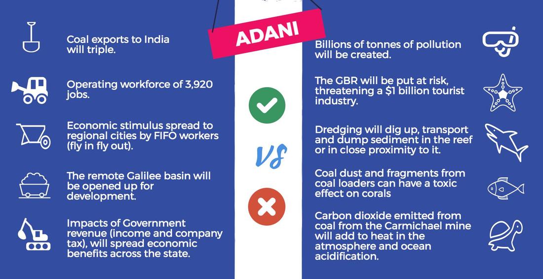
Mass bleaching events have occurred in both 2016 and 2017 as a result of increased ocean temperatures. The bleaching is as a result of corals expelling their symbiotic algae. Coral bleaching tends to occur after the summer temperature maximum, and relates to where the hottest water is. In 2016 coral bleaching severely bleached the northern third of the Great Barrier Reef, the middle section was bleached to a lesser extent, but still quite severely, while the bottom third of the reef largely escaped bleaching in 2016. This was established by the surveying of 1160 reefs through 9000km of aerial surveys, and 75 hours of flying. The 2017 bleaching event impacted the central section of the GBR, while the bottom third is again largely unbleached. Cycle Debbie, a chance weather event, lowered temperatures in the southern part of the reef, which contributed to reducing bleaching in this section. The combination of both the 2016 and 2017 bleaching events has been extremely damaging. There have been reports that the recent cyclone that affected Queensland, Cyclone Debbie may play a role in reducing the impact of coral bleaching. It was reported in the Cairns Post that the cyclone would reduce ocean temperatures, bring cooler waters to the surface and increase cloud cover, thus reducing bleaching, providing stressed corals with an opportunity to recover. The Cairns Post reported that temperatures off Lizard Island had dropped by three degrees and that this would reduce the severity of bleaching. It also provided quotes from a free diver describing the amazing colours and marine life of the outer reef. In reality, as already stated Lizard Island and the top third of the Great Barrier Reef were already severely affected by bleaching in 2016 (well before Cyclone Debbie) and were again affected in 2017. In any case, the path of the cyclone was too far south to have any real impact on areas severely affected by bleaching. Will the Great Barrier Reef recover? There is a narrow opportunity for limited recovery, but the Great Barrier Reef as we know it (complexity, extent, etc) is already dead in many areas. It will continue to exist but with reduced biodiversity. Any real opportunities to protect the reef as it remains is reliant on halting temperature increases and stabilising the climate through reducing reliance on fossil fuels. With negotiations underway between the Australian Government and Adani for for the creation of the Marmichael mines this seems highly unlikely. For more detail on coral bleaching see my article in this term's GTA NSW HSC edition of the Bulletin. http://www.gtansw.org.au Symbiotic relationships Symbiosis is a long term relationship between two organisms. There are three types of symbiotic relationship: mutualism (where both organisms benefit), commensalism (where one species benefits, but there is no benefit or harm to the other species), and parasitism (where one organism benefits tot he detriment of the other). There are many examples of symbiosis on coral reefs. Corals and zooxanthallae The relationship between the corals and the zooxanthallae is beneficial to both. Corals provide the zooxanthallae with an environment suitable for survival. It is moist and the coral's waste gives energy to the zooxanthallae. Through the process of photosynthesis the zooxanthallae produce compounds that the coral use for food. Clownfish and Sea Anemones The Sea Anemones have tentacles with stinging cells. These stinging cells kill many organisms and it is in this way the anemones get their food. Clownfish hide in amongst the tentacles of the Sea Anemone, but are not harmed by them. In this way the clownfish are protected from other predators. Occasionally the Clownfish will catch food for the Sea Anemone. Sharks and Remoras Sharks sometimes get parasites which live on the external surface of the shark. Remoras are cleaner fish, and they attach themselves to the shark and kill the parasites. When the shark feeds the Remora are able to eat the scraps from the feed. Watch the videos below, and take notes about the following symbiotic relationships: - Christmas tree worms and porites corals - Coral shrimps and corals - Goby shrimp and Hawaiian Shrimp Goby - Cleaner Wrasse and cleaning stations Following on from the Legal Studies revision planner is a Geography planner to guide student revision. For my class, I allocated Ecosystems At Risk and Urban Places two weeks each and only gave People and Economic Activity 1 week – this was because my class won't have done the the PEE case study by the time of the Trials. In this planner I have allocated 2 weeks revision for each topic and a week for skills revision. Depending on your students it is also a really good time to emphasise with students the importance of getting the balance right between study, their part-time job, socialising, eating right and exercising. If they can set up the right routines now, they will find it easier to cope when the Trials and HSC exams are on. 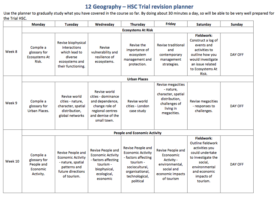 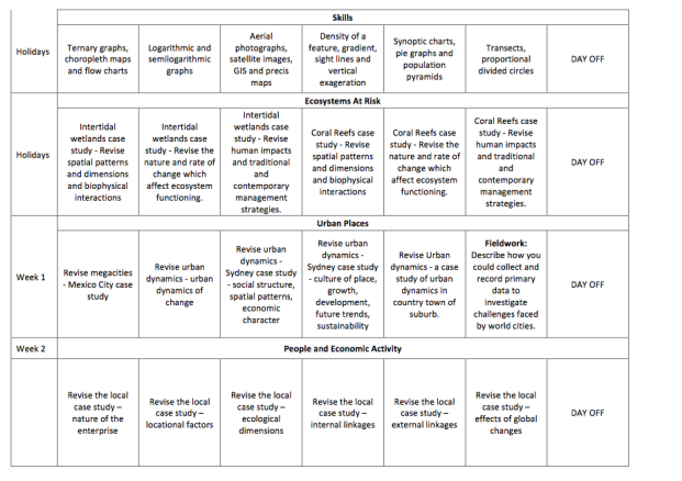
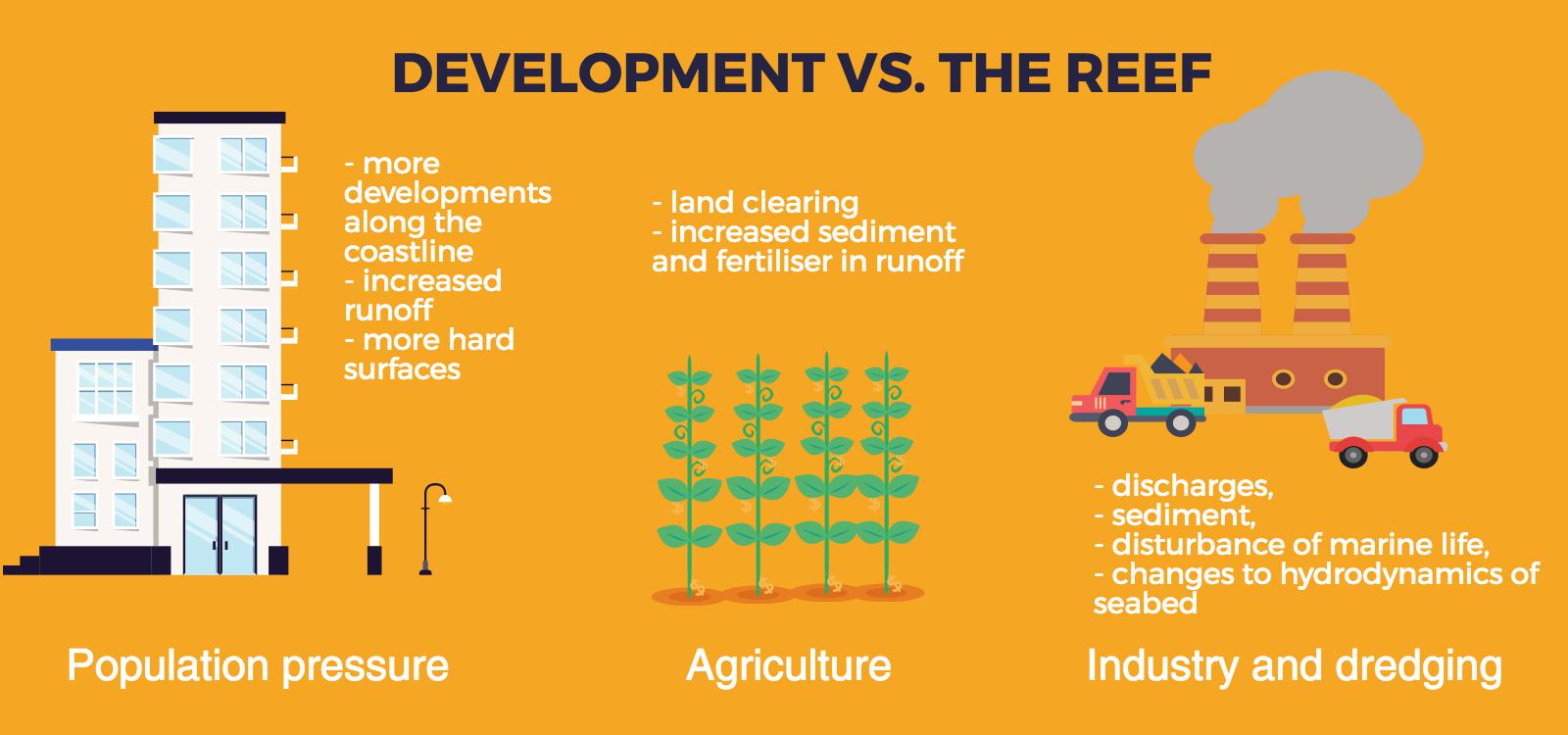
  Population pressure
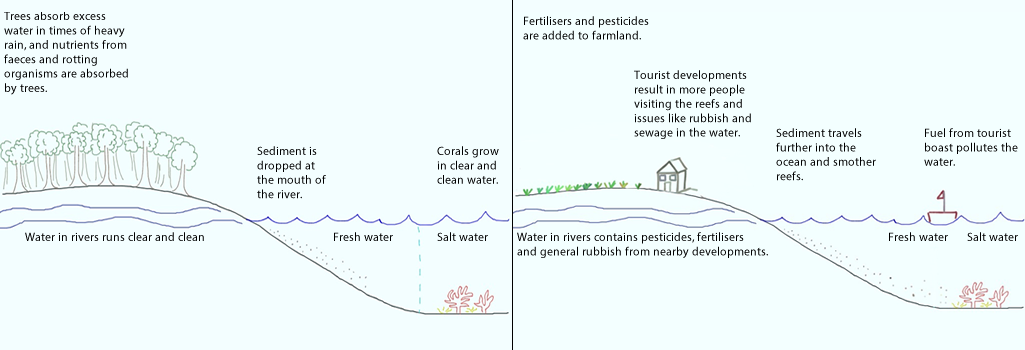
Increased population pressures on mainland North Queensland have resulted in increased levels of pollution and physical activities related to tourism on the reef area. Tourism The outstanding beauty of the reef attracts millions of tourists each year. The pressure placed on the reef as a result of tourism includes developments on the shoreline (and associated sewage, rubbish) increase boating activity (including oil spills, coral breakage as a result of boat propellers), and tourist activities (breaking corals while snorkelling, walking on reefs, accessing sensitive areas). Agriculture (particularly Sugar cane farming) Agriculture, especially sugar cane farming on the mainland, has resulted in increased sediment and fertiliser run-off from cane farms. In recent years, a downturn in global prices for sugar cane has resulted in farmers using greater amounts of chemicals. These chemicals run off into coastal streams and result in algal blooms and eutrophication in some areas of fringing coral near the mainland. Sugar cane farmers apply fertilisers containing Nitrogen (N) and Phosphorous (P). Many put on extra fertiliser in case of heavy rain (so it is not all washed away). The introduction of bananas as a crop in the area further increased the use of fertilisers. Of all fertilisers applied, only a third is absorbed by the crops. The rest is either evaporated, enters groundwater or runs off into nearby rivers or canals. Sugar cane crops need water to be drained away quickly. If the crops are left in water the roots will rot. As a result canals were built to drain water away quickly from the crops in case of heavy rain. These canals, or drains, reverse the cycle of how wetlands are meant to function. Rather than regulate and slow the flow of water, the water is quickly moved away from the site and into main river systems. The water rushes off the land carry fertiliser, soil, pesticides, etc. Actually pinpointing the sources of sediment is difficult, but it is believed that most is coming from land which has been tilled and let lie fallow. Sediment is also coming from bank erosion. Since European settlement erosion has accelerated due to clearing of land (less tree to stabilise soil). Due to erosion the river can erode into paddocks. There is believed to be four times more sediment reaching the coast than prior to European settlement, and in some places it is closer to 40 times. Fishing Recreational and commercial fishing have had major impacts on the reef. Commercial prawn fishing accounts of a large proportion of Queensland's Fisheries output. Approximately 6 million kgs of prawns area harvested in a good year. Recreational fishing in the General Use zones of the Great Barrier Reef Marine Park (GBRMP) accounts for 75% of the fin fish taken from the reef each year. Commercial fishing includes fishing for crayfish, finfish, reef fish, barramundi and tuna. An examination of one net which washed ashore showed it contained 14 turtles, a shark and a dugong. Gamefishing has long been an important industry in North Queensland. Pisciculture is a trend involving raising fish in fish farms (e.g. tiger prawns and barrmundi). Dredging Dredging is removing sediment from the bottom of a river bed, harbour, etc and placing it elsewhere. Links: Abbot Point: Dredging dumping permitted within Great Barrier Reef waters Abbot Point approval: Tour operators disappointed by Great Barrier Reef dredge spoil decision Approval of Galilee mega mine leaves Reef strategy in tatters. Landuse impacts on Great Barrier Reef water quality and ecosystem condition Dredging set to swamp decades of Great Barrier Reef protection WWF - Queensland resources sector needs leadership If you are planning an excursion to the Great Barrier Reef you have a couple of options - base yourself at Cairns or Port Douglas and travel out to the reef and surrounds, or base yourself out on one of the islands. Your decision will be determined by cost, availability and also whether you are just focusing on coral reefs on your trip or a rainforest or wetland ecosystem as well. You might like to look into one of the research stations which are located nearby. Heron Island Research Station and Moreton Bay Research Station are run by The University of Queensland. These venues offer excellent facilities such as lecture theatres, computer rooms, laboratories, diving and snorkelling equipment, bunk room accommodation, the option of on-site catering. Lizard Island Research Station is run by the Australian Museum. The station offers accommodation, boats, laboratories, aquarium systems, diving and more. If you are based at Cairns or Port Douglas then you will probably use the tour operators operating such as Quicksilver or Sunlover Reef Cruises, where you can get a Guided Snorkelling Safari Tour where students learn about the basics of coral and fish identification, reef ecology and marine conservation. Small World Journeys offer a Student Trip: Ecosystems at Risk: Reefs and Rainforest, 6 day trip. This includes all accommodation, most meals and trips. There is also a 4 day Ecosystem at Risk: Coral Reefs Study available. Management of the Coral Triangle Government Collaboration The six nations of the Coral Triangle came together in 2009 to form the Coral Triangle Initiative on Coral Reefs, Fisheries and Food Security. The countries use national coordinating committees, learning networks, regional exchanges, capacity building workshops to come together to share their knowledge and expertise. The Coral Triangle Support Partnership (CTSP) is an initiative run in collaboration with WWF, The Nature Conservancy, Conservation International and USAid, among other groups. It is a 5 year, $32 million program designed to support the governments of Indonesia, Malaysia, Papua New Guinea, Philippines,mSolomon Islands and Timor-Leste. The initiative is aimed at addressing over-fishing, destructive fishing practices, pollution and climate change. CTSP assists in setting up and managing Marine Protected Areas, to conserve reefs and fish, protect shorelines, improve fisheries catches for locals, and enhance quality of life for communities. Each of the six nations has a National plan of Action which is aligned with the Regional Plan of Action set out by the CTI. Sustainable fishing Fishing practices are regulated, management practices align with stock distribution, spawning areas and migration routes are monitored and regulated. Malaysia - 5.5 million hectares of marine ecosystems under protection. - Training of wildlife wardens to manage coastal resources - Stopped issuing permits for export of endangered humphead wrasse, and buy back systems to buy out the species from fish farms. - Maliangian Handicraft Workshop - provide alternative lifestyle options to fishing. Papua New Guinea - Empower local communities and their traditional laws - Workshops, field trips, training - Locally Managed Marine Areas - Manus Environmental Communities Network - share best practice with communities - Milne Bay - fishermen trained and engaged in environmental monitoring, find raising and reporting. - Mahonia Na Dari Research and Conservation Centre - The Mahonia Na Dari Research and - Conservation Centre is a non-government organisation that develops marine environmental conservation education for children and local communities around Kimbe Bay, Papua New Guinea. Solomon Islands - Volunteer rangers in Western Provincetown monitor and tag turtle populations using their skills in water acrobatics and free diving. - Development of Best Practice Guidelines - Building the capacity of local groups such as the Gizo Marine Conservation Area Management Committee and the Tetepare Descendants Association - Tetepare Island - ecotourism, local rangers, gather data, patrol the island, monitor harvesting and confiscate illegal catches. Philippines - 20,000 hectares of Marine Protected Areas. - Government to map and plan ways to increase fish numbers for the future. - Mangrove planting projects Timor-Leste - Establishment of Niño Konis Santana National Park - Community awareness -workshops, film screenings, hands-on training, - Surveys of coastlines WWF Infographic - Marine protected areas in the Coral Triangle A map showing the Marine Protected Areas (MPAs), Coral Triangle boundaries, value of fisheries, subsidies paid to commercial fisheries, and funding required to support MPAs. See more... New hope for fisheries development in the Pacific. Financing marine protected areas. Coral Triangle Center Protecting marine turtles in the Indo-Pacific. Building a sustainable live reef food fish trade Promoting sustainable tuna fisheries in the Coral Triangle Tackling fisheries bycatch Effectiveness Malaysia - Traders continued to keep wrasse in "grow out" cages Papua New Guinea- difficult to coordinate as there are diverse systems of traditional law. Solomon Islands - geographical spread- managed by local communities. Lack of technical skills, scientific data, and resources such as equipment and fuel can hinder management. Complex clan structures and customary land ownership. Philippines - vulnerable communities Timor-Leste -limited information of reefs make it difficult for planning and decision-making. Something's fishy Legal and Policy gaps in the management of the live reef food fish trade in the Coral Triangle.
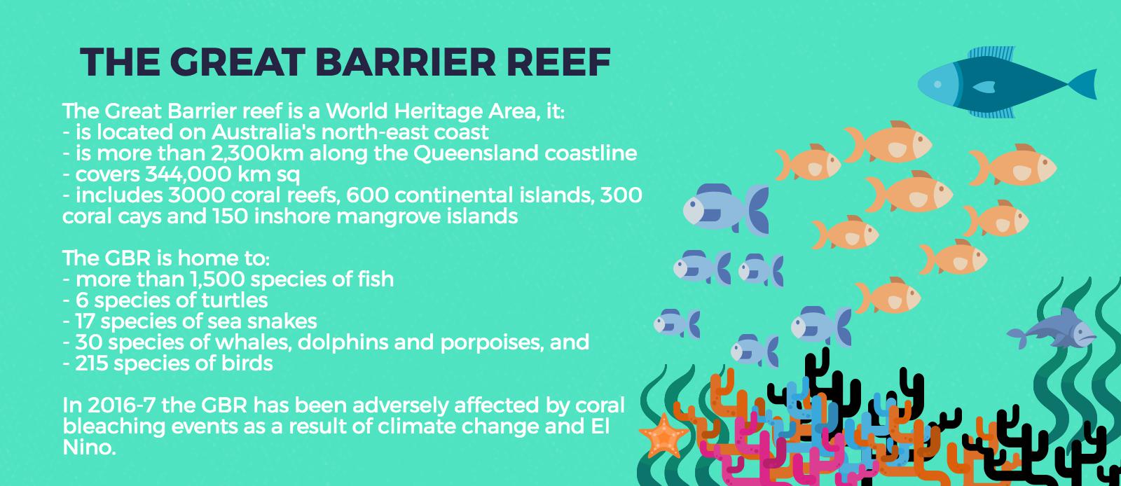
Location
Human impacts
Below is an infographic embedded that explores the destruction and overfishing of reefs of the Philippines 
From Visually. WWF has created an Infographic exploring seafood caught in the Coral Triangle. It incorporates a map showing the value of the tuna industry and live reef food fish industry, as well as levels of over fishing in the region. See the infographic... Links to explore human impacts on the Coral Triangle: Coastal development destroying reefs off Phuket An overview of shark utilisation in the Coral Triangle region. Problems in the Coral Triangle Climate change, reefs and the Coral Triangle |
|||||||||||