|
In Designing a Liveable City - Part 1, students designed a town In Designing a Liveable City - Part 2, students completed a self-assessment of their town. In Designing a Liveable City - Part 3, students gave and received peer feedback on their towns and responded to the feedback. In Designing a Liveable City - Part 4, students developed their towns working in a larger group, by applying the 5Cs of community building. When students arrive in the class all group tasks have been attached together to make one large city. Some additional land/building spaces has also been added (additional pieces of paper). Students are still responsible for their own area and ensuring the liveability of their residents, but they will now have a say in how the whole city develops. Students will be provided with a number of development proposals that will go before a combined council meeting involving the whole class. They are provided with 5 minutes in their original group to determine which of the developments they might like in/near their original development area. They will also need to assess how each of the developments will impact on liveability of residents.
Developments:
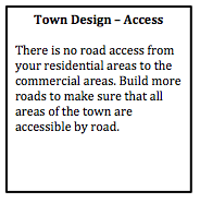
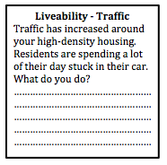
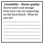
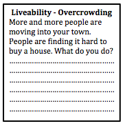
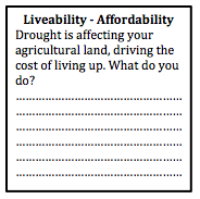
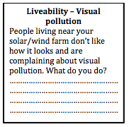
Highway A new highway has been built along the edge of the city. Parts of the city which are connected to the highway will have greater access to other parts of the city, other cities and regional areas. However, people around the area of the off-ramp will also be negatively affected by construction and possibly some demolition to make way for new roads. You will need to decide where the off-ramps for the highway will be located. You are allowed to have three off-ramps in total. (Off ramps - minimum 8 cm long) Resort Complex A large multination corporation wants to build a resort complex and marina. It will include several large hotels, a golf course, and specially designed harbour with moorings for yachts and pleasure craft (boats). It needs to be located on the coastline to take advantage of beach locations and provide an appropriate location for the marina. It also needs to be accessible by road. Choose an appropriate location. (Marina - 8cx8cm, resort complex 10cmx10cm). Recreational Complex The Federal government is going to provide substantial funding for a recreation and lifestyle complex and regional park. It will include a number of tennis courts, basketball/netball courts, soccer fields, football fields, as well as some open parkland with bike paths and foot paths. The complex will contribute positively to the quality of life of your residents. Choose an appropriate location. (Recreation complex 12 cmx12cm). National Park Lobbyists have proposed the creation of a national park. The park will protect environmental quality, provide opportunities for recreation (e.g. bushwalking, mountain climbing or snorkelling), and provide opportunities for tourism activities. Choose an appropriate location for the national park (12 cmx12cm). Technology hub A giant technology firm wants to set up a Tech Hub which will include a number of start-up businesses (new, small businesses) as well as several large technology businesses all in the one space. This will provide opportunities for employment in the city. (Tech Hub – 10cmx10cm) Assessing impact As individuals, students need to consider how each of these proposals will impact on liveability for residents, by determining the pros and cons of each proposal. Proposing a site In their original groups, students need to choose the proposal they are most interested in, propose an appropriate site and explain the impact on liveability. Council meeting As a whole class, the students will need to make decisions by consensus, debating and assessing the developments for Liveability. They will need to determine which developments will go ahead, and the best locations for each development proposal.
0 Comments
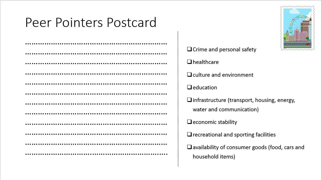
In Designing a Liveable City - Part 1, students designed a town In Designing a Liveable City - Part 2, students completed a self-assessment of their town. In Designing a Liveable City - Part 3, students gave and received peer feedback on their towns and responded to the feedback. When students arrive for this lesson, their towns have changed. The work of two groups has been joined together, so that two towns are now stuck together with some blank space in between. After working together with the one group for a while, at first students may be a little reluctant to work with others in a bigger group, but before long you will find that they will get on board knowing that they have more space to expand their town. Begin the lesson by revising content about Community and the characteristics that influence community identity. Discuss different suburbs or towns close to the school and how each of them have different identities and why. Discuss the culture of different places, and how the culture is expressed through public events and architecture. Revise the role of transport, technology, open spaces, meeting places and employment in building community. Read: The 5 "Cs" of community planning The students will be able to use the 5 "Cs" to guide the way they continue to develop their towns. Students move to their new, combined town and begin working with a larger group. They need to begin by explaining the different aspects of their initial town with the other half of the group and vice versa. Next they need to join the two towns together with roads and public transport and negotiate on how the land between the two towns will be used. Give them a set period of time (5-10 minutes depending on how much is left of the lesson) to work on each of the 5 'Cs'. At the end of the lesson they need to do a quick reassessment of the liveability of their new town based on the criteria provided in the previous lesson. 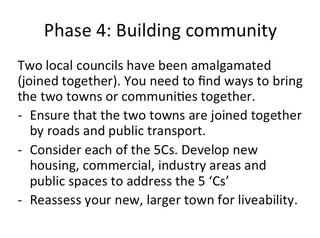 In Designing a Liveable City - Part 1, students designed a town. In Designing a Liveable City - Part 2, students completed a self-assessment of their town. Peer feedback provides an opportunity for students to assess liveability in a practical way, and also allows students to reflect on the feedback of others to make improvement in liveability. Hints on providing feedback. It is important to provide some guidance to students on how to provide effective feedback to their peers. If feedback is too harsh or personal it will not have the desired effect on progress. Provide the students with a brief criteria to base their judgements on, and go through the items listed to ensure the students know what all of the terms mean and the purpose of the task. In this case the criteria is a list of items that contribute to liveability. Students might just make simple suggestions such as "You need to build a high school" or "You need to build a hospital", but hopefully they will provide more detailed responses that indicate more knowledge of course content. In this lesson there were 6 groups of students, and each group rotated around to comment on the town plans of each other group. They were given "Peer Pointer Postcards" to write their comments on. They then returned to their own town map and had to reflect on the feedback given and consider changes to make to their plan. It is worth asking students to hand in their peer feedback to the teacher so you can check the comments that are made. This can then enable the teacher to ask the student to review any comments that are too personal or not detailed enough. Hints on receiving feedback Students who aren't used to peer feedback, may initially become defensive or upset about negative feedback. As the teacher it is important to prepare the students so they are ready and willing to accept ideas from others. A few tips for students:
 In Designing a Liveable City - Part 1, students designed a city. Once students have planned their city, they need to undertake a self assessment of their work. As a group they can sit and talk about the different aspects of their city and how they have addressed liveability. Provide them with a criteria to refer to. This might also be a good opportunity to provide students with a summary of the content that has been covered in class in relation to liveability, so that they can make connections between the activity they have been undertaking and course content.
The aim of this series of lessons is to allow students to apply their understanding of Liveability to a city design task. Students work in groups of 2-3 to design a small town, as the activity progresses they will reflect on what they have learnt in the Place and Liveability topic and apply it to their town. Phase 1: Design your town The first phase of this task involves designing the layout of the town. This will involve the initial road layout, agricultural land uses, some initial commercial land uses, power supply, and water storage. Provide some student choices so that you can provide a few variations in the first round of feedback. Provide students with a base page ( it may or may not have some geographical features on it such as mountains, coastline, rivers, etc). Also provide students with some blank, coloured pieces of paper, or you can copy the templates onto coloured paper - green (agricultural land), blue (water storage), pink (commercial), red (power supply), grey (roads). 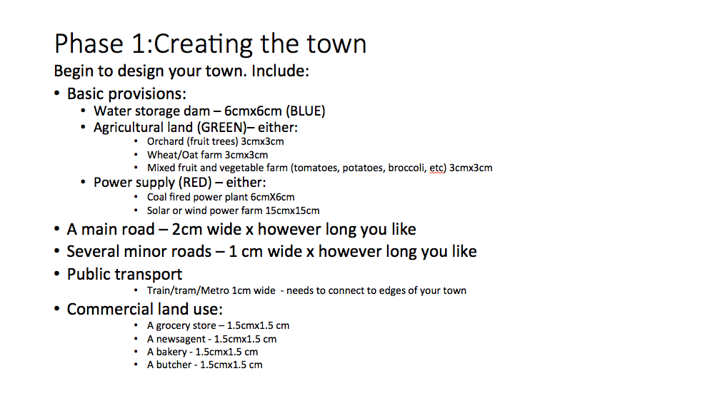
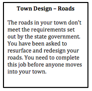
Design feedback This is an opportunity to provide some initial feedback to ensure the students get the basics right. Design the feedback so that it refers to the students as though they are members of the local council. For example, “The roads in your town don’t meet the requirements set out by the state government. You have been asked to resurface and redesign your roads. You need to complete this job before anyone moves into your town.”
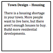
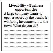
Phase 2: Moving in... In the second phase of the task, students design the residential layout and density of the town. By placing a relatively small limit on the number of dwellings students have to focus on the layout of the town in the initial phases. 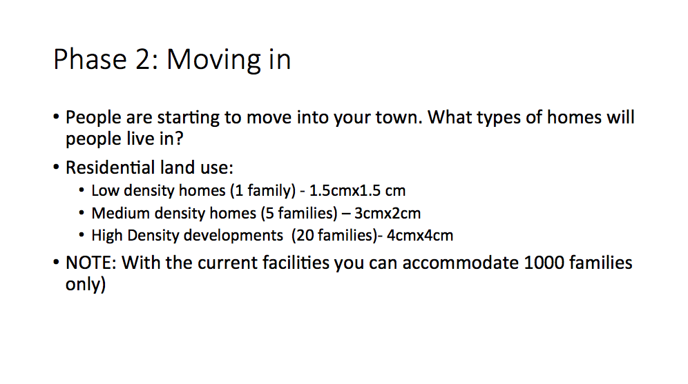
Town plan scenarios Provide students with some scenarios that will allow them to start to think about the liveability of their towns. By this stage some of the groups' conversations will have already addressed aspects of liveability, but they may not have actually considered in much depth. Students are required to write a brief description of how they addressed each scenario.
Phase 3: Enhancing liveability Students will need to respond to the scenarios above, and should have started to consider some of the additional needs of a community. As a class discuss the content related to liveability that you have already covered in class, and then provide students with time to make changes to their town plan. 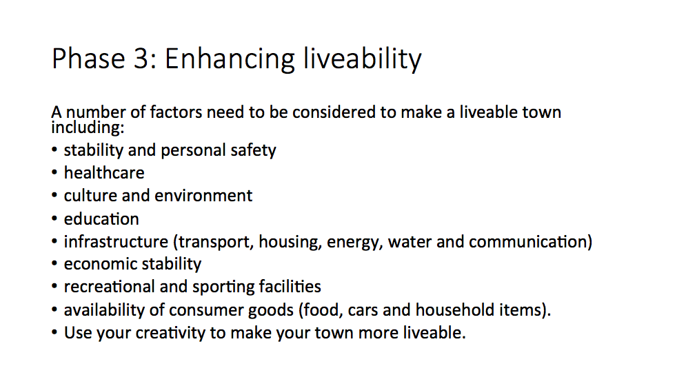 Phase 3: Liveability Students spend some time reviewing their towns and providing initiatives and strategies to make their town more liveable. They also need to address the scenarios provided by the teacher. Writing task Students need to write a description of how their town addresses different aspects of sustainability. Peer feedback Students rotate around to visit other groups' town. They provide feedback on the liveability of each town and make suggestion on how to improve liveability for each town. Next... refer to Designing a Liveable City - Part 2.
You have been given the job of designing a new city. It will be located at Warnervale on the Central Coast between the M1 and the Pacific Highway. The aim of your city design is to plan the most liveable city possible. Task 1: Brainstorm your ideas and begin planning. Create a list or mind map of all the features that your city will need. At this stage you are just coming up with ideas. You may change your mind as your city design develops.
Task 2: Design your city plan You have been provided with an outline map. Use your mapping rules to begin designing your city. Include border, orientation (north point), a legend, a map title and scale. On your map label the M1 motorway, Sparks Road and the railway line. Draw and label all the key features of your city.  Task 3: Draw your CBD and a residential area.
Construct sketches of how you imagine your city will look like. Annotate your images with important features of your city (style of building, tree-lined streets, community spaces, retail spaces, etc). Task 4: Create a prospectus Write a report that addresses how you have created a "liveable" city. Refer to the questions outlined in Task 1 to help you structure your response. Scan your city plan and CBD and residential area drawings and include them in your prospectus. 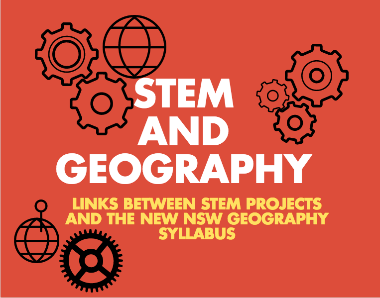 I attended the Department of Education’s STEM Showcase (see the tweet feed at #STEMShowcase). In case you’ve been living under a rock – STEM is Science, Technology, Engineering and Maths. STEM is clearly a movement that is gaining momentum, and my question is where does geography fit into this? Or History? Or Commerce? I have been trying to think of a new acronym to get us in on this movement. If you have any ideas, please let me know. What occurred to me is how many of these STEM projects have very obvious crossovers with humanities subjects, particularly geography. This post will look at a few of the presentations that I saw today and some ideas of how humanities subjects could also be included.
Baulkham Hills High School – Weather TECH Students created a STEM project involving the construction of a weather station. This involved a design process, coding of the equipment, manufacturing the equipment with a 3D printer, and collecting and analysing weather data. In the Science faculty, this was undertaken as part of a student research project. In TAS, students developed skills in using CAD and CAM software and Arduino to design, code and create the equipment. In Maths, students' skills were developed in analysing and presenting the vast amount of weather data collected. Students (and teachers) successfully created a working model with equipment collecting weather data every second. The real world applications to agriculture were emphasised. In the new NSW Geography syllabus the WeatherTECH project would fit easily within the Water In the World topic, particularly Water resources and the Water cycle. It also addresses fieldwork requirements – using weather instruments. Examine the WeatherTECH project site. Bellingen High School - Survive the Shake The topic of this STEM project was earthquake proof buildings. Students designed, produced and evaluated a multi-storey building with a small fooprint, which was specified. Students were provided with a design process to follow which provided a scaffold to follow during project. Students were required to use cheap materials such as straws, toothpicks, marshmallows, etc to create a model of their buildings. Building designs were tested on an earthquake shake table created by the teachers. In the Science faculty, the project tied into content related to earthquake size and magnitude, damage and destruction and prediction of quakes. In Maths it tied in with content related to geometry, 3D design shapes and budgets. The construction of the buildings and the design process involved the TAS faculty. In the new NSW Geography syllabus the Survive the Shake project would fit into Landforms and Landscapes, particularly Geomorphic hazards. This could easily incorporate the inquiry based learning skills in the syllabus. Examine the Survive the Shake project site. Riverside Girls High – Post-Earth Survival The girls at Riverside completed a STEM project examining the requirements to sustain life. Students explored the universe and designed a colony suitable for sustaining life on another planet. Students focused on: What do humans need to survive? The project used a design process from the TAS faculty and this was used to determine project milestones. TAS introduced the students to the tools they would need to complete the project such as Sketch Up, 3D printing, etc. Students brainstormed what it would be like if they were locked inside their house and had to stay there for 2-3 years. What would they need? What would they have to change? Students collected data on energy and water use in their own homes. From a Maths perspective students had to develop problem solving and reasoning skills, as well as data analysis. The project also incorporated the EcoMuve program from Harvard University. Assessment and presentation involved peer review and feedback. In the new NSW syllabus the Post-Earth Survival project would fit into Place and Liveability, particularly Influences and perceptions. This could also incorporate the inquiry based learning skills in the syllabus. Examine the Post-Earth Survival project site. Promoting Geography and boosting numbers A lot of time, effort and money is being spent on promoting STEM to our students. As Geography teachers, we are constantly looking for ways to promote our subject and boost senior numbers. There are plenty of ways to do this, but I think getting involved in STEM projects or at least other cross curriculum projects might be one idea that is worth a bit more consideration. BOSTES announced today that the new Elective 7-10 Geography syllabus is to be implemented in 2017. The remainder of this year is for familiarisation and planning.
Similarly to the new 7-10 Geography syllabus incorporating the Australian curriculum, it includes the Learning Across the Curriculum areas as well as the key geographical concepts of place, space, interconnections, environment, scale, sustainability and change. It includes a concepts continuum outlining which aspects of each concept should be covered in each stage. The geographical inquiry skills continuum and geographical tools continuum have also been included. The Elective course provides opportunity of geographical inquiry. The Stage statements for both Stage 4 and 5 have a whole paragraph emphasising the importance of geographical inquiry. There is an emphasis on problematic knowledge, with students required to investigate challenges, collect primary and secondary data, propose solutions and actions. Students are also required to investigate challenges from a range of different perspectives. Several of the topics allow for the exploration of an investigative study. Interestingly the Elective course is focused almost solely on outcomes and content. The Mandatory Geography course also has inquiry questions to guide each topic and a content focus, neither of which are present in the Elective syllabus. The topics in the new Elective Geography course are: - Physical Geography - Primary Production - Australia's Neighbours - Interactions and Patterns Along a Transcontinental Transect - Oceanography - Global Citizenship - Political Geography - School-developed Option A Life Skills course has been provided as part of the Elective course which aligns with topics of the mainstream course. This will make it manageable for teachers to deliver the Life Skills course within a mainstream classroom. Information is provided on reporting and to guide assessment in both the mainstream and Life Skills course. The syllabus and support documentation can be found on BOSTES: http://www.boardofstudies.nsw.edu.au/syllabus_sc/geography.html BOSTES (formerly the Board of Studies) has recently released the new NSW Geography syllabus for review. This syllabus, unique to NSW, incorporates the Australian Curriculum for Geography already being implemented in other states in Australia.
The draft new syllabus can be found at the BOSTES website along with documents outlining the features of the documents for different groups (Primary, K-10, Life Skills). The draft document does not include a Senior Geography syllabus draft at this stage. The consultation session will only run until August 29, 2014, so it is a fairly brief period. There are a number of opportunities for people to become involved: Individual responses to BOSTES There is an online survey which can be filled in, which is fairly comprehensive but contains closed questions. The survey covers topics such as views on the rationale, aims, topics, whether current resources can be used, whether it caters for a full range of students, etc. You can also make more detailed written submissions which can be emailed directly to the Senior Project Officer, Geography, Brooke Prideaux (email available at the BOSTES page linked above). BOSTES sessions: A number of sessions have been organised by BOSTES during the consultation period. These are to be held at Liverpool, Pennant Hills, Gymea and Ashfield as well as regional sessions at Moruya, Coffs Harbour, Orange and Griffith. Each of these sessions require registration very soon. Check the above-linked BOSTES page for details and links to registration. This is being organised by Eventbrite, but I'm sure that Brooke would the any questions. DEC sessions: For teachers in NSW Public Schools, the DEC Learning and Leadership Directorate are holding consultation sessions to put together a submission on behalf of the DEC. This will be done using Adobe Connect, and registration should be completed through the DEC's Professional Learning database and management system MyPL. The title is "Secondary consultation on the draft Geography K-10 Syllabus" (Course Code: NR06641). This is to take place on Monday 28 July 3.30pm – 4:30 pm. Alana Ellis, the Relieving HSIE Advisor 7-12 is the contact person, and can be contacted through her DEC email. Professional Associations and informal groups: Interestingly, the NSWGTA Annual Conference falls mid way through the consultation period. I suspect that while there doesn't appear to be a consultation session on the agenda (the agenda was released before the draft syllabus) that there may be some slight rearranging of the program to allow time for it. Online groups, such as Geography Teachers Online Australia (Facebook group) are already abuzz with discussions regarding various parts of the new syllabus. This is a great way to hear a few different perspectives and get involved in the debate. Faculties Don't forget that sometimes the best discussions can happen face to face in your own faculty. Consider what the difficulties are of the current syllabus for your students. Will the new syllabus solve these problems? Are there new issues? How will your students cope with the content? Will they find it interesting? What resources do you currently use that will fit in with new syllabus? What are the areas that are going to need a lot of work? What we already know: - Australia already has an agreed Australian Curriculum for Geography. The writing of the curriculum was completed in 2012, involved consultation between states, with professional associations and teachers, and was signed off by federal and state education ministers. There have been no discussions or public announcements about a review of this curriculum at this stage, despite reviews currently taking place of other subjects. - All states/territories but NSW began implementation of the Australian Curriculum for Geography in 2013. Like the Phase 1 subjects (English, Maths, Science, History), BOSTES decided that the structure of the Australian Curriculum was not suitable for NSW teachers, and that it would need to be rewritten to more closely resemble the current/previous syllabi. - BOSTES appointed a Project Manager to oversee the writing of the Geography syllabus for NSW as of January 2014. The former BOS had a procedure for writing new syllabi which involved hiring a team of writers, consulting with stakeholders, reviewing and refining. We can assume that a similar process was followed and that this has taken place between January and July to allow for the new document to be released. - While we are in a consultation period, we can assume that some sections of the syllabus are "locked in" while other parts are open to discussion. These have been labelled in the draft document. Please make sure you take the opportunity to have your say while we have the chance. I was lucky enough to attend the first ever TM Geography a couple of weeks ago. The teachmeet was held at Saint Ignatius' College on Monday 5 and was hosted by Jessica Lonard. Using infographics in assessment Jessica Lonard, our host, began the presentations with a presentation on how to use infographics in assessment of student learning. The room was decorated with examples of her students' work. There are a range of programs that can be used to create these infographics. One of the easiest is Picktochart. Other programs include Infogr.am, visual.ly, and easel.ly. For further information you might like to check out 10 free tools for creating infographics. Spotlight - ABS Sharon McLean presented a session on Spotlight from the Australian Bureau of Statistics which I have discussed in a previous blog: Australia's Population. This program brings population statistics about Australia to life by presenting them in a fun interactive voiced by Shaun Micallef. Flipping the geography classroom Ryan Gill presented a session about the challenges and successes of flipping his classroom including creating the videos, winning over parents and keeping students engaged. Flipping the classroom is a strategy where students are exposed to new material outside of the classroom through the use of videos, readings, etc and then class time is used to consolidate the new learning through activities such as discussions, problem solving and debates. Google Tour builder Mick Law from Contour Education showed us the latest and greatest mapping tools, concentrating mainly on the new Google Tour Builder. This seems to be a much simpler way to create a virtual tour than through Google Earth.  Nearpod Kate Corcoran showed us how she uses Nearpod in her classroom. Nearpod is a program that allows you to set up interactive quizzes and surveys and enables sharing between groups. Students log into a group and can access the resources that the teacher has made available to them on their devices. The teacher can control the students' screen while they are part of the group.  Thinglink Thinglink is a site which enables you to create interactive images. Di Laycock showed us how you can add comments, images, videos and music to create a multimedia experience from a still image.  Creating virtual field sites I went through the process of creating a virtual field site to give students access to field sites which they would not otherwise be able to experience. This is done by combining videos, photos, google tours, and links to articles all combined with the use of a blog site or website builder like weebly. Twitter: #tmgeography   |
||||||||||||||||||||||||||||||