|
The cartoons below have been embedded from the Sydney Morning Herald and the Daily Telegraph.
Cartoons are a form of visual representation of ideas, views and concepts. It is important that students develop skills in interpreting cartoons. Interpreting cartoons involves knowledge of the context of the cartoon, identifying different issues being explored in the cartoon, identifying the techniques used by the artist, and considering the views or opinions that the artist is trying to convey. Basics: - What is the cartoon about? - Who is represented in the cartoon? Why? Knowledge of the context: - What events have happened? - Look at the date of the cartoon. What events had happened at the time the cartoon had been drawn? - Who are the key people/roles involved in the event/issue? Identifying issues explored: - What can you see in the cartoon? What words are used? - What concepts are being explored? Techniques: - Has the artist used symbolism, irony, analogy or exaggeration in communicating? - Is the cartoon persuasive? Views and opinions: - Can you identify the political views or perspective of the artist? - How are these views or perspective communicated? - What other opinions are there about this issue?
1 Comment
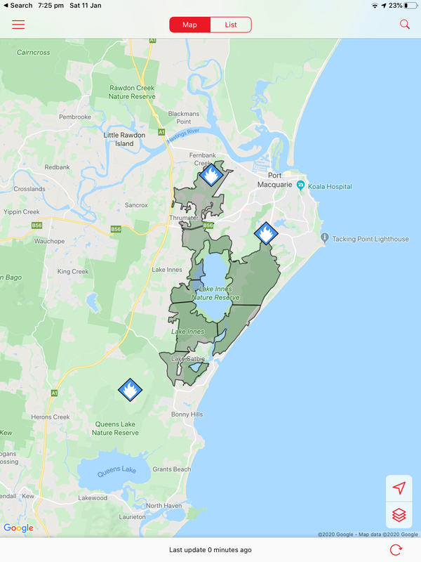
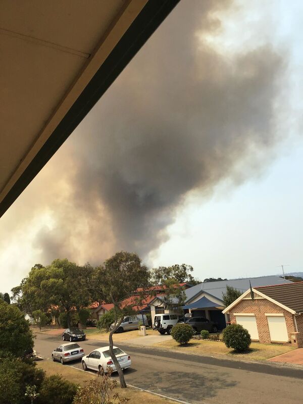
Fires around Port Macquarie, Lake Cathie and Lake Innes began in November 2019. As of 21 January the Crestwood Drive, Port Macquarie fire had burnt out 3572ha, while the connected Lindfield Park rd, Port Macquarie fire had burnt out 859ha.
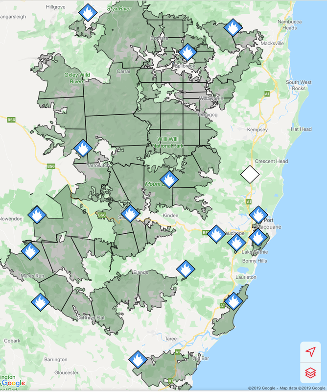
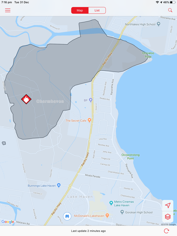
The Lake Innes Nature Reserve was home to a flourishing koala colony. Between 350 and 600 koalas are believed to have died in the fires around the Lake Innes area. The image on the left is a screenshot of the RFS Fires Near Me app showing the location and extent of the Port Macquarie fires. The screenshot on the right shows the size of the Port Macquarie fires in relation to other fires in the mid-North Coast region.
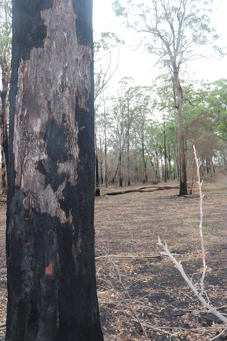
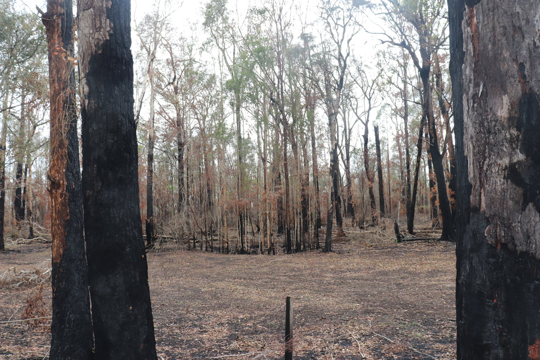
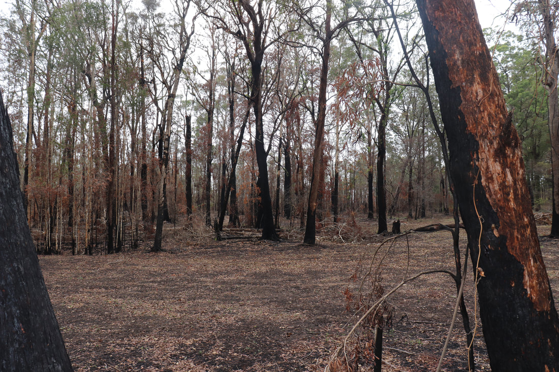
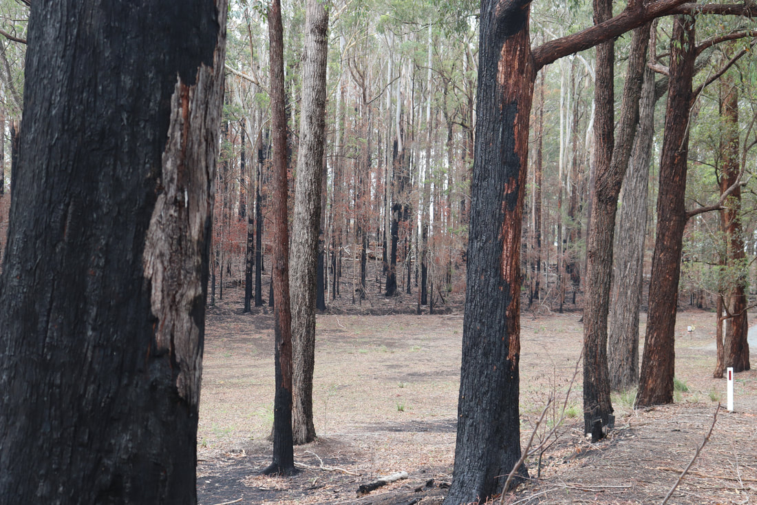
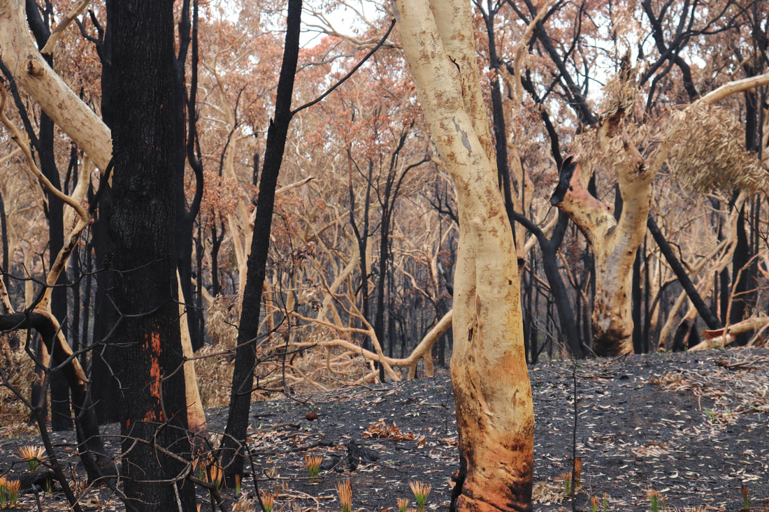
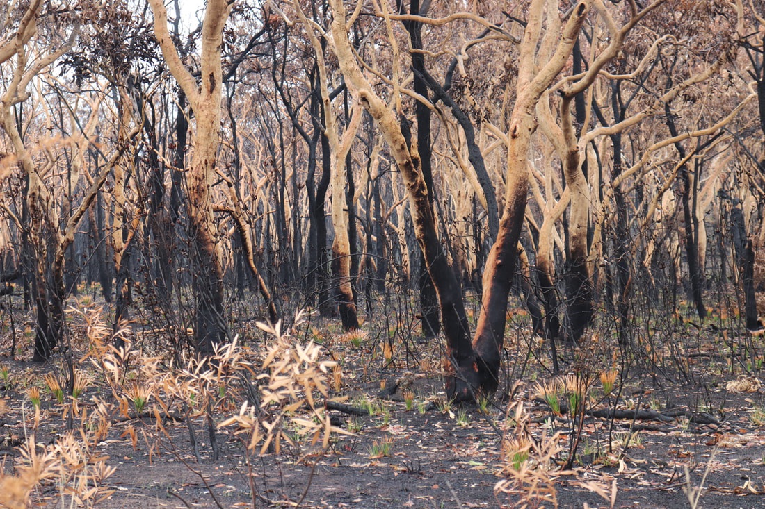
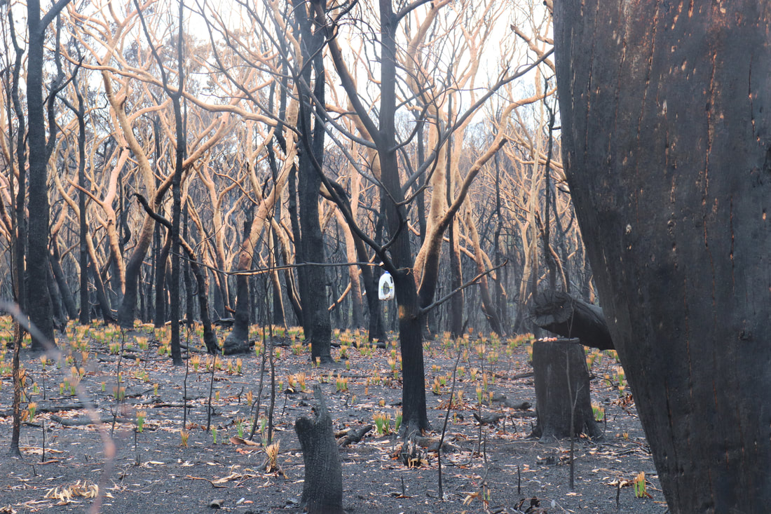
Photos below show the aftermath of the fire - taken on 17 January, 2020.
The post below from NSW National Parks and Wildlife Services indicate that while the fire around Lake Innes was extinguished, there remains risk for future fires flaring even several months later. The post below was posted on January 21.
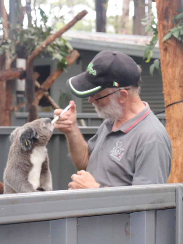
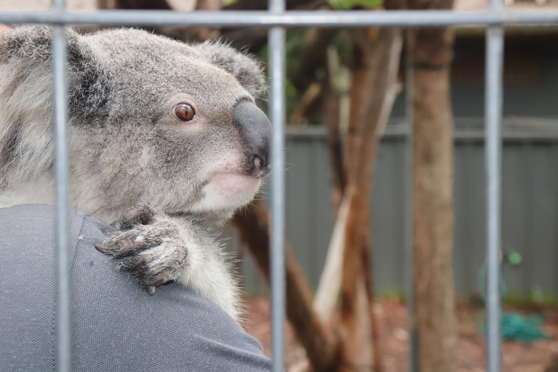
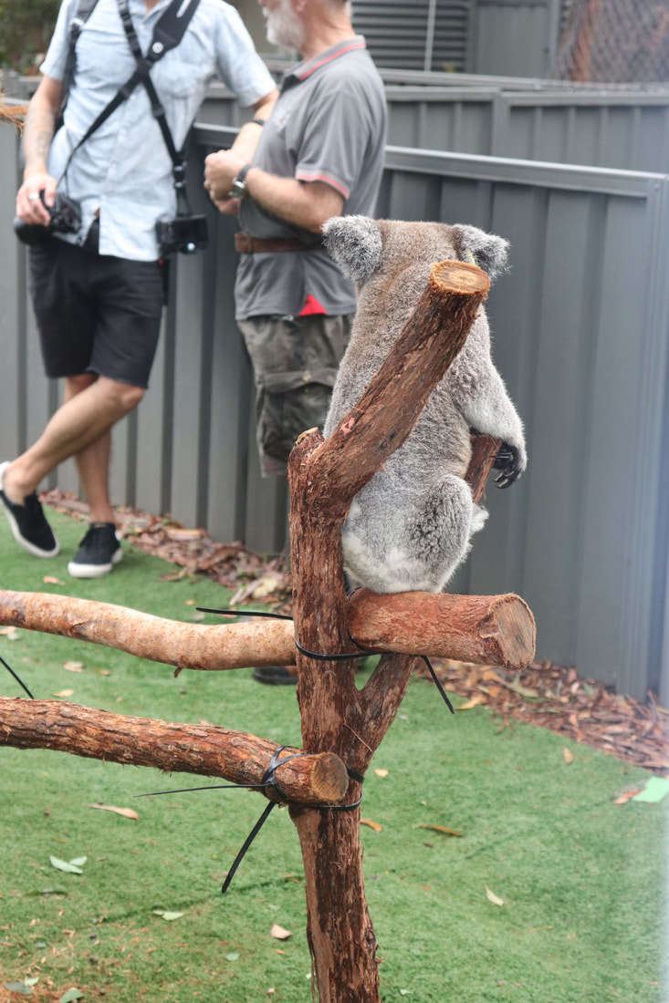
Port Macquarie Koala Hospital
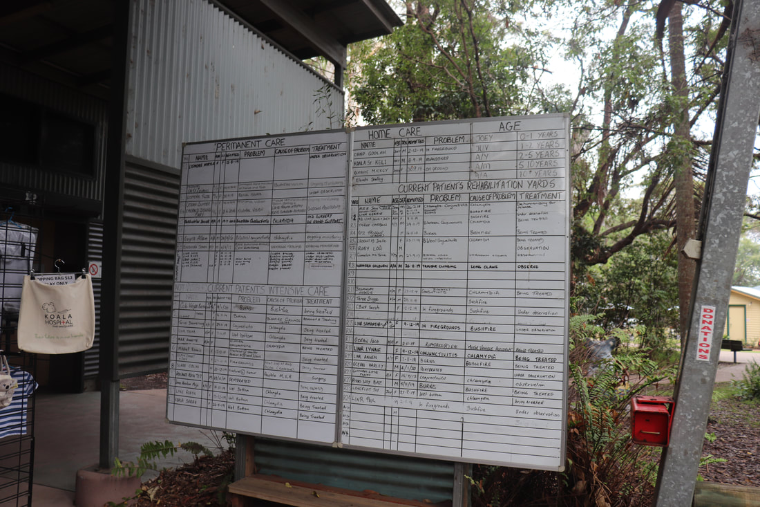
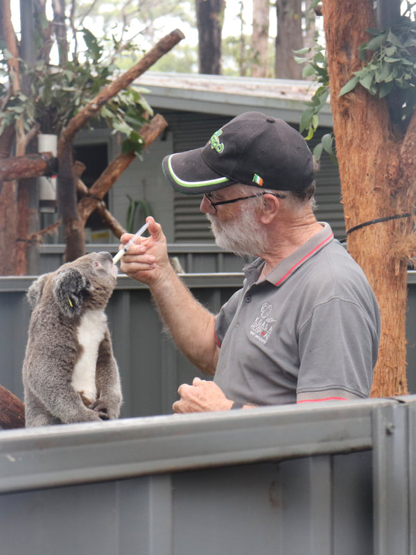
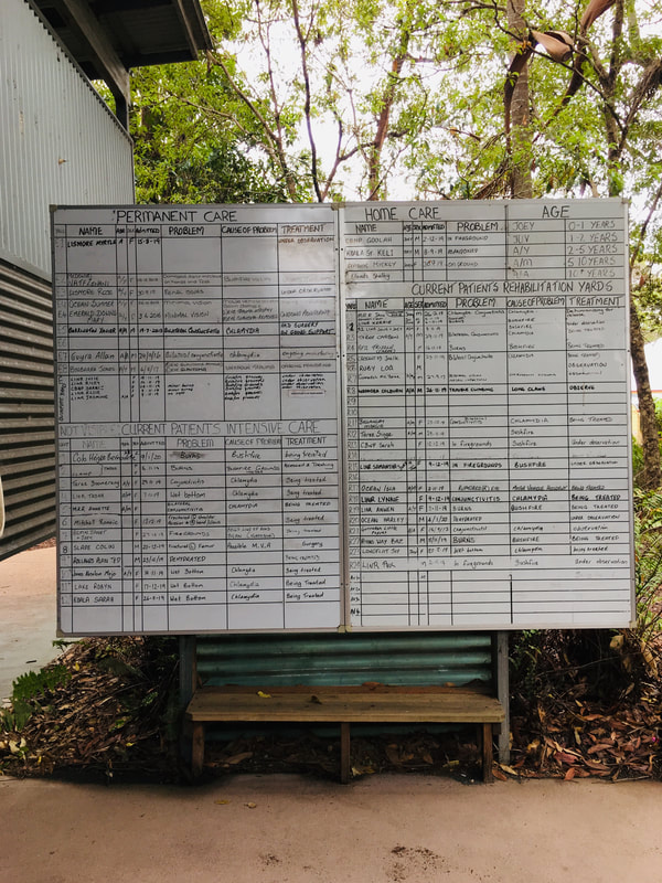
Following the fire a number of injured koalas required intensive care. The Port Macquarie Koala Hospital was inundated 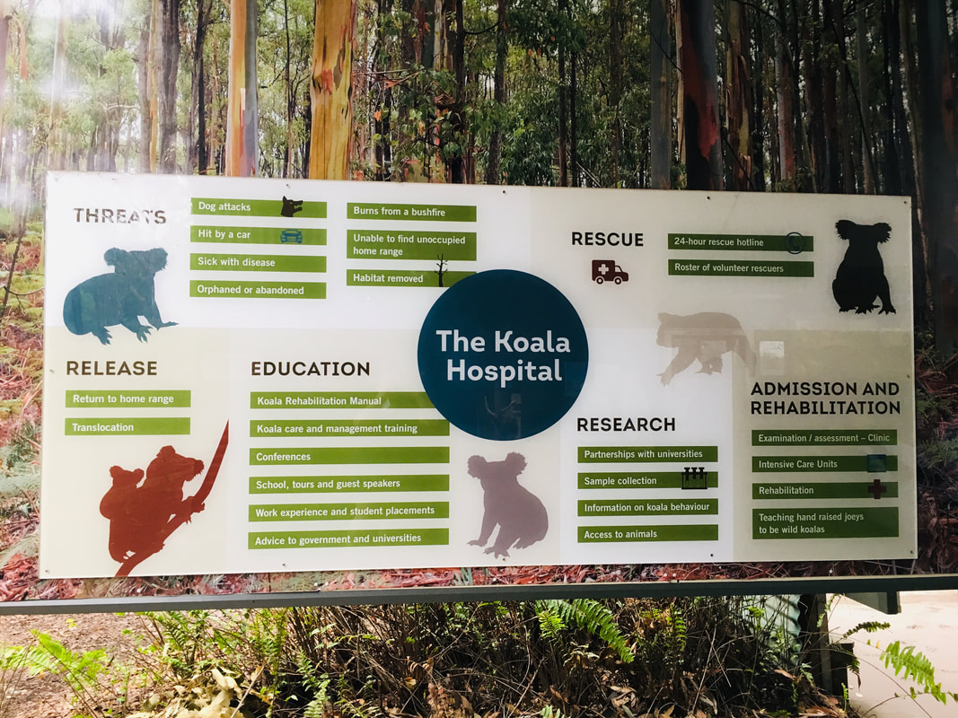
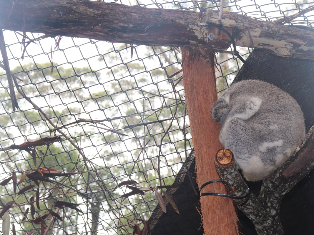
The Port Macquarie Koala Hospital has a large number of koalas in care. The least injured/ill koalas are available for public viewing, while those most injured are screened from public viewing for their own wellbeing. Below is an example of the management of koalas, their injury/illness and treatment.
Go Fund Me Campaign
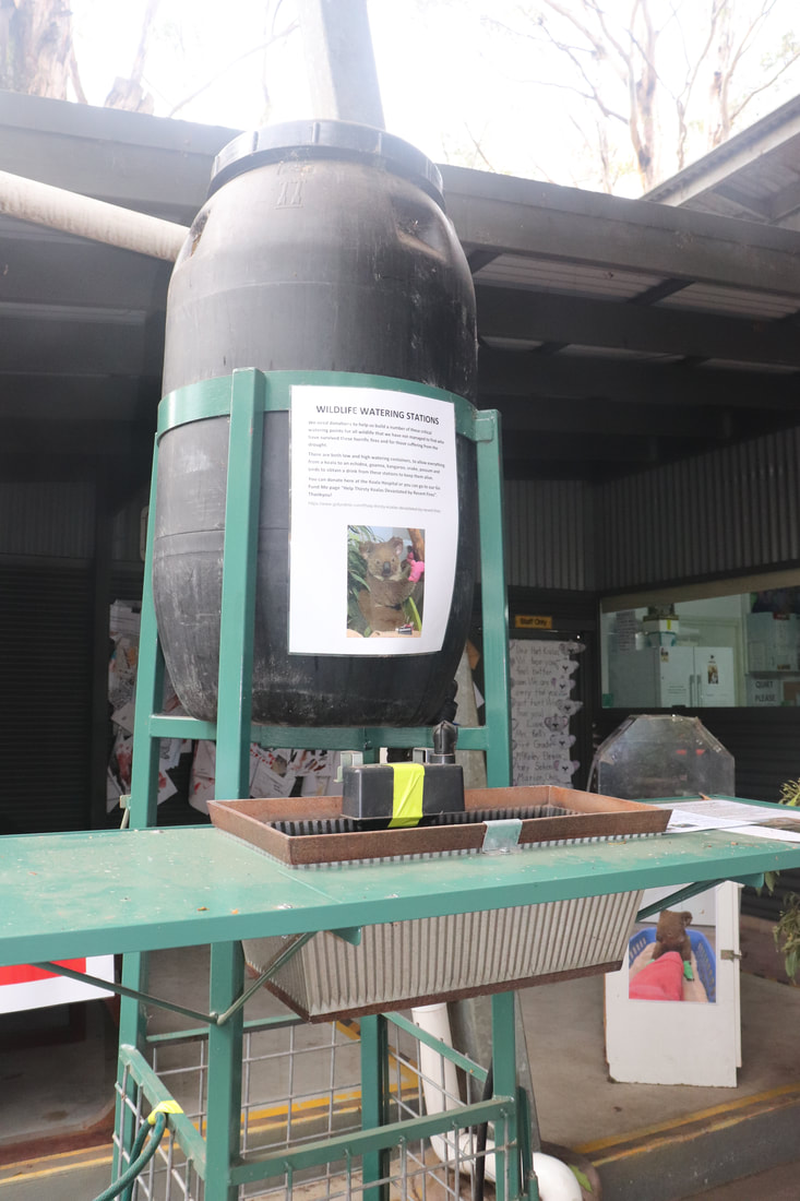
Port Macquarie Koala Hospital set up a Go Fund Me Page to raise much needed funds to support care for injured koalas and to establish drinking stations and a breeding program for koalas in the region. The initial goal was for $25,000. By 21 January, the campaign had raised nearly $7.5 million dollars. The scope of the projects originally proposed have now been expanded in light of the huge amount of money raised. Port Macquarie Koala Hospital - Go Fund Me. Spatial dimensions and nature of a contemporary ecological hazard
- Sydney temperatures pass 41C as firefighters injured, homes destroyed, state of emergency declared - Bushfire survival supersedes Christmas plans as firefighters battle infernos - Western Australia bushfire out of control as temperatures expected to surge above 40C - What we know so far about the Australian bushfires crisis on New Year's Eve - Australia fires: A visual guide to the bushfire crisis - Australia wildfires: Blazes merge into massive inferno as experts warn species will go extinct - A timeline of the ring of fire around NSW, Victoria and the ACT. - Aerial footage shows bushfires raging in the Australian state of Victoria - "Uncharted territory": Berejiklian says fire crisis in unprecedented. - Two fires have been upgraded to an emergency level as the state looks at a horror afternoon. Characteristics of the natural environment, including the physical processes and cycles influencing the nature and occurrence of the hazard - When bushfires make their own weather - Australian firefighters warn of uncontrollable blazes as conditions worsen - NSW bushfires surround Sydney but conditions ease for now - Winds and high temperatures increase fire danger across southern NSW - Some say we’ve seen bushfires worse than this before. But they’re ignoring a few key facts - When bushfires make their own weather. - Intense "firestorms" forming from Australia's deadly wildfires. - Supercell bushfire thunderstorms, tornadoes, fire-whirls and other deadly fires that spin. - The bushfires in Australia are so big they're generating their own weather - "pyrocumulonimbus" thunderstorms that can start more fires. Human–environment interactions and evidence of change, including: The contribution of human activities to hazard events - How humans kicked off the Pyrocene, a new ‘age of fire’ Preparedness Full List of Fire and Emergency Chiefs' recommendations to the Federal Government. A load of rubbish: Greg Mullins says he wants a more proactive approach to fires and climate change Prescribed burning: what is it and will more reduce bushfire risks? Change in relation to climate - Weather disasters cost $150bn in 2020, revealing impact of climate change – report - Climate change is already here: major scientific report - Rising levels of carbon dioxide increasing extreme weather events in Australia, report finds - Frequent extreme bushfires are our new reality: We need to learn how to live with smoke-filled air - The facts about climate change and bushfires - Here’s why Australia is having a cataclysmic wildfire season - The facts about bushfires and climate change - Experts warn extreme bushfire weather risk growing - Climate change fueled the Australia fires. Now those fires are fueling climate change. - BBC on Australian bushfires - Weirs continued to flow through drought and fires - This is not normal: Explaining Bushfires and Climate Change - Bushfire survival supersedes Christmas plans as firefighters battle infernos - How to monitor the bushfires raging across Australia. - Explainer: What are the underlying causes of Australia's shocking bushfire season - Bureau of Meteorology chart shows how temperatures have soared in Australia in the past century Challenges, opportunities, and responses, including: Changes to natural processes, systems and/or environments - Endangered corroborree frogs survive bushfires - Water catchments are covered in bushfire ash, what will happen when it rains? - NSW endures longest spell of air pollution on record as bushfires flare near Sydney - The big smoke: how bushfires cast a pall over the Australian summer - Huge areas of national parks, heritage locations hit by bushfires - Number Of Animals Feared Dead In Australia’s Wildfires Soars To Over 1 Billion - We need to talk about the impact the bushfires are having on insects - 'It’s huge': Fears 80 per cent of NSW’s iconic Blue Mountains lost to bushfires - Hundreds of thousands of fish dead in NSW as bushfire ash washed into river - Native plants can flourish after bushfire, but there’s only so much hardship they can take - A season in hell: bushfires push at least 20 threatened species closer to extinction Impacts on people and communities - Bushfire smoke and climate inertia dents Sydney's reputation - Australian wildfires threaten Sydney water supplies - Nation counts cost of Australian blazes after communities devastated – as it happened - Bushfire death toll rises as fires sweep across South Australia and NSW - NSW endures longest spell of air pollution on record as bushfires flare near Sydney - Counting the cost of Australia's bushfires - Sydney's drinking water could be polluted by bushfire ash in Warragamba Dam catchment, expert says - Homes believed lost in NSW 'mega blaze' as firefighters tackle 70-metre flames in windy conditions - Sydney smoke at its 'worst ever' with air pollution in some areas 12 times 'hazardous' threshold - 'Not a good look': Bushfire smoke threatens to pollute Sydney's tourist image - Volunteers struggling to cope with post-traumatic stress as bushfires rage on - 'We've lost our beautiful town': Mogo residents flee as bushfire rages up NSW south coast - Australia's raging fires will create big problems for fresh drinking water - NSW and Canberra fires: more homes reported lost as wind and thunderstorms hit - Despair and destruction in Cobargo: 'Most people are running dead' - Grave fears held for hundreds of important NSW south coast Indigenous sites - Australia's bushfire smoke will do a full lap of the earth: NASA Risk-management policies, procedures and practices at a range of scales, eg prevention, mitigation, preparedness and resilience-building - Australia faces 'massive' rethink to prepare for long-term bushfires and air pollution - Aboriginal fire management – part of the solution to destructive bushfires - Hazard reduction burns are not a 'panacea' for bushfire risk, RFS boss says - Factcheck: are national parks 'locked up' and more vulnerable to bushfires? - Government buried climate risk action plan - How First Australians' ancient knowledge can help us survive the bushfires of the future - Hazard reduction burn benefits undercut by weather, costs - ‘It's miraculous’: Owners say cultural burning saved their property - Fivefold increase in funding for hazard reduction burns needed, experts warn - Bushfires Hazard Reduction and backburning Varying perspectives - Yes, Prime Minister, it is a national disaster and we need a frank discussion - I am a volunteer firefighter. Yes, we 'want to be here', Scott Morrison – but there are limits - Australia's lungs have collapsed and Generation X needs to take part of the blame - Bushfire survival stories emerge from New Year's Eve blazes in Victoria's east - Morrison is now counting the cost of climate denialism - Strength from perpetual grief: how Aboriginal people experience the bushfire crisis - There is no strong, resilient Australia without deep cuts to greenhouse gas emissions - Behind the smokescreen, the Coalition's stance on climate change hasn't changed at all - Prime Minister slaps down NSW Environment Minister over climate change comments - 'Nonsense': David Attenborough highlights problem behind bushfire crisis The effectiveness of people and organisations in managing ONE contemporary hazard event at a selected place - Hawaiian-themed mural of Scott Morrison pops up in Sydney - 'Hugely disappointed' emergency chiefs to hold bushfire summit with or without PM - 'The government has abandoned its own people': Bushfire evacuees call for climate action - Dam levels reach two-year high, RFS declares all fires now contained - Fire near Port Macquarie extinguished after 210 days - 'We're all just waiting': NSW south coast residents still in limbo three months after bushfires - Post-bushfire logging makes a bad situation even worse, but the industry is ignoring the science - Watching our politicians fumble through the bushfire crisis, I’m overwhelmed by déjà vu Skills - Mapping Australia’s Bushfires
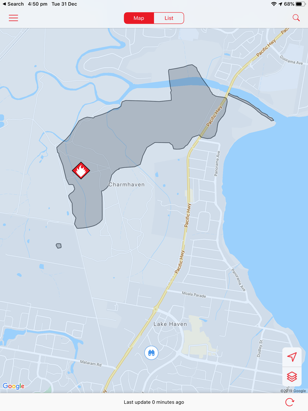
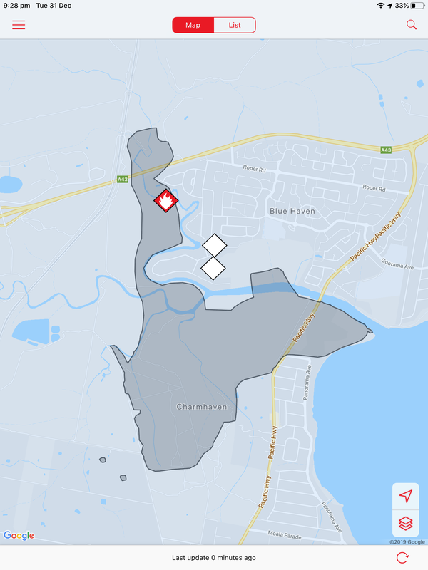
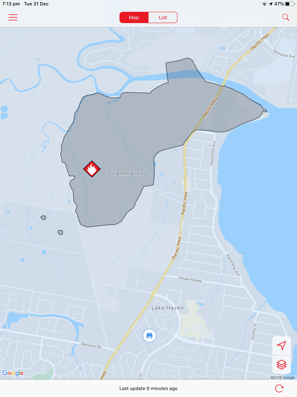
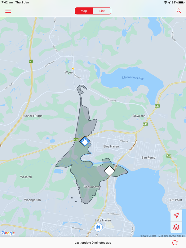
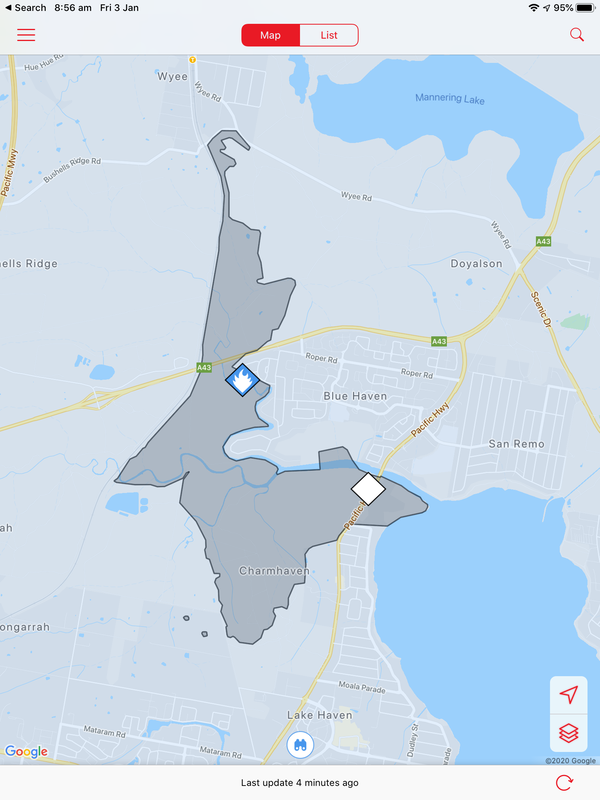
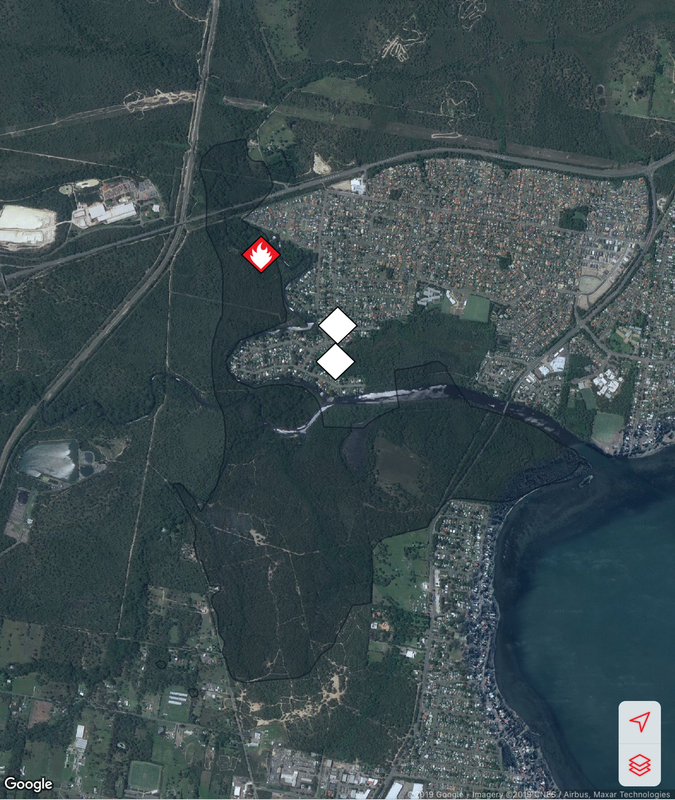
A bushfire started on December 31 at Charmhaven on the Central Coast and burned over several days. This is one of the smaller fires in The Australian Bushfires 2019-2020, but still burnt out 418ha of land. Local residents were issued with warnings and in some cases were evacuated. Two homes, located on Birdwood Drive and Arizona Drive were lost.
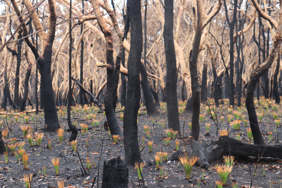
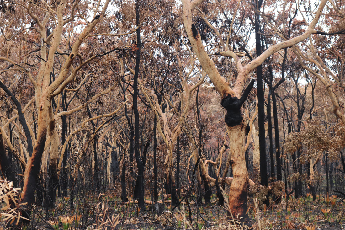
The photos below show the aftermath of the fire, taken on 18 January. There is some evidence of regrowth, but the fire-ground still smelt of smoke and was still hot underfoot.
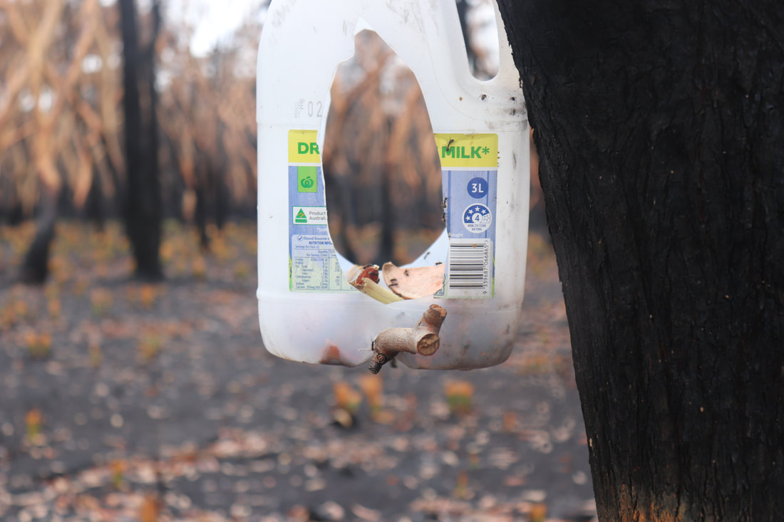
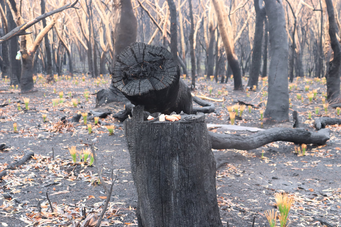
Community groups have attempted to rescue injured wildlife and provide food for them. Below are photos of food left in a hanging container and food left on a tree stump.
Coordination of feeding and watering stations has been aided by the using of spatial technologies such as Google maps.
A Water Our Wildlife CCWSAR Map has been developed to help volunteers know where feeding and watering stations have been set up, so that people can visit them independently and re-stock them.. 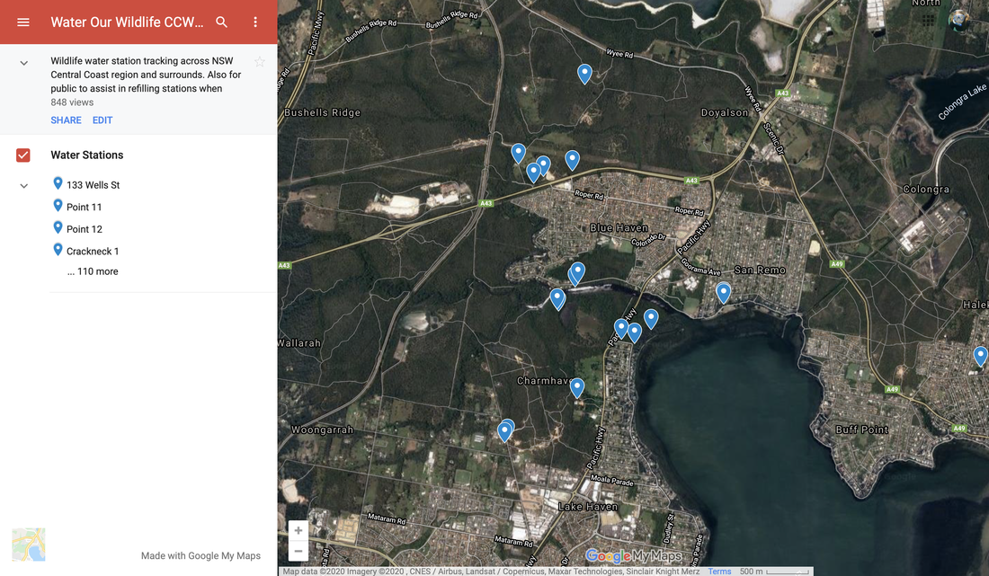
Victoria – Joint Task Force 646
Following a request from Victorian Premier, Daniel Andrews, on December 31, naval vessels, helicopter and fixed wing military aircraft were made ready for use in evacuations. This was decided in consultation with the Prime Minister and Defence Chief General Angus Campbell. HMAS Choules transported approximately 1100 evacuees from Mallacoota to Western Port on January 4-5. The ship then returned to Mallacoota to deliver diesel fuel and a fuel management team to keep generators running. RAAF Black Hawk and Taipan helicopters transported firefighters to fire grounds, and helped evacuate vulnerable people. Three Spartan aircraft assisted with evacuations. On January 5 and 6 ADF flew in emergency food, fuel, water and medical supplies to 18 cut-off communities. On January 7 they prepared a staging area for around 100 international fire fighters around Omeo. On January 7, further evacuations from Mallacoota took place, and satellite phones and food, medical supplies, water and fuel were delivered in some isolated locations, including Bemm River and Genoa. Reconnaissance flights were conducted over fire affected areas on January 8. A medical team was deployed to remote towns such as Combienbar and Gipsy Point. 5400 litres of diesel and 800 litres of unleaded petrol were flown in to Mallacoota. Equipment and Engineering personnel were provided to assist state government in reopening roads, removing debris and clearing fire breaks and fire trails. On January 9, ADF undertook route clearance north of Bairnsdale and the Great Alpine Road was reopened. Hay bales and fodder were moved into key locations. Air Force air traffic controllers assisted to help manage the large volume of air traffic at the Bairnsdale Airport. From January 10, ADF undertook continued work in support of relief centres at Omeo, Swifts Creek, Bairnsdale, Orbost and Mallacoota. ADF also supported evacuations from the Victorian Alpine region. Activities Undertake internet research: - Make a list of the different issues affecting the people of Mallacoota prior to the ADF assisting them? - Make a list of the different tasks undertaken by The Australian Defence Force to assist the people of Mallacoota? - Why do you think that The Australian Defence Force had to be called in to assist the people of Mallacoota? Was this a good decision? What are the costs and benefits of using the ADF in this way? - What challenges did the ADF face in assisting the people of Mallacoota? Extended response: - Outline the effectiveness of The Australian Defence Force in responding to the bushfire crisis affecting Mallacootta. Media analysis: Embedded below are social media posts from The Guardian, The Australian Defence Force, the Royal Australian Army and the Royal Australian Airforce. - What is the purpose of The Australian Defence Force, Royal Australian Army and the Royal Australian Airforce posting updates about their activities? What are the benefits of these posts? - Consider the following statement about media: "Media and media messages can influence beliefs, values, attitudes, behaviours and the democratic process." What messages are conveyed in the posts below? What values are communicated? How might these posts influence democratic processes?
Embedded below is a series of tweets by Brendan, a local resident of Mallacoota. As the emergency unfolded, he published updates on the progress of the fires and the experiences of him and his family, and later on his community. The tweets included below are just from the first few days of the disaster. You can also listen to an interview with Brendan by clicking here.
Unlike a formal newspaper article or a television news story, this is a very personal account, describing one man's individual experiences. Activities - Create a list of the impacts of the fire on this particular person. - Create a list of impacts on the community of Mallacoota. - Use the hashtags #Mallacoota, #Australianbushfires and/or #bushfires to search Twitter. Explore the perspectives of other residents during the emergency. Add to your lists above, and write a short description of the accounts of these individuals. - Consider the language and the descriptions included in the accounts you have read. How do these differ from the language and descriptions in more formal pieces of writing or news such as newspaper articles or news reports? - As a geographer, what are the advantages of reading personal accounts of a natural disaster such as the Australian Bushfires? What are the disadvantages? - What steps could you take to verify the accounts of individuals on twitter or other forms of social media?
A range of spatial technologies have been used during and after the Australian Bushfires 2019-2020. Emergency Services have used apps to communicate with the public about the location of fires and the risk to the public. Members of the public have been able to refer to geospatial information about air quality and weather conditions, and following the fires, environmental groups have been able to use geospatial tools to communicate and coordinate locations of feeding and watering stations for wildlife.
MyFireWatch MyFireWatch is a collaboration between Edith Cowan University and Landgate and tracks bushfires. https://myfirewatch.landgate.wa.gov.au 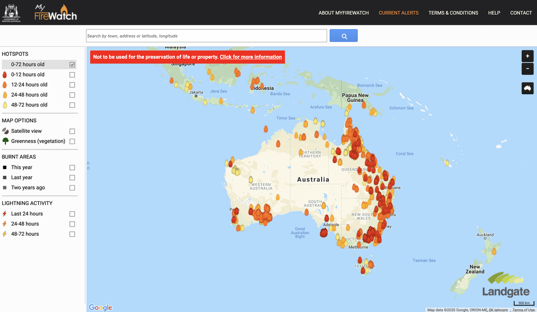 Current Bushfires Current Bushfires is the Queensland Government - Rural Fire Service website. https://www.ruralfire.qld.gov.au/map/Pages/default.aspx 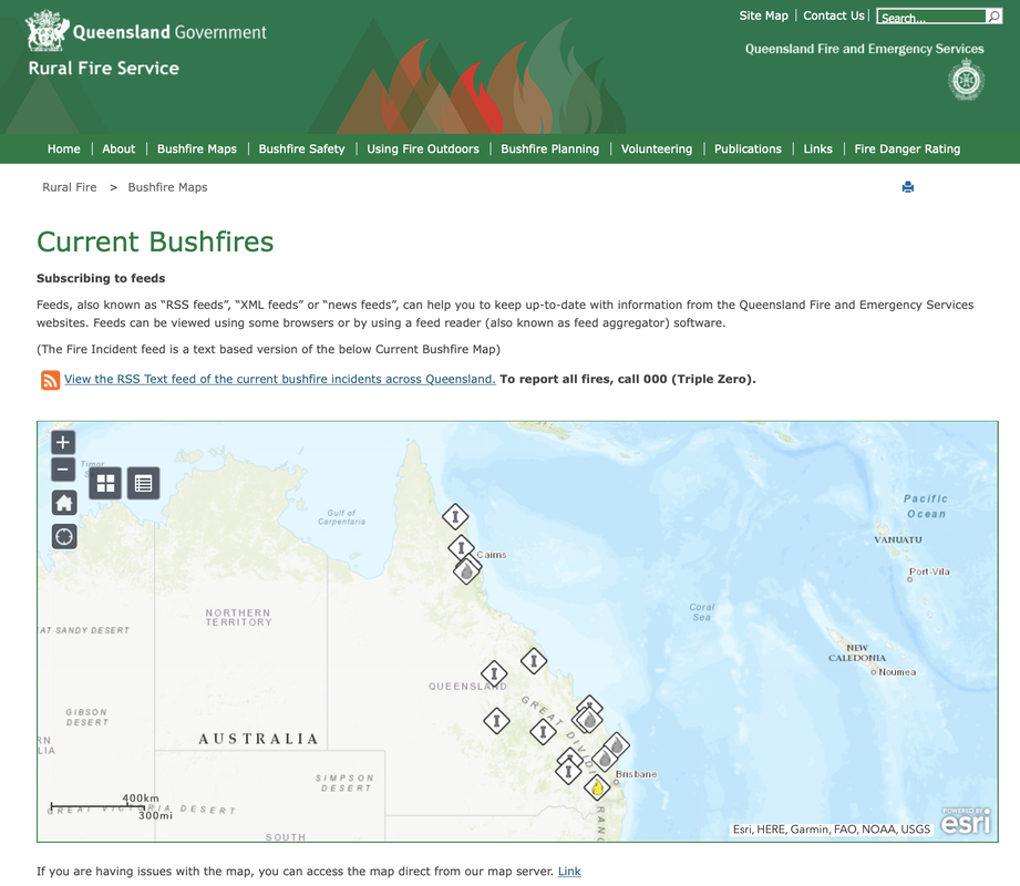 Air Quality Index Visual Map The Air Quality Index Visual Map uses Air Quality Monitoring stations to collect data about air quality and represent it spatially. Air Quality is categorised as Good, Moderate, Unhealthy for Sensitive Groups, Unhealthy, Very Unhealthy, Hazardous. http://aqicn.org/here/ 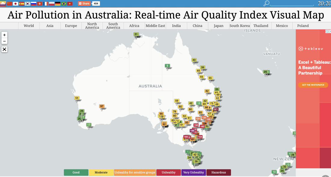 Bureau of Meteorology The Australian Bureau of Meteorology website provides up to date information about weather conditions that may impact on bushfires, such as temperature and wind. http://www.bom.gov.au/products/national_radar_sat.loop.shtml 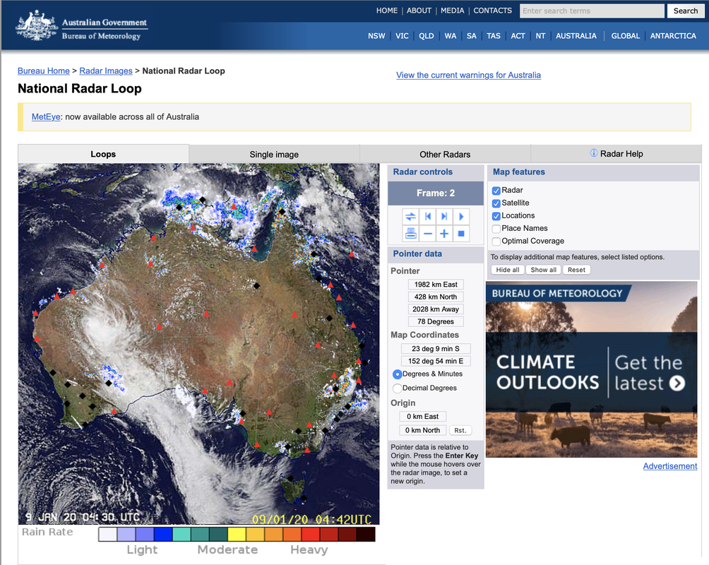 Water Our Wildlife CCWSAR Map The Central Coast Wildlife Search and Rescue created a google map to share information about feeding and watering stations to help surviving wildlife. This enables volunteers to independently visit sites for restocking. Water Our Wildlife CCWSAR Map  Some generic bushfire lesson plans and sequences: GTA NSW - Geography Alive - Bushfire Hazards in Australia Bushfire lesson plan - Australian Institute of Disaster Resilience Bushfire Education - Victorian Curriculum and Assessment Authority Preparing for an emergency - NSW Rural Fire Service Bushfires and grassfires - CFA, Victoria Learning about Bushfires - Victorian Curriculum and Assessment Authority
|
|||||||||||||||||||||||||||||||||||||||||||||||