0 Comments
Spatial dimensions and nature of a contemporary ecological hazard
- Sydney temperatures pass 41C as firefighters injured, homes destroyed, state of emergency declared - Bushfire survival supersedes Christmas plans as firefighters battle infernos - Western Australia bushfire out of control as temperatures expected to surge above 40C - What we know so far about the Australian bushfires crisis on New Year's Eve - Australia fires: A visual guide to the bushfire crisis - Australia wildfires: Blazes merge into massive inferno as experts warn species will go extinct - A timeline of the ring of fire around NSW, Victoria and the ACT. - Aerial footage shows bushfires raging in the Australian state of Victoria - "Uncharted territory": Berejiklian says fire crisis in unprecedented. - Two fires have been upgraded to an emergency level as the state looks at a horror afternoon. Characteristics of the natural environment, including the physical processes and cycles influencing the nature and occurrence of the hazard - When bushfires make their own weather - Australian firefighters warn of uncontrollable blazes as conditions worsen - NSW bushfires surround Sydney but conditions ease for now - Winds and high temperatures increase fire danger across southern NSW - Some say we’ve seen bushfires worse than this before. But they’re ignoring a few key facts - When bushfires make their own weather. - Intense "firestorms" forming from Australia's deadly wildfires. - Supercell bushfire thunderstorms, tornadoes, fire-whirls and other deadly fires that spin. - The bushfires in Australia are so big they're generating their own weather - "pyrocumulonimbus" thunderstorms that can start more fires. Human–environment interactions and evidence of change, including: The contribution of human activities to hazard events - How humans kicked off the Pyrocene, a new ‘age of fire’ Preparedness Full List of Fire and Emergency Chiefs' recommendations to the Federal Government. A load of rubbish: Greg Mullins says he wants a more proactive approach to fires and climate change Prescribed burning: what is it and will more reduce bushfire risks? Change in relation to climate - Weather disasters cost $150bn in 2020, revealing impact of climate change – report - Climate change is already here: major scientific report - Rising levels of carbon dioxide increasing extreme weather events in Australia, report finds - Frequent extreme bushfires are our new reality: We need to learn how to live with smoke-filled air - The facts about climate change and bushfires - Here’s why Australia is having a cataclysmic wildfire season - The facts about bushfires and climate change - Experts warn extreme bushfire weather risk growing - Climate change fueled the Australia fires. Now those fires are fueling climate change. - BBC on Australian bushfires - Weirs continued to flow through drought and fires - This is not normal: Explaining Bushfires and Climate Change - Bushfire survival supersedes Christmas plans as firefighters battle infernos - How to monitor the bushfires raging across Australia. - Explainer: What are the underlying causes of Australia's shocking bushfire season - Bureau of Meteorology chart shows how temperatures have soared in Australia in the past century Challenges, opportunities, and responses, including: Changes to natural processes, systems and/or environments - Endangered corroborree frogs survive bushfires - Water catchments are covered in bushfire ash, what will happen when it rains? - NSW endures longest spell of air pollution on record as bushfires flare near Sydney - The big smoke: how bushfires cast a pall over the Australian summer - Huge areas of national parks, heritage locations hit by bushfires - Number Of Animals Feared Dead In Australia’s Wildfires Soars To Over 1 Billion - We need to talk about the impact the bushfires are having on insects - 'It’s huge': Fears 80 per cent of NSW’s iconic Blue Mountains lost to bushfires - Hundreds of thousands of fish dead in NSW as bushfire ash washed into river - Native plants can flourish after bushfire, but there’s only so much hardship they can take - A season in hell: bushfires push at least 20 threatened species closer to extinction Impacts on people and communities - Bushfire smoke and climate inertia dents Sydney's reputation - Australian wildfires threaten Sydney water supplies - Nation counts cost of Australian blazes after communities devastated – as it happened - Bushfire death toll rises as fires sweep across South Australia and NSW - NSW endures longest spell of air pollution on record as bushfires flare near Sydney - Counting the cost of Australia's bushfires - Sydney's drinking water could be polluted by bushfire ash in Warragamba Dam catchment, expert says - Homes believed lost in NSW 'mega blaze' as firefighters tackle 70-metre flames in windy conditions - Sydney smoke at its 'worst ever' with air pollution in some areas 12 times 'hazardous' threshold - 'Not a good look': Bushfire smoke threatens to pollute Sydney's tourist image - Volunteers struggling to cope with post-traumatic stress as bushfires rage on - 'We've lost our beautiful town': Mogo residents flee as bushfire rages up NSW south coast - Australia's raging fires will create big problems for fresh drinking water - NSW and Canberra fires: more homes reported lost as wind and thunderstorms hit - Despair and destruction in Cobargo: 'Most people are running dead' - Grave fears held for hundreds of important NSW south coast Indigenous sites - Australia's bushfire smoke will do a full lap of the earth: NASA Risk-management policies, procedures and practices at a range of scales, eg prevention, mitigation, preparedness and resilience-building - Australia faces 'massive' rethink to prepare for long-term bushfires and air pollution - Aboriginal fire management – part of the solution to destructive bushfires - Hazard reduction burns are not a 'panacea' for bushfire risk, RFS boss says - Factcheck: are national parks 'locked up' and more vulnerable to bushfires? - Government buried climate risk action plan - How First Australians' ancient knowledge can help us survive the bushfires of the future - Hazard reduction burn benefits undercut by weather, costs - ‘It's miraculous’: Owners say cultural burning saved their property - Fivefold increase in funding for hazard reduction burns needed, experts warn - Bushfires Hazard Reduction and backburning Varying perspectives - Yes, Prime Minister, it is a national disaster and we need a frank discussion - I am a volunteer firefighter. Yes, we 'want to be here', Scott Morrison – but there are limits - Australia's lungs have collapsed and Generation X needs to take part of the blame - Bushfire survival stories emerge from New Year's Eve blazes in Victoria's east - Morrison is now counting the cost of climate denialism - Strength from perpetual grief: how Aboriginal people experience the bushfire crisis - There is no strong, resilient Australia without deep cuts to greenhouse gas emissions - Behind the smokescreen, the Coalition's stance on climate change hasn't changed at all - Prime Minister slaps down NSW Environment Minister over climate change comments - 'Nonsense': David Attenborough highlights problem behind bushfire crisis The effectiveness of people and organisations in managing ONE contemporary hazard event at a selected place - Hawaiian-themed mural of Scott Morrison pops up in Sydney - 'Hugely disappointed' emergency chiefs to hold bushfire summit with or without PM - 'The government has abandoned its own people': Bushfire evacuees call for climate action - Dam levels reach two-year high, RFS declares all fires now contained - Fire near Port Macquarie extinguished after 210 days - 'We're all just waiting': NSW south coast residents still in limbo three months after bushfires - Post-bushfire logging makes a bad situation even worse, but the industry is ignoring the science - Watching our politicians fumble through the bushfire crisis, I’m overwhelmed by déjà vu Skills - Mapping Australia’s Bushfires A range of spatial technologies have been used during and after the Australian Bushfires 2019-2020. Emergency Services have used apps to communicate with the public about the location of fires and the risk to the public. Members of the public have been able to refer to geospatial information about air quality and weather conditions, and following the fires, environmental groups have been able to use geospatial tools to communicate and coordinate locations of feeding and watering stations for wildlife.
MyFireWatch MyFireWatch is a collaboration between Edith Cowan University and Landgate and tracks bushfires. https://myfirewatch.landgate.wa.gov.au 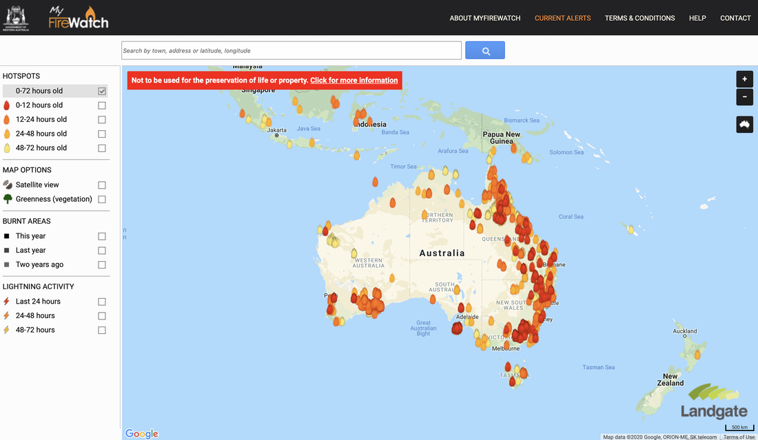 Current Bushfires Current Bushfires is the Queensland Government - Rural Fire Service website. https://www.ruralfire.qld.gov.au/map/Pages/default.aspx 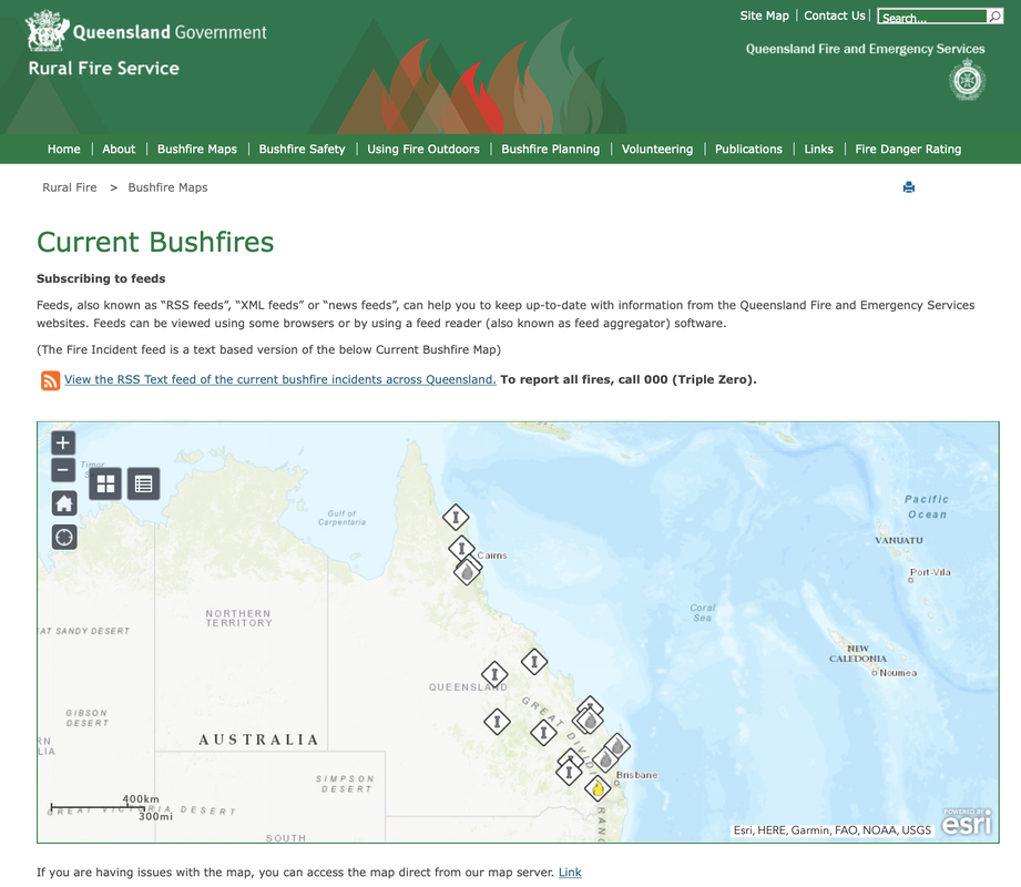 Air Quality Index Visual Map The Air Quality Index Visual Map uses Air Quality Monitoring stations to collect data about air quality and represent it spatially. Air Quality is categorised as Good, Moderate, Unhealthy for Sensitive Groups, Unhealthy, Very Unhealthy, Hazardous. http://aqicn.org/here/ 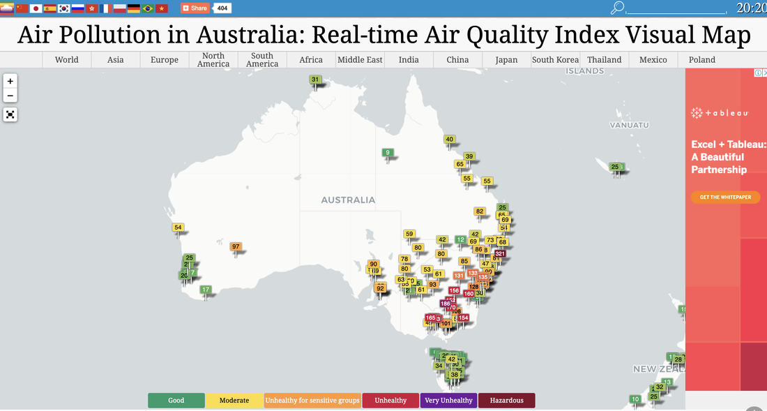 Bureau of Meteorology The Australian Bureau of Meteorology website provides up to date information about weather conditions that may impact on bushfires, such as temperature and wind. http://www.bom.gov.au/products/national_radar_sat.loop.shtml 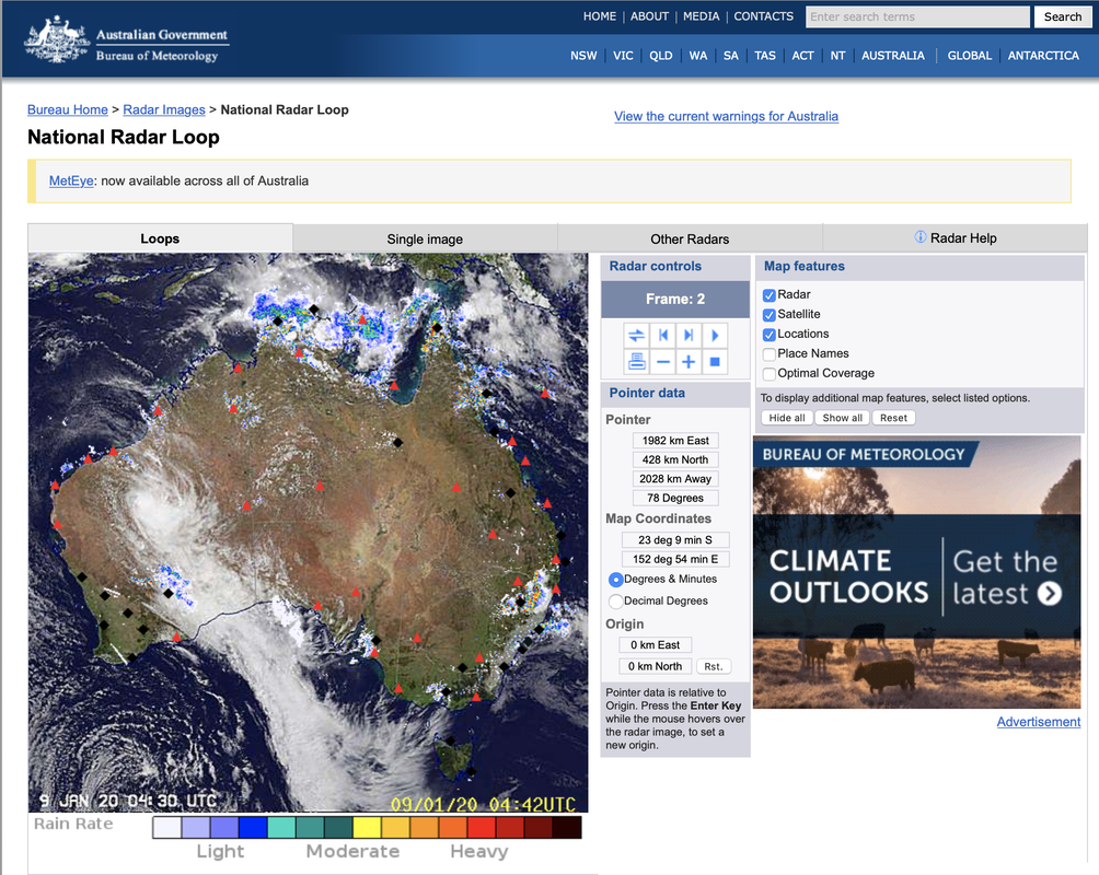 Water Our Wildlife CCWSAR Map The Central Coast Wildlife Search and Rescue created a google map to share information about feeding and watering stations to help surviving wildlife. This enables volunteers to independently visit sites for restocking. Water Our Wildlife CCWSAR Map 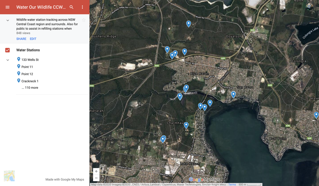  Some generic bushfire lesson plans and sequences: GTA NSW - Geography Alive - Bushfire Hazards in Australia Bushfire lesson plan - Australian Institute of Disaster Resilience Bushfire Education - Victorian Curriculum and Assessment Authority Preparing for an emergency - NSW Rural Fire Service Bushfires and grassfires - CFA, Victoria Learning about Bushfires - Victorian Curriculum and Assessment Authority
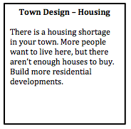
The aim of this series of lessons is to allow students to apply their understanding of Liveability to a city design task. Students work in groups of 2-3 to design a small town, as the activity progresses they will reflect on what they have learnt in the Place and Liveability topic and apply it to their town. Phase 1: Design your town The first phase of this task involves designing the layout of the town. This will involve the initial road layout, agricultural land uses, some initial commercial land uses, power supply, and water storage. Provide some student choices so that you can provide a few variations in the first round of feedback. Provide students with a base page ( it may or may not have some geographical features on it such as mountains, coastline, rivers, etc). Also provide students with some blank, coloured pieces of paper, or you can copy the templates onto coloured paper - green (agricultural land), blue (water storage), pink (commercial), red (power supply), grey (roads). 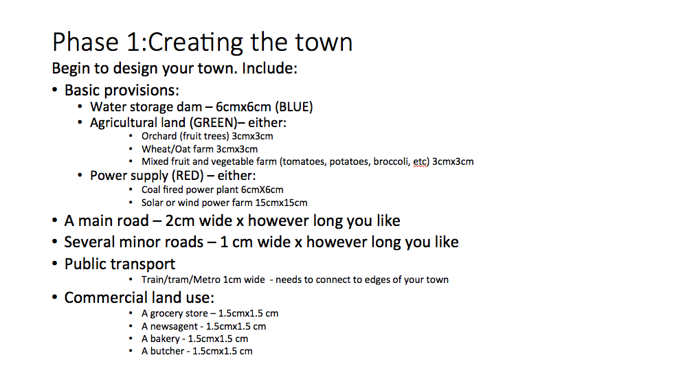
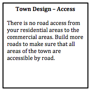
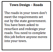
Design feedback This is an opportunity to provide some initial feedback to ensure the students get the basics right. Design the feedback so that it refers to the students as though they are members of the local council. For example, “The roads in your town don’t meet the requirements set out by the state government. You have been asked to resurface and redesign your roads. You need to complete this job before anyone moves into your town.”
Phase 2: Moving in... In the second phase of the task, students design the residential layout and density of the town. By placing a relatively small limit on the number of dwellings students have to focus on the layout of the town in the initial phases. 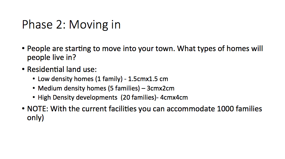
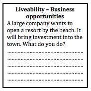
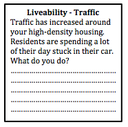
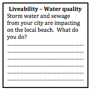
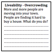
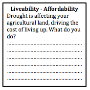
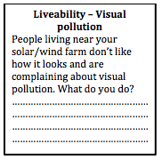
Town plan scenarios Provide students with some scenarios that will allow them to start to think about the liveability of their towns. By this stage some of the groups' conversations will have already addressed aspects of liveability, but they may not have actually considered in much depth. Students are required to write a brief description of how they addressed each scenario.
Phase 3: Enhancing liveability Students will need to respond to the scenarios above, and should have started to consider some of the additional needs of a community. As a class discuss the content related to liveability that you have already covered in class, and then provide students with time to make changes to their town plan. 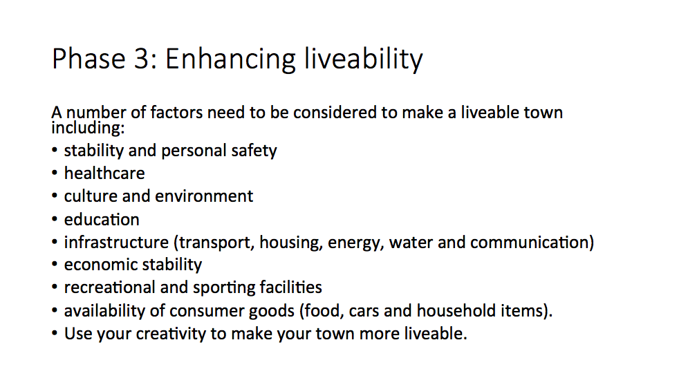 Phase 3: Liveability Students spend some time reviewing their towns and providing initiatives and strategies to make their town more liveable. They also need to address the scenarios provided by the teacher. Writing task Students need to write a description of how their town addresses different aspects of sustainability. Peer feedback Students rotate around to visit other groups' town. They provide feedback on the liveability of each town and make suggestion on how to improve liveability for each town. Next... refer to Designing a Liveable City - Part 2.
Great White Bear Tours uses custom built all terrain vehicles called Tundra Buggies. These allow unique access to the tundra environment around Churchill providing opportunities for viewing of a range of wildlife such as polar bears, arctic foxes, caribou and migratory birds. They operate tours in Spring, Summer and Autumn, and tours vary according to the seasons. In Spring they offer tours to see the Northern Lights (Aurora borealis), in Summer they operate bird watching and wildlife viewing tours and in Autumn/Fall they run Polar bear viewing tours. The company offer both one-day tours and multi-day tours. Visitors can choose to stay at the White Bear Tundra Lodge for multi-day trips. This is a custom-designed rolling hotel to enhance wildlife viewing opportunities. The lodge consists of five large units linked together - two sleeping units with shared sleeping quarters, bathroom and showers, and separate lounge, dining and kitchen facilities. The map below indicates the location of the White Bear Tundra Lodge in relation to Churchill. Examine the case study in more detail on the 12 Geography People and Economic Activity site: Nature of the economic enterprise Locational factors Ecological dimensions Internal and external linkages Effects of global changes  Is Great White Bear Tours a local case study? The NSW Stage 6 Geography syllabus requires students to examine a local case study for the People and Economic Activity topic. Depending on the economic activity studied, common case studies are local vineyards, hotels, chocolatiers. The syllabus states, "a geographical study of an economic enterprise operating at a local scale." It does not specify that it has to be in Australia, or local to you/your school. While Great White Bear Tours is not "local" to anyone studying the NSW syllabus, it can be viewed as "local" in the sense that it operates within its local area (the tours run in a relatively small geographical area, in the immediate vicinity of the business site). Let's have a look at the references to the local case study in the syllabus... There are two uses of the the word local when referring to the case study in the content section of the syllabus. In the first example it refers to the case study operating at a local level. It does not specify that it needs to be local to you or your school. Below: Screen shot from the NSW Stage 6 syllabus (Content) 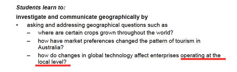 It is referred to again later in the content section where it refers to an enterprise operating at a local scale. Again there is no reference to it being local to you or your school. Below: Screen shot from the NSW Stage 6 syllabus (Content) 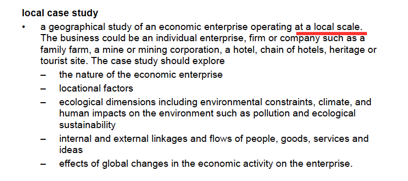 What about fieldwork? Fieldwork is an integral part of geographical inquiry and learning. It is a common practice for classes to do their fieldwork on their economic enterprise, particularly if they have chosen a case study close to the school. However, while it is common practice, it is not mandated. If we look what is mandated, the syllabus states that students need to identify methods such as "collecting and analysing field data about economic activity. Note that it doesn't state that the fieldwork has to be based on the economic enterprise (the local case study). In this way a class could conduct fieldwork on Tourism in general, but not their economic enterprise and still meet requirements. There are also many opportunities to conduct virtual fieldwork.   Explore some fieldwork options on the Year 12 Geography, People and Economic Activity site:
Fieldwork: Hudson Bay This is part of a unit of work for Changing Places - Australia's Urban Future. Lesson 1: Australia's Projected Population Growth Lesson 2: Implications for Future Growth and Sustainability Lesson 3: Sydenham to Bankstown Urban Renewal Precinct Lesson 4: WestConnex - Sydney, Sustainability and Transport Lesson 4: Sydney Sustainability and Transport (Teacher's Notes) Lesson 5: The GreenWay Lesson 5: Deindustrialisation Lesson 6: Create an infographic Lesson 7: Contributing to a Sustainable Urban Future Lesson 7: WestConnex - Protest Movements and Impacts Lesson 7: Conflict Over Dulwich Hill OR See the complete unit on the Changing Places website. Population forecasts for continued and accelerating growth or urban areas have a range of implications for sustainability. Sustainability is development that meets the needs of the present population without endangering the capacity of future generations to meet their needs. Indicators of sustainability in urban areas include air and water quality, biodiversity, integration of green building initiatives, health and well being measures, employment rates, transport infrastructure and access to employment. Implications of growth of urban areas include loss of agricultural land, habitat areas and open space, increased pressure on transport infrastructure resulting in heavy flows of commuter traffic and traffic congestion. Planning for the future growth of urban centres in Australia needs to address the provision of:
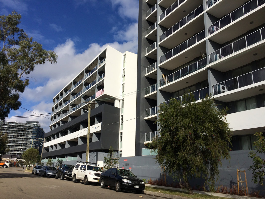
Priority Precincts and increased density An increase in density of urban areas creates more compact, “efficient” urban areas. This allows for services and infrastructure to be provided for a greater number of people and can allow residents to access public transport more easily and become less reliant on cars. The State Government’s Priority Precinct Program encourages population growth and increased density in specified areas. The Sydenham to Bankstown Urban Renewal Corridor includes the Inner West suburbs of St Peters, Sydenham, Tempe, Marrickville, Dulwich Hill and Hurlstone Park. For further reading click: http://www.urbangrowth.nsw.gov.au/assets/Living-Cities/CfS-Discussion-Paper-Making-Great-Places-Density-Done-Well.pdf Connectivity and Infrastructure Public infrastructure such as hospital, police centres, schools, trains, buses and roads is required for cities to function effectively. Upgrades of schools include Ashfield Boys, Ashbury Public, Croydon Public, and the construction of NSW School of Languages at Petersham. An ambulance super centre is being built at Haberfield. Transport infrastructure includes the construction of the Metroline and the M4 East extension, M5 extension and the M4-5 link.
Post originally written in 2017, and updated March 2018. This is part of a unit of work for Changing Places - Australia's Urban Future. Lesson 1: Australia's Projected Population Growth Lesson 2: Implications for Future Growth and Sustainability Lesson 3: Sydenham to Bankstown Urban Renewal Precinct Lesson 4: WestConnex - Sydney, Sustainability and Transport Lesson 4: Sydney Sustainability and Transport (Teacher's Notes) Lesson 5: The GreenWay Lesson 5: Deindustrialisation Lesson 6: Create an infographic Lesson 7: Contributing to a Sustainable Urban Future Lesson 7: WestConnex - Protest Movements and Impacts Lesson 7: Conflict Over Dulwich Hill OR See the complete unit on the Changing Places website. The NSW Government has released a revised Sydenham to Bankstown Urban Renewal Strategy for public comment. The strategy will be implemented over 20 years and sees plans for urban consolidation and retail opportunities along the a new metro line which will replace the existing train line and link with the Metroline being built in Sydney's north west. It includes the creation of over 35,000 new homes. View the Sydenham to Bankstown Urban Renewal Corridor website. Priority Precincts where development will be concentrated include Campsie, Canterbury, Lakemba and Belmore. Developments in these areas will include buildings up to 25 storeys high. Marrickville will have an increase in homes of 84%, while Canterbury will increase by 208%. and Belmore will increase 128%. Some suburbs such as Dulwich Hill and Hurlstone Park have had a reduction in the number of new dwellings proposed compared to the previous plan released. View Changing Places: Conflict over development in Dulwich Hill. The existing rail line between Sydenham to Bankstown will be converted to a Metro line. During construction the rail line will not be in operation. It is anticipated that once completed, it will reduce wait times and travel times to the city. However, the existing rail line allows commuters to connect with the existing CityRail network and travel to locations such as Chester Hill, Villawood, Cabramatta and Liverpool, without having to change trains. Commuters can then change trains to connect with the rest of the CityRail network. It is unclear at this stage how the Metro line will interact with the existing City Rail and light rail networks.
Residents and community groups have expressed some concerns regarding the increased level of density and population. Concerns relate to inadequate parkland and open space, destruction of heritage architecture, new designs which are unsympathetic to the heritage nature of suburbs, and lack of supporting infrastructure. There has been limited information released regarding industrial and commercial zoning, and concerns have been raised regarding the sustainability of the development. The rezoning will also take place years before the Metro line will finished. Supporters of the developments state that high density is better for the environment than urban sprawl and increases connectivity and land values in the area. The renewal strategy announcement has come at a time when residents of the Inner West are already dealing with a large number of new developments and there is a perception that there is an inequitable system of planning in place. For example Council targets for new housing approvals have been exceeded in Canterbury, but many other council areas such as Hunters Hill, Warringah, Pittwater, Willoughby and Manly have not met their targets. There have been a range of issues associated with the WestConnex development such as compulsory acquisition and demolition of houses, encroaching on parks, noise and construction issues. The recently announced future sale of Canterbury Racecourse for development has also been an issue of contention. These issues combined are likely to make Inner West residents less persuadable when it comes to future developments. Lesson Activities: Define the terms low-density, medium-density and high-density. Describe the advantages and disadvantages of each type of housing. Examine: http://www.planning.nsw.gov.au/Plans-for-your-area/Priority-Growth-Areas-and-Precincts/Sydenham-to-Bankstown-Urban-Renewal-Corridor/Map Outline the changes that will occur in each Inner West suburb as a result of the Sydenham to Bankstown Planned Precinct. Assess how the new Metroline will support population growth in the Urban Activation Precincts. Extra resources: Residents, ex-pollies baulk at high density in revised Sydneham to Bankstown Urban Renewal Strategy. Planning experts say development should be embraced and not feared along Sydenham to Bankstown corridor. Sydney's tale of two suburbs: new analysis shows the wide spread of development. Metro's on the wrong track High rise to hell Open season on high rise Heritage, character face destruction Inner West needs nine new schools
This post was originally written in January 2017, and edited in March 2018. This is part of a unit of work for Changing Places - Australia's Urban Future. Lesson 1: Australia's Projected Population Growth Lesson 2: Implications for Future Growth and Sustainability Lesson 3: Sydenham to Bankstown Urban Renewal Precinct Lesson 4: WestConnex - Sydney, Sustainability and Transport Lesson 4: Sydney Sustainability and Transport (Teacher's Notes) Lesson 5: The GreenWay Lesson 5: Deindustrialisation Lesson 6: Create an infographic Lesson 7: Contributing to a Sustainable Urban Future Lesson 7: WestConnex - Protest Movements and Impacts Lesson 7: Conflict Over Dulwich Hill OR See the complete unit on the Changing Places website. Changing Places (Year 9) The Changing Places topic requires students to explain processes and influences that form and transform places and environments (GE5-2) and to assess management strategies for places and environments for their sustainability (GE5-5). The topic requires students to examine urbanisation, the impact of migration and strategies to address change in urban places and how they enhance sustainability. As a part of examining the causes and consequences of urbanisation, students will have investigated spatial distribution patterns of urbanisation (for example the influence of transport corridors), and the social, economic and environmental consequences of urbanisation (this could include traffic congestion, costs of tolls or costs of constructing new infrastructure, average times people spend commuting to work, the impact of car exhaust on air quality). In examining urban settlement patterns students will specifically address the impact of transportation networks in Australian and another country to explain differences in urban concentrations. While there is scope to deal with a range of issues and influences related to urbanisation and urban settlement, there is certainly an opportunity to develop a unit of work that develops students’ understanding in car dependence, traffic congestion, public transport, road networks, etc. to lead them to be able to examine this issue of the WestConnex development from a range of perspectives and with detailed background knowledge. In the last part of the Changing Places topic students investigate the management and planning of Australia’s urban future, including Australia’s population projections, implications for growth and sustainability, strategies to create sustainable urban places and ways for individuals and groups to become involved. WestConnex provides a great case study to examine this. Obviously you need to address the points at the national scale, but the WestConnex project impacts on such a large are of Sydney that you might find that many of your students are already engaged with (or at least aware of) the project in some way. Urban Places/ Urban Dynamics (Year 12) If you choose to do Sydney as a large city case study for Urban Places the WestConnex project could also tie into the - growth, development, future trends and ecological sustainability dot point. 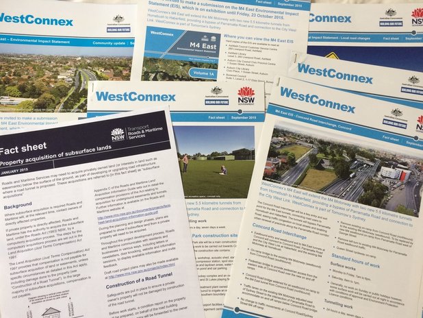 |
||||||||||||||||||||||||||||||||||||||||||