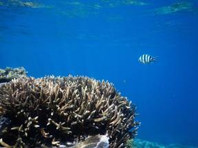
The changes in temperature and associated bleaching are resulting in a different mix of species on the reef. This will impact reefs in the long term. Loss of species Fish, whales, dolphins, sharks, rays and the many other organisms found in reefs rely on the complexity of the ecosystem for survival. Some fish rely on the colour of the corals for camoflauge and the structure of the coral for hiding. Many organisms are unable to carry out normal functions and processes as a result of the increased ocean acidification associated with climate change. Shellfish are less able to create their shells due to increased pH. Slow growing corals will take 100-200 years to recover, meaning that the reef will not exist in the form that we have known it in the past. Dispersal of spawn Ocean warming impacts on the dispersal or coral spawn (eggs). Increased ocean temperatures result in a decline in the dispersal distance of coral spawn from the origin (parent coral) to the destination site. This change in dispersal patterns can impact on species' distribution, abundance or corals in particular areas and genetic diversity across reefs. Changes to dispersal patterns can also impact on the connectivity (interconnections) between different areas of the reef by limiting the areas of reef that particular coral species are located. Poleward shift of species Ocean warming can also result in a poleward shift of species from tropical zones to more temperate zones. Warmer waters are found further from the tropics and species are able to take advantage by increasing their range. In Western Australia, a species of wrasse - cheorodon rebuscens has started to shift its range with displacement of recruits south of its usual habitat. There is evidence of high recruitment at the temperate edge and no recruitment at the tropical edge. The range shift provides limited expansion opportunities, reducing resilience of the species. Irukandji are migrating further south on the Great Barrier Reef as a result of warmer waters and are also having longer seasons in other areas. There have been anecdotal reports of increases in reports of stinging and hospitalisations on islands within the Great Barrier Reef (e.g Fitzroy Island) and snorkellers are being strongly advised to wear stinger suits outside of usual peak Irukandji seasons. Irukandji and associated stingings have also been reported on western side of the southern tip of Frazer Island where they haven't previously been found. Symbiotic relationships Following bleaching events or even natural disasters, corals can become overgrown with algae, making it difficult for coral recruits to settle and grow. The mix species on a reef can impact on how resilient that particular reefs is. For example in Moorea in French Polynesia experienced high coral mortality in the 1980s. Recovery of the reef was enabled in part as a result of grazing fish such as parrot fish removing some of the algae in the process of eating corals. In this way the biodiversity of the reef contributed to high levels of resilience on the reef in comparison to some other reefs globally. The scale of the bleaching on GBR make it unlikely that these types of natural processes will have much of an impact on recovery. Below: A parrot fish on the outer reef, 2015. 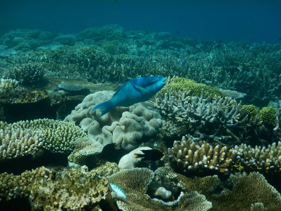
0 Comments
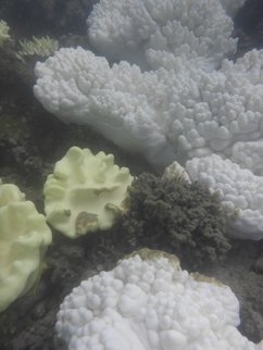 I had the pleasure of hearing Professor Terry Hughes present as part of the Sydney Ideas talks being run by the University of Sydney. Professor Hughes is Centre Director at the ARC Centre for Excellence for Coral Reef Studies at James Cook University. I use the term "pleasure" because I am a big fan of his work, and think that some of the visual representations that he has created have been incredibly powerful in explaining coral bleaching to students, but actually the information presented was really quite depressing. Image left: Photograph of bleached corals at Fitzroy Island April 2017. Hughes described some of the main drivers of degradation of coral reefs: pollution, overfishing and climate change. He explained how overfishing had resulted in the reduction of stock sizes for different species in the past century, how pollution from inland activities resulted in coral mortalities and encroachment of different ecosystems like mudflats in areas previously thriving with corals. He went on to say that the scale and extent of these changes were being dwarfed by the immediate and irreparable changes being wrought by back to back bleaching events. Below right: Bleached coral on Fitzroy Island April 2017.
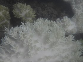
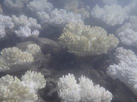
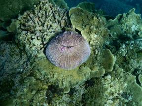
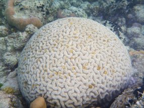
Mass bleaching events have occurred in both 2016 and 2017 as a result of increased ocean temperatures. The bleaching is as a result of corals expelling their symbiotic algae. Coral bleaching tends to occur after the summer temperature maximum, and relates to where the hottest water is. In 2016 coral bleaching severely bleached the northern third of the Great Barrier Reef, the middle section was bleached to a lesser extent, but still quite severely, while the bottom third of the reef largely escaped bleaching in 2016. This was established by the surveying of 1160 reefs through 9000km of aerial surveys, and 75 hours of flying. The 2017 bleaching event impacted the central section of the GBR, while the bottom third is again largely unbleached. Cycle Debbie, a chance weather event, lowered temperatures in the southern part of the reef, which contributed to reducing bleaching in this section. The combination of both the 2016 and 2017 bleaching events has been extremely damaging. There have been reports that the recent cyclone that affected Queensland, Cyclone Debbie may play a role in reducing the impact of coral bleaching. It was reported in the Cairns Post that the cyclone would reduce ocean temperatures, bring cooler waters to the surface and increase cloud cover, thus reducing bleaching, providing stressed corals with an opportunity to recover. The Cairns Post reported that temperatures off Lizard Island had dropped by three degrees and that this would reduce the severity of bleaching. It also provided quotes from a free diver describing the amazing colours and marine life of the outer reef. In reality, as already stated Lizard Island and the top third of the Great Barrier Reef were already severely affected by bleaching in 2016 (well before Cyclone Debbie) and were again affected in 2017. In any case, the path of the cyclone was too far south to have any real impact on areas severely affected by bleaching. Will the Great Barrier Reef recover? There is a narrow opportunity for limited recovery, but the Great Barrier Reef as we know it (complexity, extent, etc) is already dead in many areas. It will continue to exist but with reduced biodiversity. Any real opportunities to protect the reef as it remains is reliant on halting temperature increases and stabilising the climate through reducing reliance on fossil fuels. With negotiations underway between the Australian Government and Adani for for the creation of the Marmichael mines this seems highly unlikely. For more detail on coral bleaching see my article in this term's GTA NSW HSC edition of the Bulletin. http://www.gtansw.org.au Symbiotic relationships Symbiosis is a long term relationship between two organisms. There are three types of symbiotic relationship: mutualism (where both organisms benefit), commensalism (where one species benefits, but there is no benefit or harm to the other species), and parasitism (where one organism benefits tot he detriment of the other). There are many examples of symbiosis on coral reefs. Corals and zooxanthallae The relationship between the corals and the zooxanthallae is beneficial to both. Corals provide the zooxanthallae with an environment suitable for survival. It is moist and the coral's waste gives energy to the zooxanthallae. Through the process of photosynthesis the zooxanthallae produce compounds that the coral use for food. Clownfish and Sea Anemones The Sea Anemones have tentacles with stinging cells. These stinging cells kill many organisms and it is in this way the anemones get their food. Clownfish hide in amongst the tentacles of the Sea Anemone, but are not harmed by them. In this way the clownfish are protected from other predators. Occasionally the Clownfish will catch food for the Sea Anemone. Sharks and Remoras Sharks sometimes get parasites which live on the external surface of the shark. Remoras are cleaner fish, and they attach themselves to the shark and kill the parasites. When the shark feeds the Remora are able to eat the scraps from the feed. Watch the videos below, and take notes about the following symbiotic relationships: - Christmas tree worms and porites corals - Coral shrimps and corals - Goby shrimp and Hawaiian Shrimp Goby - Cleaner Wrasse and cleaning stations •Coral Reefs support a large number of plants and animals. •Coral Reefs are built by millions of tiny animals called polyps. •Some coral polyp species receive more than 60% of their food from algae. •Each coral colony begins life as a single polyp, which then reproduces itself as a single polyp, which then reproduces itself by budding or by dividing. Types of coral reefs There are eight main categories of corals: branching, corals with meandering ridges and valleys, massive or thick colonies, thin plates and crusts, solitary/isolated/free-living corals, coral with large, daytime expanded polyps, column corals and blue/fir/organ pipe/lace corals. Some examples of coral are found below:
Where are coral reefs found? Special conditions are needed for reef-building corals. Coral reefs will only grow in waters warmer than 18oC, and no deeper than 50metres. Therefore coral reefs are limited to clear, shallow tropical seas found either side of the equator. Corals may not develop properly in waters that receive freshwater runoff or sediments from rivers.  I attended the Department of Education’s STEM Showcase (see the tweet feed at #STEMShowcase). In case you’ve been living under a rock – STEM is Science, Technology, Engineering and Maths. STEM is clearly a movement that is gaining momentum, and my question is where does geography fit into this? Or History? Or Commerce? I have been trying to think of a new acronym to get us in on this movement. If you have any ideas, please let me know. What occurred to me is how many of these STEM projects have very obvious crossovers with humanities subjects, particularly geography. This post will look at a few of the presentations that I saw today and some ideas of how humanities subjects could also be included.
Baulkham Hills High School – Weather TECH Students created a STEM project involving the construction of a weather station. This involved a design process, coding of the equipment, manufacturing the equipment with a 3D printer, and collecting and analysing weather data. In the Science faculty, this was undertaken as part of a student research project. In TAS, students developed skills in using CAD and CAM software and Arduino to design, code and create the equipment. In Maths, students' skills were developed in analysing and presenting the vast amount of weather data collected. Students (and teachers) successfully created a working model with equipment collecting weather data every second. The real world applications to agriculture were emphasised. In the new NSW Geography syllabus the WeatherTECH project would fit easily within the Water In the World topic, particularly Water resources and the Water cycle. It also addresses fieldwork requirements – using weather instruments. Examine the WeatherTECH project site. Bellingen High School - Survive the Shake The topic of this STEM project was earthquake proof buildings. Students designed, produced and evaluated a multi-storey building with a small fooprint, which was specified. Students were provided with a design process to follow which provided a scaffold to follow during project. Students were required to use cheap materials such as straws, toothpicks, marshmallows, etc to create a model of their buildings. Building designs were tested on an earthquake shake table created by the teachers. In the Science faculty, the project tied into content related to earthquake size and magnitude, damage and destruction and prediction of quakes. In Maths it tied in with content related to geometry, 3D design shapes and budgets. The construction of the buildings and the design process involved the TAS faculty. In the new NSW Geography syllabus the Survive the Shake project would fit into Landforms and Landscapes, particularly Geomorphic hazards. This could easily incorporate the inquiry based learning skills in the syllabus. Examine the Survive the Shake project site. Riverside Girls High – Post-Earth Survival The girls at Riverside completed a STEM project examining the requirements to sustain life. Students explored the universe and designed a colony suitable for sustaining life on another planet. Students focused on: What do humans need to survive? The project used a design process from the TAS faculty and this was used to determine project milestones. TAS introduced the students to the tools they would need to complete the project such as Sketch Up, 3D printing, etc. Students brainstormed what it would be like if they were locked inside their house and had to stay there for 2-3 years. What would they need? What would they have to change? Students collected data on energy and water use in their own homes. From a Maths perspective students had to develop problem solving and reasoning skills, as well as data analysis. The project also incorporated the EcoMuve program from Harvard University. Assessment and presentation involved peer review and feedback. In the new NSW syllabus the Post-Earth Survival project would fit into Place and Liveability, particularly Influences and perceptions. This could also incorporate the inquiry based learning skills in the syllabus. Examine the Post-Earth Survival project site. Promoting Geography and boosting numbers A lot of time, effort and money is being spent on promoting STEM to our students. As Geography teachers, we are constantly looking for ways to promote our subject and boost senior numbers. There are plenty of ways to do this, but I think getting involved in STEM projects or at least other cross curriculum projects might be one idea that is worth a bit more consideration. BOSTES announced today that the new Elective 7-10 Geography syllabus is to be implemented in 2017. The remainder of this year is for familiarisation and planning.
Similarly to the new 7-10 Geography syllabus incorporating the Australian curriculum, it includes the Learning Across the Curriculum areas as well as the key geographical concepts of place, space, interconnections, environment, scale, sustainability and change. It includes a concepts continuum outlining which aspects of each concept should be covered in each stage. The geographical inquiry skills continuum and geographical tools continuum have also been included. The Elective course provides opportunity of geographical inquiry. The Stage statements for both Stage 4 and 5 have a whole paragraph emphasising the importance of geographical inquiry. There is an emphasis on problematic knowledge, with students required to investigate challenges, collect primary and secondary data, propose solutions and actions. Students are also required to investigate challenges from a range of different perspectives. Several of the topics allow for the exploration of an investigative study. Interestingly the Elective course is focused almost solely on outcomes and content. The Mandatory Geography course also has inquiry questions to guide each topic and a content focus, neither of which are present in the Elective syllabus. The topics in the new Elective Geography course are: - Physical Geography - Primary Production - Australia's Neighbours - Interactions and Patterns Along a Transcontinental Transect - Oceanography - Global Citizenship - Political Geography - School-developed Option A Life Skills course has been provided as part of the Elective course which aligns with topics of the mainstream course. This will make it manageable for teachers to deliver the Life Skills course within a mainstream classroom. Information is provided on reporting and to guide assessment in both the mainstream and Life Skills course. The syllabus and support documentation can be found on BOSTES: http://www.boardofstudies.nsw.edu.au/syllabus_sc/geography.html 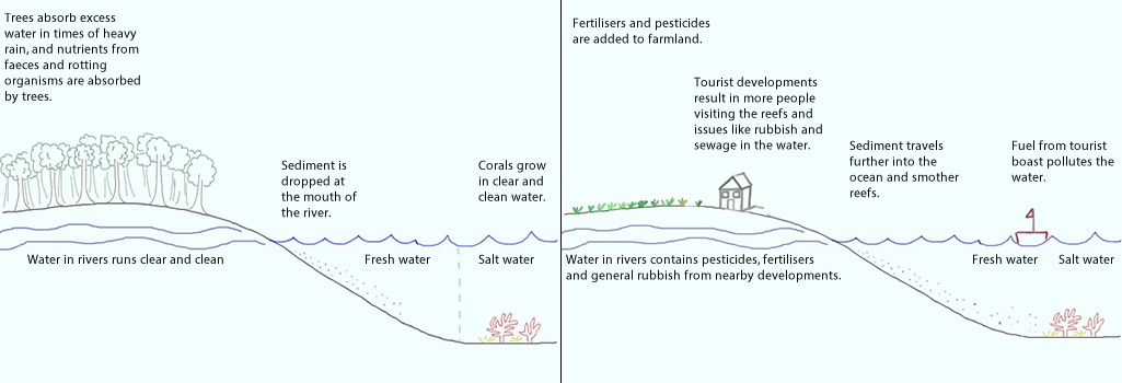 Population pressure
Increased population pressures on mainland North Queensland have resulted in increased levels of pollution and physical activities related to tourism on the reef area. Tourism The outstanding beauty of the reef attracts millions of tourists each year. The pressure placed on the reef as a result of tourism includes developments on the shoreline (and associated sewage, rubbish) increase boating activity (including oil spills, coral breakage as a result of boat propellers), and tourist activities (breaking corals while snorkelling, walking on reefs, accessing sensitive areas). Agriculture (particularly Sugar cane farming) Agriculture, especially sugar cane farming on the mainland, has resulted in increased sediment and fertiliser run-off from cane farms. In recent years, a downturn in global prices for sugar cane has resulted in farmers using greater amounts of chemicals. These chemicals run off into coastal streams and result in algal blooms and eutrophication in some areas of fringing coral near the mainland. Sugar cane farmers apply fertilisers containing Nitrogen (N) and Phosphorous (P). Many put on extra fertiliser in case of heavy rain (so it is not all washed away). The introduction of bananas as a crop in the area further increased the use of fertilisers. Of all fertilisers applied, only a third is absorbed by the crops. The rest is either evaporated, enters groundwater or runs off into nearby rivers or canals. Sugar cane crops need water to be drained away quickly. If the crops are left in water the roots will rot. As a result canals were built to drain water away quickly from the crops in case of heavy rain. These canals, or drains, reverse the cycle of how wetlands are meant to function. Rather than regulate and slow the flow of water, the water is quickly moved away from the site and into main river systems. The water rushes off the land carry fertiliser, soil, pesticides, etc. Actually pinpointing the sources of sediment is difficult, but it is believed that most is coming from land which has been tilled and let lie fallow. Sediment is also coming from bank erosion. Since European settlement erosion has accelerated due to clearing of land (less tree to stabilise soil). Due to erosion the river can erode into paddocks. There is believed to be four times more sediment reaching the coast than prior to European settlement, and in some places it is closer to 40 times. Fishing Recreational and commercial fishing have had major impacts on the reef. Commercial prawn fishing accounts of a large proportion of Queensland's Fisheries output. Approximately 6 million kgs of prawns area harvested in a good year. Recreational fishing in the General Use zones of the Great Barrier Reef Marine Park (GBRMP) accounts for 75% of the fin fish taken from the reef each year. Commercial fishing includes fishing for crayfish, finfish, reef fish, barramundi and tuna. An examination of one net which washed ashore showed it contained 14 turtles, a shark and a dugong. Gamefishing has long been an important industry in North Queensland. Pisciculture is a trend involving raising fish in fish farms (e.g. tiger prawns and barrmundi). Dredging Dredging is removing sediment from the bottom of a river bed, harbour, etc and placing it elsewhere. Links: Abbot Point: Dredging dumping permitted within Great Barrier Reef waters Abbot Point approval: Tour operators disappointed by Great Barrier Reef dredge spoil decision Approval of Galilee mega mine leaves Reef strategy in tatters. Landuse impacts on Great Barrier Reef water quality and ecosystem condition Dredging set to swamp decades of Great Barrier Reef protection WWF - Queensland resources sector needs leadership BOSTES (formerly the Board of Studies) has recently released the new NSW Geography syllabus for review. This syllabus, unique to NSW, incorporates the Australian Curriculum for Geography already being implemented in other states in Australia.
The draft new syllabus can be found at the BOSTES website along with documents outlining the features of the documents for different groups (Primary, K-10, Life Skills). The draft document does not include a Senior Geography syllabus draft at this stage. The consultation session will only run until August 29, 2014, so it is a fairly brief period. There are a number of opportunities for people to become involved: Individual responses to BOSTES There is an online survey which can be filled in, which is fairly comprehensive but contains closed questions. The survey covers topics such as views on the rationale, aims, topics, whether current resources can be used, whether it caters for a full range of students, etc. You can also make more detailed written submissions which can be emailed directly to the Senior Project Officer, Geography, Brooke Prideaux (email available at the BOSTES page linked above). BOSTES sessions: A number of sessions have been organised by BOSTES during the consultation period. These are to be held at Liverpool, Pennant Hills, Gymea and Ashfield as well as regional sessions at Moruya, Coffs Harbour, Orange and Griffith. Each of these sessions require registration very soon. Check the above-linked BOSTES page for details and links to registration. This is being organised by Eventbrite, but I'm sure that Brooke would the any questions. DEC sessions: For teachers in NSW Public Schools, the DEC Learning and Leadership Directorate are holding consultation sessions to put together a submission on behalf of the DEC. This will be done using Adobe Connect, and registration should be completed through the DEC's Professional Learning database and management system MyPL. The title is "Secondary consultation on the draft Geography K-10 Syllabus" (Course Code: NR06641). This is to take place on Monday 28 July 3.30pm – 4:30 pm. Alana Ellis, the Relieving HSIE Advisor 7-12 is the contact person, and can be contacted through her DEC email. Professional Associations and informal groups: Interestingly, the NSWGTA Annual Conference falls mid way through the consultation period. I suspect that while there doesn't appear to be a consultation session on the agenda (the agenda was released before the draft syllabus) that there may be some slight rearranging of the program to allow time for it. Online groups, such as Geography Teachers Online Australia (Facebook group) are already abuzz with discussions regarding various parts of the new syllabus. This is a great way to hear a few different perspectives and get involved in the debate. Faculties Don't forget that sometimes the best discussions can happen face to face in your own faculty. Consider what the difficulties are of the current syllabus for your students. Will the new syllabus solve these problems? Are there new issues? How will your students cope with the content? Will they find it interesting? What resources do you currently use that will fit in with new syllabus? What are the areas that are going to need a lot of work? What we already know: - Australia already has an agreed Australian Curriculum for Geography. The writing of the curriculum was completed in 2012, involved consultation between states, with professional associations and teachers, and was signed off by federal and state education ministers. There have been no discussions or public announcements about a review of this curriculum at this stage, despite reviews currently taking place of other subjects. - All states/territories but NSW began implementation of the Australian Curriculum for Geography in 2013. Like the Phase 1 subjects (English, Maths, Science, History), BOSTES decided that the structure of the Australian Curriculum was not suitable for NSW teachers, and that it would need to be rewritten to more closely resemble the current/previous syllabi. - BOSTES appointed a Project Manager to oversee the writing of the Geography syllabus for NSW as of January 2014. The former BOS had a procedure for writing new syllabi which involved hiring a team of writers, consulting with stakeholders, reviewing and refining. We can assume that a similar process was followed and that this has taken place between January and July to allow for the new document to be released. - While we are in a consultation period, we can assume that some sections of the syllabus are "locked in" while other parts are open to discussion. These have been labelled in the draft document. Please make sure you take the opportunity to have your say while we have the chance. I was lucky enough to attend the first ever TM Geography a couple of weeks ago. The teachmeet was held at Saint Ignatius' College on Monday 5 and was hosted by Jessica Lonard. Using infographics in assessment Jessica Lonard, our host, began the presentations with a presentation on how to use infographics in assessment of student learning. The room was decorated with examples of her students' work. There are a range of programs that can be used to create these infographics. One of the easiest is Picktochart. Other programs include Infogr.am, visual.ly, and easel.ly. For further information you might like to check out 10 free tools for creating infographics. Spotlight - ABS Sharon McLean presented a session on Spotlight from the Australian Bureau of Statistics which I have discussed in a previous blog: Australia's Population. This program brings population statistics about Australia to life by presenting them in a fun interactive voiced by Shaun Micallef. Flipping the geography classroom Ryan Gill presented a session about the challenges and successes of flipping his classroom including creating the videos, winning over parents and keeping students engaged. Flipping the classroom is a strategy where students are exposed to new material outside of the classroom through the use of videos, readings, etc and then class time is used to consolidate the new learning through activities such as discussions, problem solving and debates. Google Tour builder Mick Law from Contour Education showed us the latest and greatest mapping tools, concentrating mainly on the new Google Tour Builder. This seems to be a much simpler way to create a virtual tour than through Google Earth.  Nearpod Kate Corcoran showed us how she uses Nearpod in her classroom. Nearpod is a program that allows you to set up interactive quizzes and surveys and enables sharing between groups. Students log into a group and can access the resources that the teacher has made available to them on their devices. The teacher can control the students' screen while they are part of the group.  Thinglink Thinglink is a site which enables you to create interactive images. Di Laycock showed us how you can add comments, images, videos and music to create a multimedia experience from a still image.  Creating virtual field sites I went through the process of creating a virtual field site to give students access to field sites which they would not otherwise be able to experience. This is done by combining videos, photos, google tours, and links to articles all combined with the use of a blog site or website builder like weebly. Twitter: #tmgeography   |